Accelerate progress in our three core enterprises — Explore Worlds, Find Life, and Defend Earth. You can support the entire fund, or designate a core enterprise of your choice.
Phil Stooke's Curiosity route maps (updated to sol 2305)
Phil Stooke's Curiosity route maps (updated to sol 2305) Philip Stooke is author of the Atlas of Mars Exploration. Volume 2 of the publication includes these maps of Curiosity's path, which he is sharing at unmannedspaceflight.com. NASA / JPL / UA / Phil Stooke
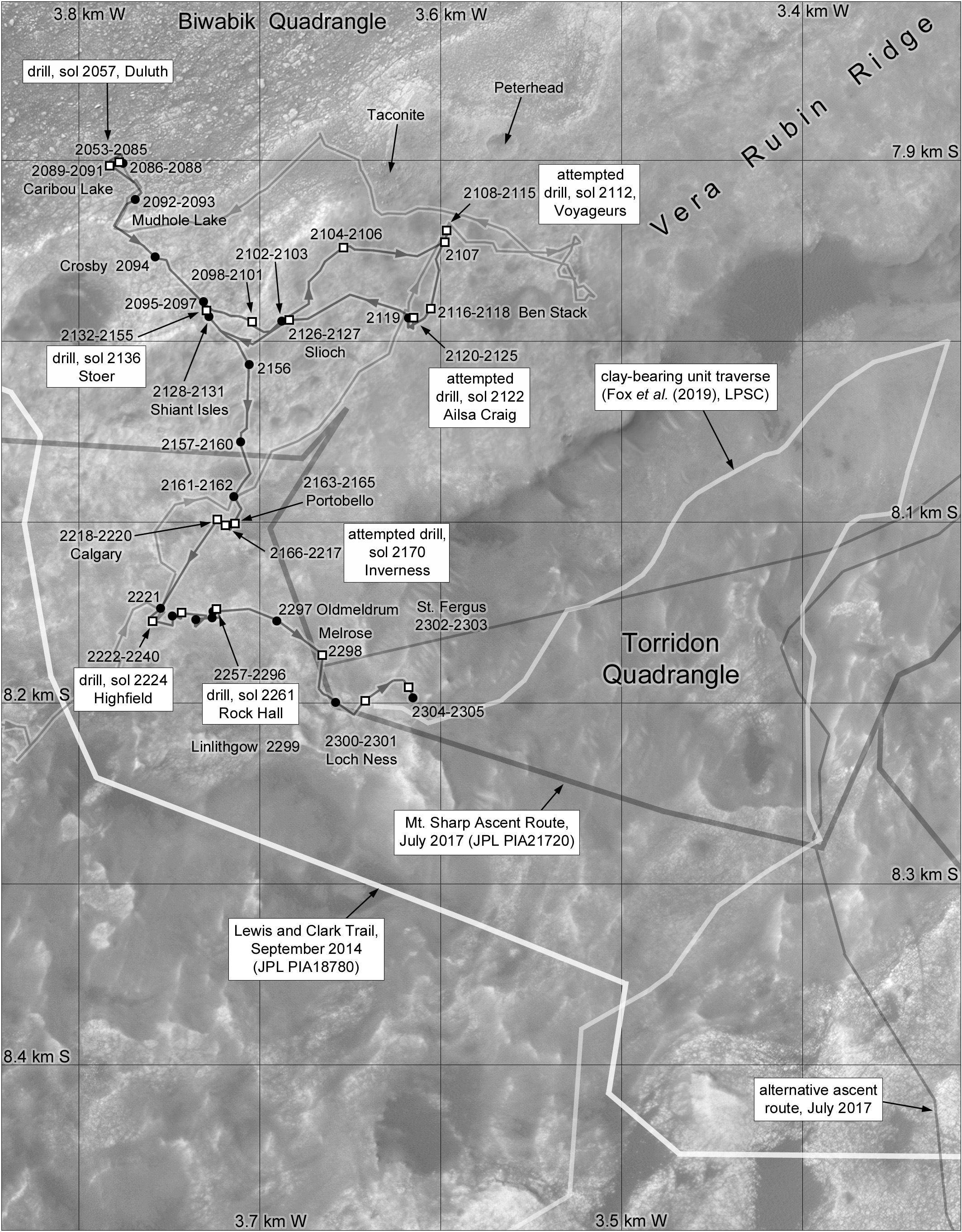
This page serves an index to various route maps for Curiosity.
Phil Stooke's Curiosity Route Map Section 1: Landing to Twin Cairns Island (sol 0-343) Visit this page for more route maps.Image: NASA / JPL / UA / Phil Stooke
Phil Stooke's Curiosity Route Map Section 2: Bell River to Allan Nunatak (sols 344-384) Visit this page for more route maps.Image: NASA / JPL / UA / Phil Stooke
Phil Stooke's Curiosity Route Map Section 3: Panorama Point and following (sols 385-423) Visit this page for more route maps.Image: NASA / JPL / UA / Phil Stooke
Phil Stooke's Curiosity Route Map Section 4: through Dingo Gap (sols 423-544) Visit this page for more route maps.Image: NASA / JPL / UA / Phil Stooke
Phil Stooke's Curiosity Route Map Section 5: Junda, Kylie, and Kimberley (sols 540-629) Visit this page for more route maps.Image: NASA / JPL / UA / Phil Stooke
Phil Stooke's Curiosity Route Map Section 6: Windjana and Robert Frost Pass (sols 603-669) Visit this page for more route maps.Image: NASA / JPL / UA / Phil Stooke
Phil Stooke's Curiosity Route Map Section 7: Zabriskie Plateau (sols 668-744) Visit this page for more route maps.Image: NASA / JPL / UA / Phil Stooke
Phil Stooke's Curiosity Route Map Section 8: Pahrump Hills (sols 743-1071) Visit this page for more route maps.Image: NASA / JPL / UA / Phil Stooke
Phil Stooke's Curiosity Route Map Section 9: Marias Pass to Bagnold Dunes (sols 974-1192) Visit this page for more route maps.Image: NASA / JPL / UA / Phil Stooke
Phil Stooke's Curiosity Route Map Section 10: Bagnold dunes and Naukluft plateau (sols 1192-1400) Visit this page for more route maps.Image: NASA / JPL / UA / Phil Stooke
Phil Stooke's Curiosity Route Map Section 11: Murray buttes (sols 1400-1467) Visit this page for more route maps.Image: NASA / JPL / UA / Phil Stooke
Phil Stooke's Curiosity Route Map Section 12: Sebina and Precipice (sols 1468-1576) Visit this page for more route maps.Image: NASA / JPL / UA / Phil Stooke
Phil Stooke's Curiosity Route Map Section 13: Ireson Hill, Ogunquit Beach and southern Bagnold dunefield (sols 1576-1697) Visit this page for more route maps.Image: NASA / JPL / UA / Phil Stooke
Phil Stooke's Curiosity Route Map Section 14: Along the Base of Vera Rubin Ridge (sols 1696-1870) Visit this page for more route maps.Image: NASA / JPL / UA / Phil Stooke
Phil Stooke's Curiosity Route Map Section 15: Vera Rubin Ridge Walkabout (sols 1830-2057) Visit this page for more route maps.Image: NASA / JPL / UA / Phil Stooke
Phil Stooke's Curiosity Route Map Section 16: Atop Vera Rubin Ridge (sols 2053-2305) Visit this page for more route maps.Image: NASA / JPL / UA / Phil Stooke