A.J.S. Rayl • Aug 03, 2015
Mars Exploration Rovers Update: Opportunity Enters Marathon Valley, Begins Walkabout
Sols 4065 - 4095
Nearly seven Earth years after the Mars Exploration Rovers mission set its sites on Endeavour Crater, Opportunity cruised into Marathon Valley, the once-but-a-dream destination where orbital data indicate there is a mother lode of bold signs of ancient past water.
"It's great to be in Marathon Valley," said Steve Squyres, MER principal investigator, of Cornell University. "It was a long haul. Based on the orbital data, the highest concentration of phyllosilicates we've ever seen with either rover is here. Just in terms of what we know about the place from orbit, it's expected to be scientifically very productive."
From high overhead, Marathon Valley looks like a notch in the Cape Tribulation segment of Endeavour Crater's eroded western rim. It stretches generally west to east for some 330 meters (1100 feet), the length of three American football fields, into the big crater.
"We didn’t know whether we’d get here," said John Callas, MER project manager, of the Jet Propulsion Laboratory (JPL), home to all NASA's Mars rovers. "When we were at Victoria Crater, we were talking about more than doubling the odometry on a vehicle that was already a factor of 12 past the design limit. Now that we’re a factor 42 beyond our design limit, we’ve entered Marathon Valley. We’re now looking around to see what we can see here. We’ve begun the exploration and the team is very excited."
Opportunity got her roving orders to leave Victoria Crater and head for Endeavour back in September 2008. It would become a three-year journey. But one year into that journey, the Compact Reconnaissance Imaging Spectrometer for Mars (CRISM) onboard the Mars Reconnaissance Orbiter, which is searching for signs of past and present water, detected signatures for phyllosilicates in the forms of smectite clay minerals along Endeavour's western rim, right where the robot field geologist was going.
A team of MER and CRISM scientists – including James J. Wray, Squyres, and Ray Arvidson, MER deputy principal investigtor, of Washington University St. Louis – reported on CRISM's discovery of clay minerals at Endeavour Crater in 2009.* It was a big, big deal. Clay minerals form in the presence of water and these minerals on Mars, therefore, would be harboring evidence of ancient wet environmental conditions.
Finding clay minerals was never on Opportunity's list of science objectives, though it is on the list for the Mars Science Laboratory's Curiosity rover. Certainly the presence of phyllosilicates fits the story of the 22-kilometer (13.7-mile) diameter Endeavour, a Noachian Period crater that formed around 4 billion years ago, a time when scientists now generally believe Mars was a lot more like Earth. And Opportunity is the only surface mission exploring these ancient grounds.
As it turned out, Opportunity grabbed the "brass ring" and the MER mission made history in 2013 when it became the first surface mission to rove over the most ancient Noachian Period bedrock found on the surface of Mars to date, and the first to ground-truth the presence of phyllosilicates on Mars. And those discoveries came from "weak" signatures that CRISM detected in the Cape York segment of Endeavour's eroded western rim, on Matijevic Hill, named in honor of Mars rover pioneer and member of the original MER design team, JPL's Jake Matijevic.

A marathon view
Opportunity drove into Marathon Valley in July 2015, some six Earth years after the Compact Reconnaissance Imaging Spectrometer for Mars onboard the Mars Reconnaissance Orbiter detected exposures of clay minerals there. Transverse Aeolian Ridges (TARs), which form the ripple field, on the floor of Endeavour Crater, are beautifully visible in this false color image processed by the Panoramic Camera (Pancam) team. "I think you're going to get used to seeing some pretty spectacular images from this place," said MER Principal Investigator, Steve Squyres, of Cornell University.NASA / JPL-Caltech / Cornell / ASU
At Marathon Valley, CRISM has picked up the strongest signatures in the whole of Endeavour's western rim, indicating the presence of different kinds of clay minerals there, just waiting for Opportunity.
"Exciting" was the operative word for the MER mission in July.
"We’re terribly excited!" said Matt Golombek. MER project scientist and senior research scientist, JPL. "We finally got to Marathon Valley!"
"To be starting our imaging and our science campaign is incredibly exciting," agreed Bill Nelson, chief of MER engineering at JPL.
"Right now, we're seeing big, flat exposures of light-toned bedrock as we head in toward Endeavour," said Squyres. "The interesting question is: will this have any relationship to what we saw at Matijevic Hill? So far the rocks don't look like the Matijevic Formation rocks. They look like something different, just visually."
They're not seeing any newberries, for example, or similar layering in the rocks that Opportunity found on Matijevic Hill, "at least not in any obvious way," said Squyres. "We may be dealing with something new and different here. It's just a little too early to tell."
For the most part, the MER team knows where to send Opportunity sleuthing for the clay minerals. That's because Arvidson, who is also a co-investigator on CRISM, acquired more detailed orbital data from the spectrometer that he used to create a more definitive clay mineral map. He did the same thing in 2012 when Opportunity was exploring Cape York, which is how the team was able to zero in on the "sweet spot" of Matijevic Hill.
Specifically, Arvidson requested that CRISM acquire data of Marathon Valley in a mode known as along-track oversample (ATO). This technique sharpens spatial details, reducing the pixilated areas in the original CRISM data from 18 meters to about 5 meters, enabling the scientists to better home in on the location of the clay minerals.
Using this additional data, Arvidson created a pixel-by-pixel map showing where the orbital spectrometer was picking up the signatures of different kinds of clay minerals. The MER scientists have the clay mineral map overlaid on an orbital image of Marathon Valley taken by the HiRISE (High Resolution Imaging Science Experiment) camera onboard MRO, said Golombek. Most recently, they used it to determine the waypoint stops on Opportunity's first science assignment inside Marathon Valley, a walkabout to get "the lay of the land."
Since CRISM already "discovered" the clay minerals, Opportunity's objective in Marathon Valley, as on Matijevic Hill, is to examine these clay remnants in their natural context – where they are found, how they are situated with respect to other minerals, and the area's geological layers – all of which will help the scientists gather more information about the ancient, watery environment once present at Endeavour Crater.
Opportunity continues to operate in RAM-only mode while a team of current and former MER engineers investigates the rover's errant flash storage system or long-term memory. The flash is non-volatile flash memory that can retain data even when power is turned off overnight, while RAM – or random-access memory – is volatile memory and only retains data while power is on. That means when the robot is storing all her science and engineering data to RAM, she must uplink all data to the Mars Odyssey orbiter before she goes to sleep or naps. If she doesn't, it won't be there when she wakes up.
The rover's flash or long-term memory has been in "offline" several times in recent MER history. It was successfully reformatted twice in 2014, but that didn't eliminate the issues. Another reformat of the memory in March of this year masked off a sector or "bank" believed to be corrupted. That reformat also temporarily slowed the frequency of flash-induced computer resets – or sudden reboots of Opportunity's computer – but then the resets increased again in April and May.
Just before Earth-Mars solar conjunction in June, the MER team erred on the side of caution and took the rover's flash offline during the three-week communications blackout period that comes with the biannual celestial alignment of the two planets. The robot field geologist came through solar conjunction "just fine," said Nelson.
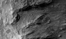
Marathon Valley overhead
This image, taken by the HiRISE camera onboard MRO, shows Marathon Valley, which stretches about 330 meters (1100 feet) into the 22-kilometer (13.7-mile) diameter Endeavour Crater (unseen to the right). Spirit of St. Louis Crater is visible in the lower left of image; the round dark spot inside it, right side, is Lindbergh Mound.NASA / JPL-Caltech / UA
Opportunity did use her flash for a few sols in July, but it was "unstable," as Callas put it, and the rover was promptly commanded back into RAM mode.
Not having flash isn't something that can stop this rover or the mission. The robot proved that she could work productively in what the MER engineers call "persistent RAM mode" for several months prior to the last reformat, and has had no significant issue in this mode during the last several weeks. "The only real drawback is that the rover must transmit data it collects that same sol," said Callas.
While the MER engineers mull over the next possible options for repairing the Opportunity's long-term memory drive, the scientists are planning for the best but are prepared, as always, for the worst. "If we have to run the rest of the mission in RAM mode, we'll run the rest of the mission in RAM mode," said Squyres, matter-of-factly. "We'll see."
As July wound down, Opportunity revved up and started right in on the planned walkabout of Marathon Valley. The robot field geologist began by checking out a flat, light-toned rock named Private Reubin Field, after a member of the Corps of Discovery, better known as the Lewis & Clark expedition.
"We're going to do a clockwise loop around the valley, heading eastward around the north wall, and then crossing down to the south side and driving westward along the south wall," said Squyres.
Along the way, Opportunity and her team will be looking for the best winter Sun-facing slopes in Marathon Valley. In fact, the team has already spotted some choice slopes on the southern end of the valley, where the veteran rover will spend her seventh Martian winter. "The intention is to be on the south wall once winter starts coming on," confirmed Squyres.
As Martian months go, July was pleasant enough. With summer turning to fall at Endeavour, the skies were typically hazy. But the solar-powered rover was producing on averaged around 440-watt-hours, a little less than half her capability with spanking clean solar arrays.
With the exception of her troubled flash, Opportunity "is still doing great and still doing great science," summed up Callas. "The rover is indeed doing well," added Nelson. "It may even be that we’re in an area where we’re going to get some of the dust blown off. We haven’t seen that yet, but we’re hoping."
The MER team, like Opportunity, is keepin' on keepin' on, well oiled machines, literally and figuratively. "We come into work every day and operate the rover," said Golombek.
The plan ahead is for the rover to be active through the coming winter, examining outcrops that contain clay minerals and sure signs of past near neutral water… water like we humans might drink. What else Opportunity will find, no one really knows. The exploration in this highly anticipated clayground has only just begun.
"All we have down is data on one rock," said Squyres. "It's just too early to say what we have scientifically." But the MER mission is going to "downshift" now and start digging in at this new wonderland.
"It's pretty dramatic here," Squyres reflected. "I think it's one of the more beautiful places we've been on the whole mission."
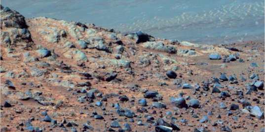
NASA / JPL-Caltech / Cornell / ASU
Entering Marathon Valley
Opportunity took this image of the northern wall at the entrance of Marathon Valley on July 15, 2015 as she drove in. The ripple field that lines the floor of Endeavour Crater can be seen in the upper right half of the image. "It's great to be here," said MER Principal Investigator Steve Squyres, of Cornell University.As June turned to July, Opportunity was less than 55 meters (about 180 feet) from the entry point of Marathon Valley. When the rover woke up on her Sol 4065 (July 1, 2015), she was on northern edge of Spirit of St. Louis Crater, hunkered down in patch of reddish materials conducting an in-depth investigation of rock target Ryan NYP.
Named for the classification of the Ryan Airlines monoplane that Charles Lindbergh flew solo in the first transatlantic flight, Ryan NYP was the plane Lindbergh christened Spirit of St. Louis. Like all the targets in the small crater, the rock called Ryan NYP was named in honor of Lindbergh's history-making flight.
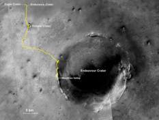
Marathon destination
The gold line on this image shows Opportunity's route from the Eagle Crater landing site to her approximate current location. Since August 2011, the MER mission has been investigating the western rim of Endeavour Crater, which spans about 22 kilometers (about 13.7 miles) in diameter. The base image for the map is a mosaic of images taken by the Context Camera onboard the Mars Reconnaissance Orbiter (MRO). Larry Crumpler, of the New Mexico Museum of Natural History and Science, provided the route add-on.NASA /JPL-Caltech / MSSS / NMMNHS
Opportunity was in the midst of finishing up a transect or in other words, an investigation of several targets in the Red Zone. This zone is composed of patches of reddish materials here and there along the edges of the Spirit of St. Louis Crater and the MER scientists were looking to find out what this red stuff is.
The robot field geologist spent the first few sols of July taking pictures of Ryan NYP with her Microscopic Imager (MI) for a mosaic and gleaning the chemical composition of the red stuff with her Alpha Particle X-ray Spectrometer (APXS).
As the second week of July took hold, Opportunity turned her focus on Sol 4072 (July 8, 2015) to nearby rocks and targets, documenting them with full color, 13-filter Panoramic Camera (Pancam) images. That same sol, the robot also set up her Navigation Camera (Navcam) to capture images of any clouds or dust devils that might be passing through. Apparently none did.
On Sol 4073 (July 9, 2015), the rover bumped 25 centimeters (about 10 inches) to position her Instrument Deployment Device (IDD) or robotic arm over a new target in the Ryan NYP patch within this area of Red Zone. Then, after the bump, she took, some "post-drive" Pancam pictures.
It was a productive sol and since Opportunity was working in persistent RAM mode, everything "shipped" to the Mars Odyssey orbiter that night, for downlinking later to Earth. Later that night though, the robot pointed her APXS skyward and took an argon measurement for the mission-long study on Mars' atmosphere. Since the APXS has a flash type memory, the team would record the data later directly from the instrument.
Opportunity spent her Sol 4074 (July 10, 2015) taking more 13-filter Pancam "postcards" and waiting, Navcam in hand, for clouds or dust devils. Again, none apparently blew through. Then, the following sol, 4075 (July 11, 2015), the robot field geologist got to work on her final science investigation in the Red Zone. Following the same protocol of the last several years, she first took close-up pictures with her MI for the scientists to put together into a mosaic, and then placed her APXS on the target to determine its chemical make-up.
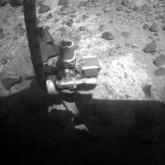
Hunkered down at Ryan NYP
As July dawned at Endeavour Crater, Opportunity was hunkered down over Ryan NYP, a target in the Red Zone along the northern edge of Spirit of St. Louis Crater. The Red Zone rocks have "concentrations of water soluble things, like chlorine and sulfur," said MER Project Scientist Matt Golombek. The red coloration may be caused by hematite, but since the rover no longer has use of her mineral detectors, that's an inference. The analysis of the rover's data continues.NASA / JPL-Caltech
"What was interesting is that the rocks on either side look pretty much the same, with the Red Zone rocks having concentrations of other elements, generally the water soluble things, like chlorine and sulfur," said Golombek. "We're still sorting all of that out."
The reddish hues in the Red Zone could be caused by the presence of hematite. "But that is not a definitive mineralogical identification," cautioned Squyres. "If we still had Mössbauer and Mini-TES, we could answer that. So hematite is an inference."
On Sol 4076 (July 12, 2015), Opportunity hung out with her Navcam running, looking again for clouds and dust devils. "Nothing obvious yet," said Golombek. "But a lot of those didn’t come down because of our being in persistent RAM mode."
It's not exactly a peak time to look for either. "The best time to watch for clouds is in the depths of winter and for dust devils is in summer and we're in neither right now," noted Squyres.
Opportunity pressed on. The rover headed around Spirit of St. Louis Crater to the east with a 27.5-meter (about a 90-foot) drive on Sol 4077 (July 13, 2015). After the drive, the robot took a panorama with her Navcam and visually documented the scene from her new vantage point.
Although the robot had completed her work at Spirit of St. Louis Crater and roved on, the MER scientists on Earth lingered on the small bizarre crater. "That turned out to be quite an investigation," chuckled Golombek. "We had a very hysterical discussion about whether it was really a crater or not. When planetary scientists use the term 'crater,' they're usually referring to an impact crater, even though technically the definition is a depression. This small crater is a depression and it has a little bit of a rim. But we don’t know for sure if this crater is an impact crater. It has this big giant mound [Lindbergh Mound] sticking up in the middle. So we really don’t know how this thing formed."
"There was kind of an amusing exchange that went back and forth on email where people were arguing semantics and terminology as opposed to geology," said Squyres. "You can get very hung up on terminology if you let yourself."
At the moment, there are two competing hypotheses for how Spirit of St. Louis came to be: one holds that it is a secondary impact crater formed by ejecta from whatever created one of the other large craters in Meridiani Planum; the other theory maintains that it is some kind of volcanic feature. "We don’t know," Golombek said.
"Most of us believe it's probably a secondary impact crater," said Squyres. That secondary impact could have come, he said, from whatever formed Bopolu Crater, a 19 kilometer (12-mile) diameter crater about 65 kilometers (about 40 miles) to the southwest of the rover's location, as Arvidson suggested previously.
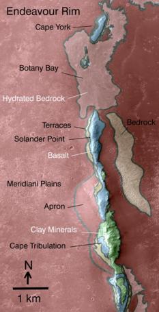
Geologic riches in Endeavour
This map reveals the locations where the Compact Reconnaissance Imaging Spectrometer for Mars (CRISM) onboard MRO first detected clay minerals at Endeavour Crater in 2009. As indicated by the scale bar of one kilometer (0.6 mile), this map covers only a small portion of the 22-kilometer (13.7-mile) diameter crater's western rim. A discontinuous ridge runs north-south, exposing basalt (in blue) and clay minerals (green) believed to be from a time several billion years ago when Mars was more like Earth.NASA/JPL-Caltech/JHUAPL
"Bopolu is a possibility and it's in the right direction," said Squyres. "Spirit of St. Louis Crater is elongated and if Lindbergh Mound is the not-completely-eroded-away remnants of the thing that formed it, then it would be on the downrange side. If you look at the elongation and infer the up range direction, and then follow that as a method, it takes you right to Bopolu. It all fits."
Opportunity finished out the second week of July on Sol 4078 (July 14, 2015) with her departure from Spirit of St. Louis Crater. The rover took off, heading northeast, in the direction of Swann Hill, putting 36.7 meters (120 feet) in her rear view mirror. Then after the drive, as usual, she took a Navcam panorama.
The next sol would be the day the MER team has anticipated for years. Opportunity was ready. The MER team members were ready.
After waking up on Sol 4079 (July 15, 2015), the robot field geologist took some pre-drive targeted images with both her Navcam and Pancam and then drove 18.85 meters (almost 62 feet) into Marathon Valley. When Opportunity stopped, her odometer was at 42,452.08 meters.
Nearly six years after CRISM first lit up with a mother lode of clay minerals in this section of the Endeavour's eroded western rim, the rover that loves to rove achieved what once seemed unlikely, if not downright improbable. Opportunity looked around, like you or I might look around, shooting a 360-degree Navcam panorama as she drank in her new surroundings.
The next sol, 4080 (July 16, 2015), the rover put in a very light workday, to no fault of the mission. A problem with the Deep Space Network (DSN) failed to deliver the rover's commands, so Opportunity carried out a preprogrammed sequence of routine tasks.
On Sol 4081 (July 17, 2015), she drove on, deeper into the valley toward Endeavour, putting another 29.47 meters (96.86 feet) behind her. "The thing that is most striking to me is how Marathon Valley slopes down as the rover goes forward," said Callas. "It’s not like having this nice, flat, wide valley with precipitous walls on either side that give you these dramatic views. It keeps sloping down into Endeavor Crater. I didn’t realize that the slope keeps pitching steeper as you go further down in."
"As we drove, we kept not seeing most of Marathon Valley, because of the way the terrain is convexed up [sic]," said Golombek. "It’s not like we see it all in front of us and we see where to go. A lot of it is still kind of hidden from view."
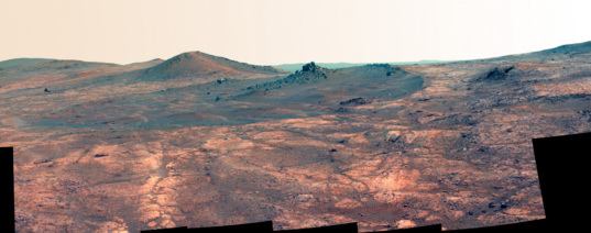
NASA / JPL-Caltech / Cornell / ASU
Spirit of St. Louis Crater
Opportunity took this image of the odd, elongated Spirit of St. Louis Crater with her panoramic camera (Pancam) in March 2015. This image was processed by Planetary Society President Jim Bell, Pancam lead scientist, of Arizona State University (ASU), in false color to make differences in surface materials more easily visible. The rockpile toward the crater's far end, upper center of image, is Lindbergh Mound. Although the robot spent months checking out this small crater, inside and out, it remains an enigma. "We still don’t know how this thing formed," said MER Project Scientist Matt Golombek.During the evening of Sol 4081 (July 17, 2015), Opportunity followed her commands and turned on flash and began using her long-term memory drive. "The first day that worked really good and we got some data out of flash that would have otherwise been inaccessible," said Nelson.
The rover spent the next two sols, 4082-4083 (July 18-19, 2015) taking a lot of images with her Pancam, primarily imaging of north wall of Marathon Valley. Then, on Sol 4084 (July 20, 2015), Opportunity "bumped" 2.94 meters (9.64 feet), to an outcrop of flat, light-tone outcrop the team named after Private Reubin Field, another member of the Corps of Discovery, better known as the Lewis & Clark Expedition for which the MER team has been naming targets since February of this year.
"We were in flash for three days [sols]," reported Callas. "We wanted to see the state of flash after solar conjunction, but it was unstable."
Opportunity suffered a fatal error during her uplink to Odyssey on Sol 4085 (July 21, 2015), and went into a kind of auto mode. "We tried to mount flash and that didn’t work," said Nelson. "And then we had a computer, a warm reboot, so the computer crashed and the rover went into cripple mode. The [work] sequence was killed, and all of our planning for that sol was lost."
So, the robot was commanded back into persistent RAM mode on Sol 4086 (July 22, 2015) and Opportunity returned to uplinking everything she had stored in RAM to Odyssey at each sol's end.
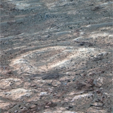
Salamis
Opportunity used her Pancam in early July to shoot this intriguing color image of Salamis, a light-toned bedrock feature complete with a "dimple." You can see the rover's wheeltrack cross the geologic feature. It was processed in false color by the Pancam team.NASA / JPL-Caltech / Cornell / ASU
Meanwhile on Earth, the MER flash tiger team and the contingent of original MER engineers continued their investigation into the rover's errant non-volatile flash. The engineers have lots of ideas on what could be happening and how potentially to remedy it, but "there are no credible hypotheses yet," said Callas.
"It’s quite possible that there are several things going on," said Callas. "The reality is that this flight software is old and it’s gone through more than 4000 thermocycles on Mars. And so we’re looking to see how we can use the flash in a stable or predictable way, such that we can get some benefits out of it."
Until then, Opportunity can and will continue her science mission in RAM mode. But now that the rover is inside Marathon Valley, the team wants to collect all the hundreds of images needed to produce those huge, glorious Mars panoramas that have become a hallmark of the MER mission. "The big Pancam pans really open up Mars to the way we'd experience Mars if we were there ourselves," said Squyres. "And it’s a lot easier when you have flash so you can store some of those images to send later," said Callas.
In addition, while there is always concern going into winter, "without having flash, it’s going to be a little more challenging this winter than last winter," Callas noted, "because the rover can’t nap as conveniently as in past winters."
The MER engineering team is already on it. "You have to be awake for the period when you collect the data through the time when you downlink it, and as we move into winter, staying up for long periods of time will become increasingly difficult," Nelson elaborated. "We’re trying to solve that two ways. "We’re looking to move the uplink time, the so-called handover time to later in the sol, so instead of uplinking at 11 o’clock, we’d uplink maybe at 12:30. And then we wouldn’t have to stay up for that extra hour and a half," he explained.
The other thing that the MER ops team is looking to do is get more MRO passes. "Odyssey doesn’t come overhead until around 5 p.m., local Mars time, and it’s moving back out around 6 p.m.," said Nelson. "The MRO orbit is such that it comes overhead early in the afternoon, around 2 o’clock, so we can have a fairly short period of time when we’re up and then we can just go back to sleep. If we can average enough of those through the wintertime, we shouldn’t really have any problems."
As the last week in July took hold, Opportunity pressed on working like robots do. She took pictures on Sol 4087 (July 23, 2015) and again focused her Pancam on the north wall of Marathon Valley.
"There’s this escarpment, a steep slope with rocks and other stuff, and we'd been trying to image it," said Golombek. "The difficulty is that it’s a south-facing slope, and when we get around to imaging, it’s usually in the afternoon and it’s all in shadow. We've been having a devil of a time trying to get good images of the rim and we want to do that, to document what we're seeing."
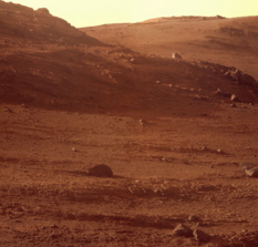
Inside Marathon Valley
Opportunity took the pictures of this view looking to the north side of Marathon Valley and beyond with her Panoramic Camera (Pancam) during the late Martian afternoon on July 23, 2015, the rover's Sol 4087. James Canvin, an unmannedspaceflight.com moderator, processed the raw images into this near-true Martian color picture.NASA / JPL-Caltech / Cornell / ASU / J. Canvin
Opportunity also took images of what Mars scientists call Transverse Aeolian Ridges (TARs), which form the ripple field on Endeavour's floor below Marathon Valley. Aeolian processes are probably the dominant ongoing surface process on Mars. So far, scientists have described the aeolian bedforms or TARs common in this rovers' parts of Meridiani Planum as ripples and not small dunes. [Purgatory Dune, where Opportunity got stuck back in April 2005 was officially declared a ripple after being named, but the name stuck.]
Opportunity finally began her up-close, IDD campaign on Private Reubin Field on Sol 4088 (July 24, 2015) and also devoted the next sol to the target. Following the science protocol, the robot took stereo images with her MI and then placed her APXS down on the same chosen spot to determine its chemical composition on each sol.
Flash would have come in handy for this assignment. The combined MIs from Sols 4088 and 4089 would be put together into one mosaic. "The work was split across sols because imaging generated created more data than could be downlinked in one sol," explained Nelson.
The robot field geologist then spent Sol 4090 (July 26, 2015) taking more Pancam images of the ripple field on the floor of Endeavour, monitoring dust on her Pancam Mast Assembly, and running her Navcam to once again try to capture a dust devil.
The next sol, 4091 (July 27, 2015), Opportunity examined another spot on Private Reubin Field, adjacent to original, dubbed Private Reubin Field 2. First, the robot pulled out her Rock Abrasion Tool (RAT) and brushed the spot, then took the requisite images for an MI mosaic. "We want to get at what the rock looks like inside the brushed area," said Golombek. "The idea is to establish some baseline of what this rock is, because we’re on this expanse of it."
Opportunity took more images of nearby sites and targets in her new surroundings the following sol, 4092 (July 28, 2015), and after the uplink to Odyssey, conducted an APXS integration on Private Reubin Field 2. Since the APXS has a flash type of memory onboard, the team would pick up the rover's chemical findings directly from the instrument the next morning.
"We see large dark rocks that look like they are falling down the slope," said Golombek. "They are sitting on a reasonably flat valley floor. Underneath these rocks that look like they’ve come down the slope are the light-toned rocks [like Private Reubin Field] that to me don’t look all that different from the light-tone Shoemaker breccias that we’ve been seeing all along the rims," opined Golombek.
Squyres, true to his character, was not forthcoming on guessing. "It's just too early to tell," he reiterated.
The hope, at least in previous months, was that Opportunity would rove onto more Matijevic Formation bedrock, the ancient, oldest Noachian strata that any landed mission has found so far. Since the robot field geologist's discovery in 2012-'13, Matjevic Formation bedrock has been almost conspicuously elusive.
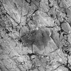
Pvt. Reubin Field
Opportunity took this close-up image of the light-toned rock outcrop the team named in honor of Private Reubin Field, one of the hunters on the Corps of Discovery Expedition, more popularly known as the Lewis & Clark expedition. James Canvin processed this version from the raw pictures the robot took with her Microscopic Imager (MI) on July 29, 2015, and then sent home to Earth. For more of Canvin's work, please visit his Martian Vistas site.NASA / JPL-Caltech / J. Canvin
Private Reubin Field, however, is missing the newberries and layering that defined Matijevic Formation rocks, as Squyres pointed out. It could be because this flat, light-toned bedrock is more breccia or it could be something completely new and different. Time will tell.
In any case, the walkabout of Marathon Valley effectively began with Private Reubin Field. "We’re in it," confirmed Golombek. "We’re going to do the full-up IDD campaign, and hopefully do some more imaging around as well to establish the light-toned and dark-toned rocks that we see."
From Private Reubin Field, Opportunity will loop around Marathon Valley on her walkabout. "We have about five stops identified along the north rim, before we circle around to the southern part of Marathon Valley where we see north-facing slopes that will improve our power by the time winter comes," said Golombek.
The MER mission however has always been discovery driven. Considering the walkabout stops are based on areas where the scientists see clay minerals on Arvidson's CRISM map, nothing at the moment is written in stone. "As we go along the ground, we will make decisions based on what we see as we go," said Golombek.
Right now, it is early autumn in the southern hemisphere of Mars where Endeavour Crater and Opportunity are located. The shortest day and longest night of the hemisphere's winter, winter solstice, won't come until January. But as the Sun's daily track across the northern sky gets shorter, there will be less sunlight "fuel" in a given sol for the solar-powered robot to take in and utilize for power.
Whatever Opportunity finds, the rover is slated to spend her seventh Martian winter at the southern end of Marathon Valley. "Martian winter comes on slowly and so there's no definite point when winter arrives," said Squyres. "But we will see a gradual reduction in power as the months progress from here. In a matter of a few months from now, we're going to want to be on the south side of the valley and on slopes facing north."
By positioning herself on north-facing slopes on the southern side of the valley, Opportunity can angle her solar panels directly toward the Sun to boost the amount of electrical energy she can produce each sol during the harsh season. "We’re ahead in terms of factoring where we were last season on Mars," said Callas. "And we have some north-facing slopes at the southern half of Marathon Valley that give us a 15% northerly tilt, which is sort of the ideal number."
The Martian winter notwithstanding, the outlook is still bright for Opportunity. So far her power is looking good, hovering around 420 watt-hours or higher, and the skies are dusty but not too dusty. Best of all, the rover is inside her next big attraction and has plenty of time to take her time.
"We’re going to take our time, because this is where we came to," Golombek said. "And what we came for."
NASA / JPL-Caltech / UA
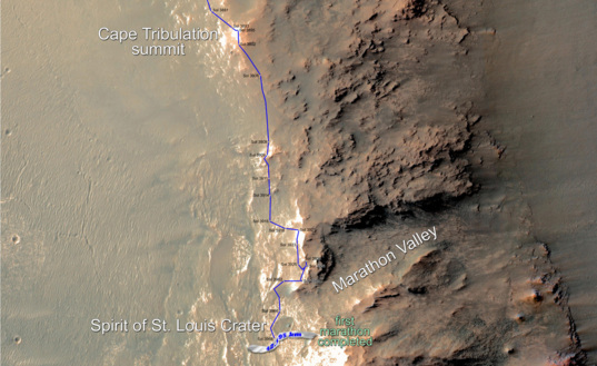
Marathon Valley: Opportunity has arrived!
This map shows the southward path Opportunity took along the west rim of Endeavour Crater from late December 2014 until she passed marathon distance on March 24, 2015. Since then, the rover roved around and into Spirit of St. Louis Crater. In July 2015, six years after the Compact Reconnaissance Imaging Spectrometer for Mars (CRISM) onboard the Mars Reconnaissance Orbiter detected clay minerals there, the veteran rover drove into Marathon Valley – and the MER mission began all over again.*Citation: J.J. Wray, et al., "Phyllosilicates and sulfates at Endeavour Crater, Meridiani Planum, Mars," Geophysical Research Letters, Nov. 4, 2009.
Support our core enterprises
Your support powers our mission to explore worlds, find life, and defend Earth. You make all the difference when you make a gift. Give today!
Donate

 Explore Worlds
 Find Life
 Defend Earth


