Emily Lakdawalla • Jun 03, 2020
Every Mars landing attempt as of June 2020
EDITOR'S NOTE: These infographics are current as of June 2020. An updated Mars landing map is available here.
It’s almost Mars launch season again! Once every 26 months, as Earth runs on its inside track around the Sun, physics favors launches from our planet toward Mars. There are 3 Mars-bound missions that plan to launch in July, and 2 of them hope to land. (The one that won’t land is just named Hope.) NASA will be launching the Perseverance rover, and China its Tianwen-1 orbiter and rover. There was to have been a 3rd rover launching this summer, but the European Space Agency had to delay Rosalind Franklin and Kazachok’s mission until the next opportunity comes around in 2022.
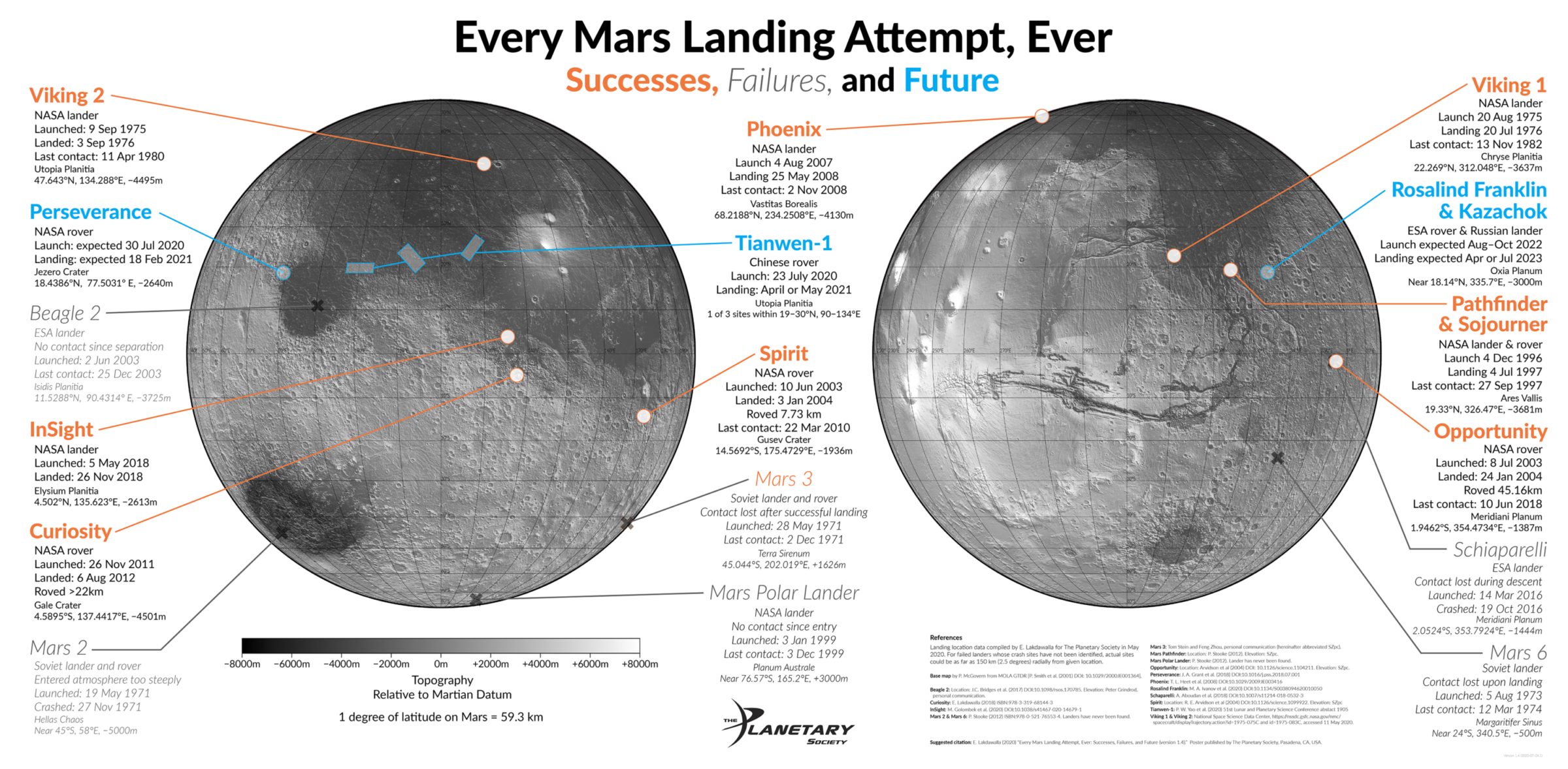
Many years ago, as Spirit and Opportunity were readying for launch, I produced a map of all the locations of landed Mars missions, both failed and successful. Since then I’ve updated it with Phoenix, Curiosity, Schiaparelli, and InSight. Now that we have several new missions planned, I figured it was time for a complete do-over. Here it is!

To make this map, I dug into publications about landing site locations to get precise latitudes and longitudes. Wherever we know where landing sites are, we now have images from Mars Reconnaissance Orbiter’s powerfully sharp HiRISE camera, so these locations are precise out to the fourth decimal place, the accuracy limited only by how well the HiRISE images are registered to the topographic base map (0.0001 degrees is about 6 meters). There are several crash locations that have never been found, including Mars 2, Mars 6, and Mars Polar Lander.
I thought it would be interesting to note landing site elevations while I was looking up publications on landing positions. It turned out to be surprisingly hard to find elevation data; a lot of publications on Mars landing sites don’t include it. For most of the successful landing sites, there are two or more overlapping HiRISE images, permitting the production of a digital elevation model, so it’s possible to measure elevations that are accurate to the nearest meter or so. In the end I needed help from Tom Stein and Feng Zhou of Washington University in St. Louis to read elevations off of digital terrain models or topographic maps for me.
As far as I know, this is the first publication to include all the landing locations to this level of precision, and the first to list elevations for all Mars landing sites.
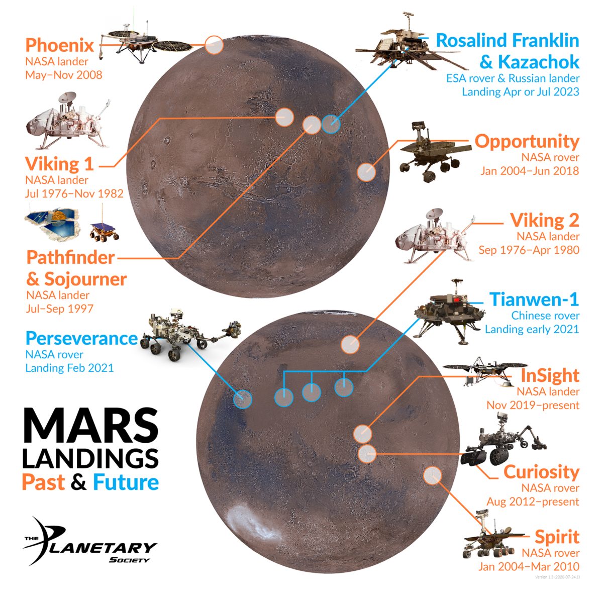
This map was a big research project, but it was actually an interim product that I made on the way to producing one that is a little friendlier for mobile viewing and social sharing. This simplified version has only the successful and future landing sites. Thanks to Planetary Society volunteer and retired Jet Propulsion Laboratory space image wrangler Sue LaVoie for helping me find or make the handy-dandy spacecraft icons.

I hope this map is useful to people, space fans and professionals alike. I’m providing it in both PNG (9.5 MB) and PDF (35 MB) form for easy, crisp printing. Enjoy!
Mars, the red planet
Mars once had liquid water on the surface and could have supported life. Scientists are uncovering how it transformed into the cold, dry desert-world it is today.
Support our core enterprises
Your support powers our mission to explore worlds, find life, and defend Earth. You make all the difference when you make a gift. Give today!
Donate

 Explore Worlds
 Find Life
 Defend Earth


