Emily Lakdawalla • Feb 20, 2014
Curiosity update, sols 540-8: New rules and longer drives
The Curiosity mission posted a newsy update yesterday regarding their future driving plans. On sol 547 they tested a new driving mode -- backwards -- and achieved their longest single-day drive in three months, more than 95 meters. Since then, they drove another 95 meters on sol 548. And they've committed to driving to the spot formerly known as "KMS-9," marking that commitment by giving it a name, "Kimberley." The route to Kimberley will take them across hopefully sandy paths in valleys among low ridges and plateaus. While stopping at Kimberley to do science, the rover team will replan the route to Mount Sharp based upon their new plan to drive Curiosity over softer, sandy terrain, which tends to occur in valleys rather than on ridges.
I've spent a bunch of time this week coming up with new ways to look at the region through which Curiosity is driving. My favorite result is the following pair of 3D route maps. I didn't mark every drive sol, just enough to indicate the path Curiosity took. I'm pretty proud of how these turned out! Here's the first part of the path:
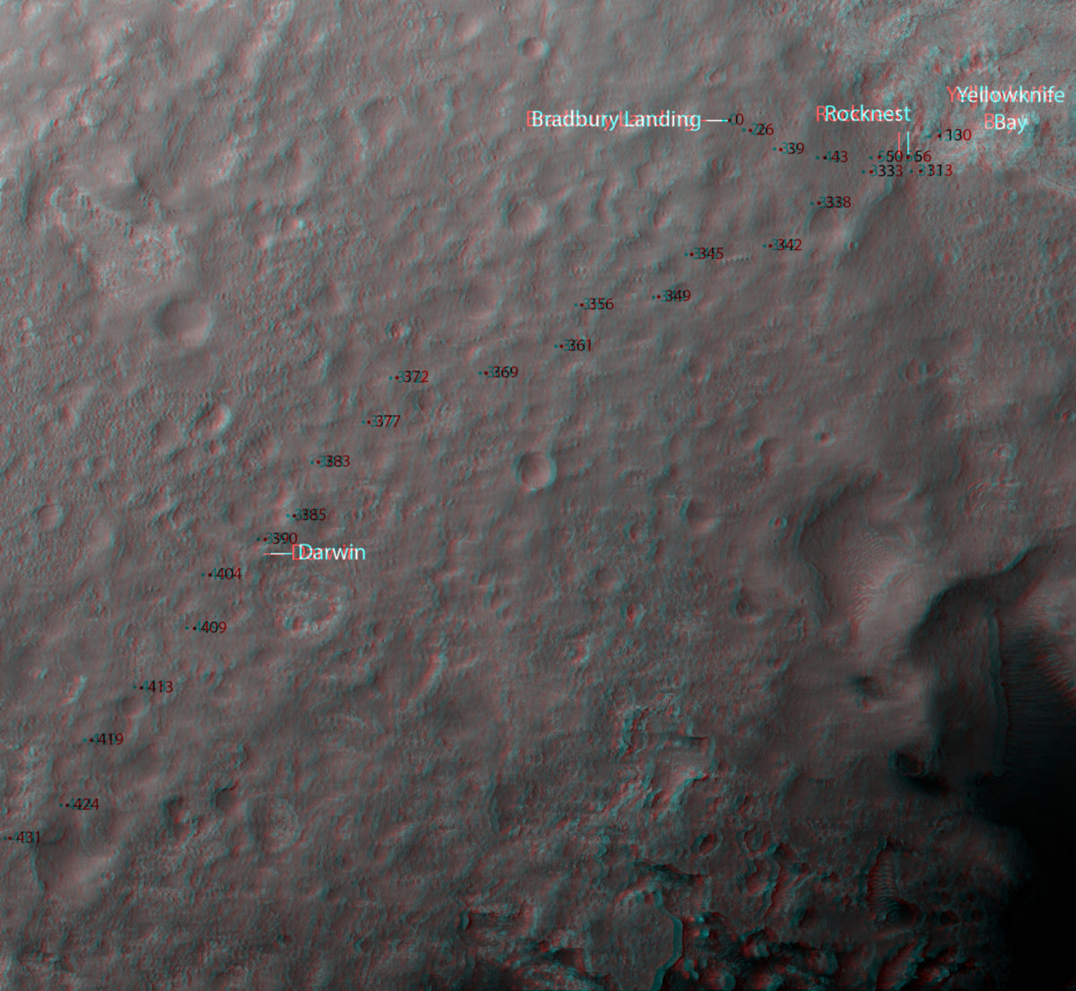
There is not a huge amount of topography in this first part -- no surprise, since we're well within the landing ellipse, a region selected to be very flat. It is nondescriptly hummocky and there aren't a lot of obviously rocky outcrops.
Things change quite a bit in this second section:
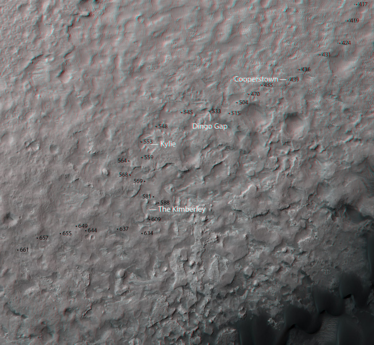
The nondescriptly hummocky stuff comes to an end; suddenly you can see a lot more rock outcrop, eroded in places to make sharp shadow-throwing ridges. Between sol 419 and 424, Curiosity starts driving onto a ridge that stands relatively high above the surrounding terrain. Then on sol 515, they stopped moving southwest, and instead went west, through Dingo Gap into lowstanding terrain.
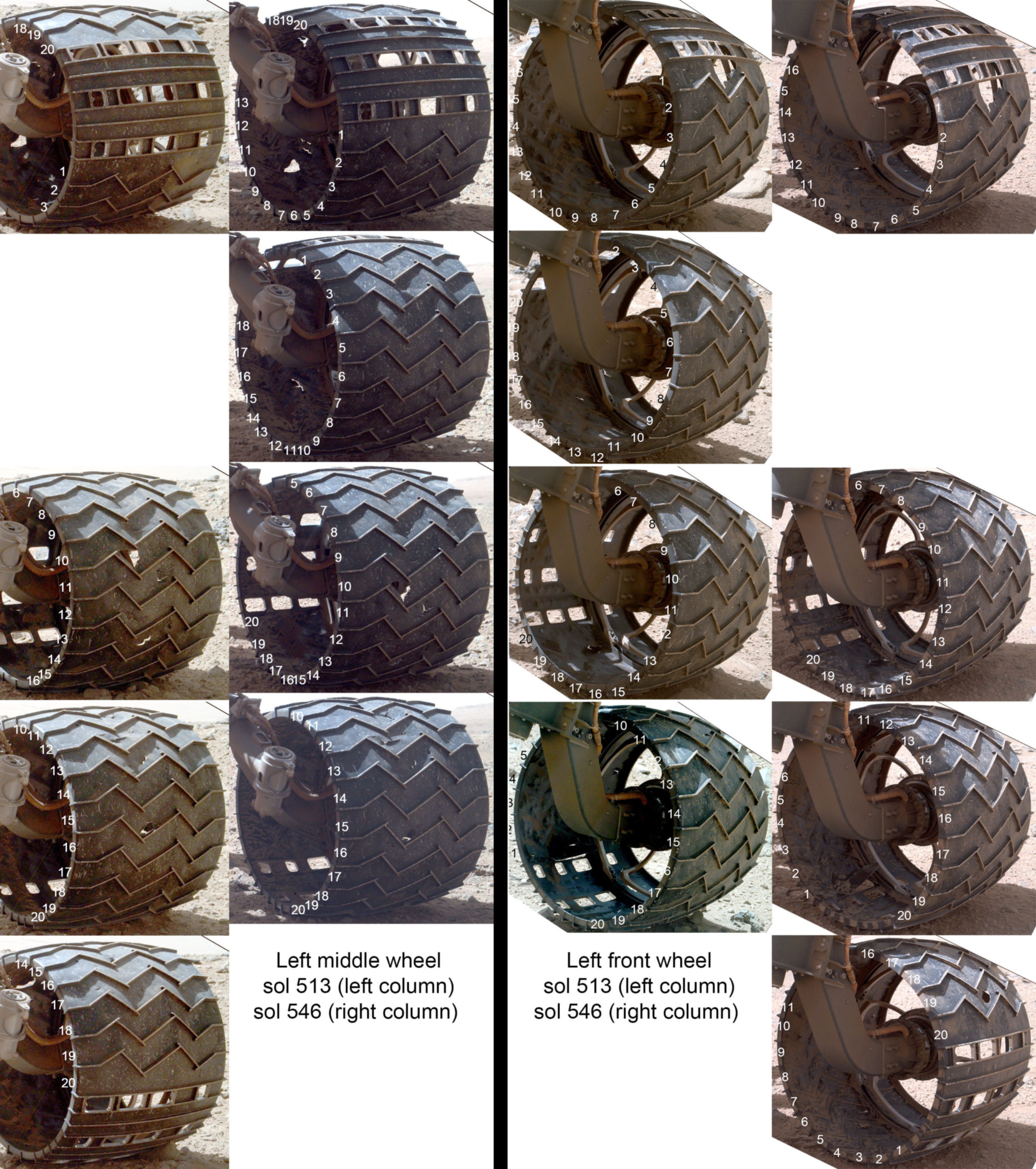
The reason for the change of terrain choice was the wheels. At the same time that Curiosity moved from the hummocky stuff onto the ridge, the wheels started taking a beating, accumulating large holes at a rate that alarmed the public and, it now appears, was a concern to the mission as well. According to yesterday's release, the strategy of driving into the valley has found terrain that is less likely to cause damage to the wheels, and they proved their regained confidence with those back-to-back 95-meter drives down the valley.
Driving backward is also helpful, according to the release. I think it's amusing that all of the Mars rovers have wound up needing to drive backwards. I actually ran across a planning document somewhere that explained that the rocker-bogie suspension system does function marginally better that way -- driving bogie first -- and that the rovers are deliberately built rocker-first so that in case they wind up in a bad situation, they will be pointed in the "better" direction to extract themselves. In any case, the three rovers wound up driving backwards for different reasons: Curiosity to prevent wheel damage; Spirit, because one front wheel had siezed up and had to be dragged behind her like a ball and chain; and Opportunity only drives backwards half the time, to help evenly distribute lubricant in the wheels. Sadly, she was driving backwards when she got embedded at Purgatory -- but that ended well, so it's all good. (UPDATE: A reader reminded me that Opportunity is now driving backwards almost all the time, because that seems to work better for her gimpy right front wheel. What is it with right front wheels? At least Curiosity is changing things up by having problems with left-side wheels.)
The release states that Curiosity won't be driving backwards all of the time, just some of the time. (The reason they wouldn't do it all the time is because the RTG blocks the Navcam's view of the terrain immediately ahead of the rover when they're driving backwards, so they will probably stick to forward as much as they can, but have backwards driving "in the toolkit," as the release says, for driving on nastier terrain.)
Anyway, the switch from ridges to valleys seems to have halted the rapid degradation of the wheels that was seen while driving on top of that ridge. The other day, they took a new set of survey images of the wheels. I looked closely at the two most damaged wheels, the left middle and left front, and saw no new big holes:
According to the traverse map posted with the mission update, they plan to stick to valley driving. Here, I've taken the traverse map they posted and plotted the same information on top of a topographic map very helpfully supplied to me by Peter Grindrod. Note that the elevation in this area is below the Martian datum -- Gale is one of the deepest holes on Mars -- so elevations are negative.
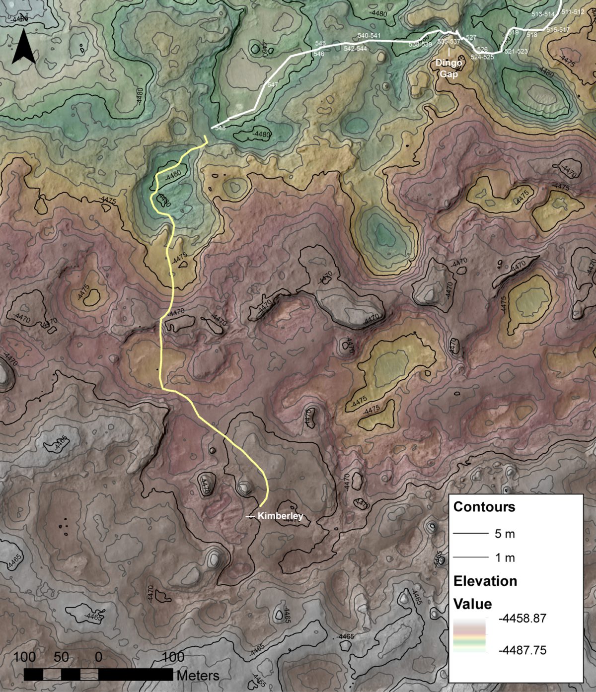
I wanted to include the contour map in part to show you that the topography isn't as extreme as the 3D anaglyph maps make it seem. The contour interval is only 1 meter; in the steepest part of the planned future traverse, I see Curiosity dropping 2 meters over a map distance of 10, for a slope of 11 degrees. In the whole image, elevation ranges over only 30 meters, from a low of -4488 to a high of -4459. So these "valleys" and "plateaus" might be better described as "swales" and "knolls."
Still, it's enough topography to have a significant effect on Curiosity's view. Curiosity is tall -- the mast puts the Mastcams and Navcams 2 meters above the ground -- but these valleys that Curiosity is driving through are more than 2 meters deep. The decision to switch from driving across higher ground into valleys will mean that Curiosity won't always have an expansive view of the surrounding terrain.
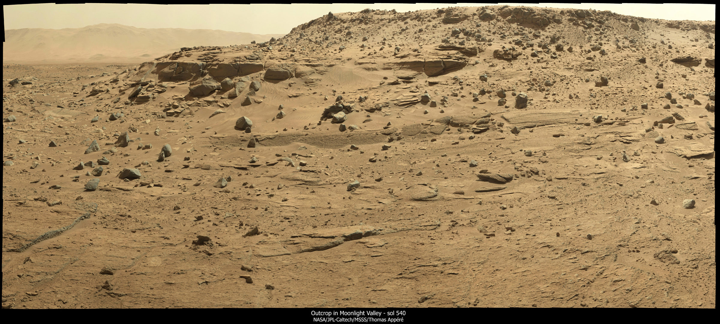
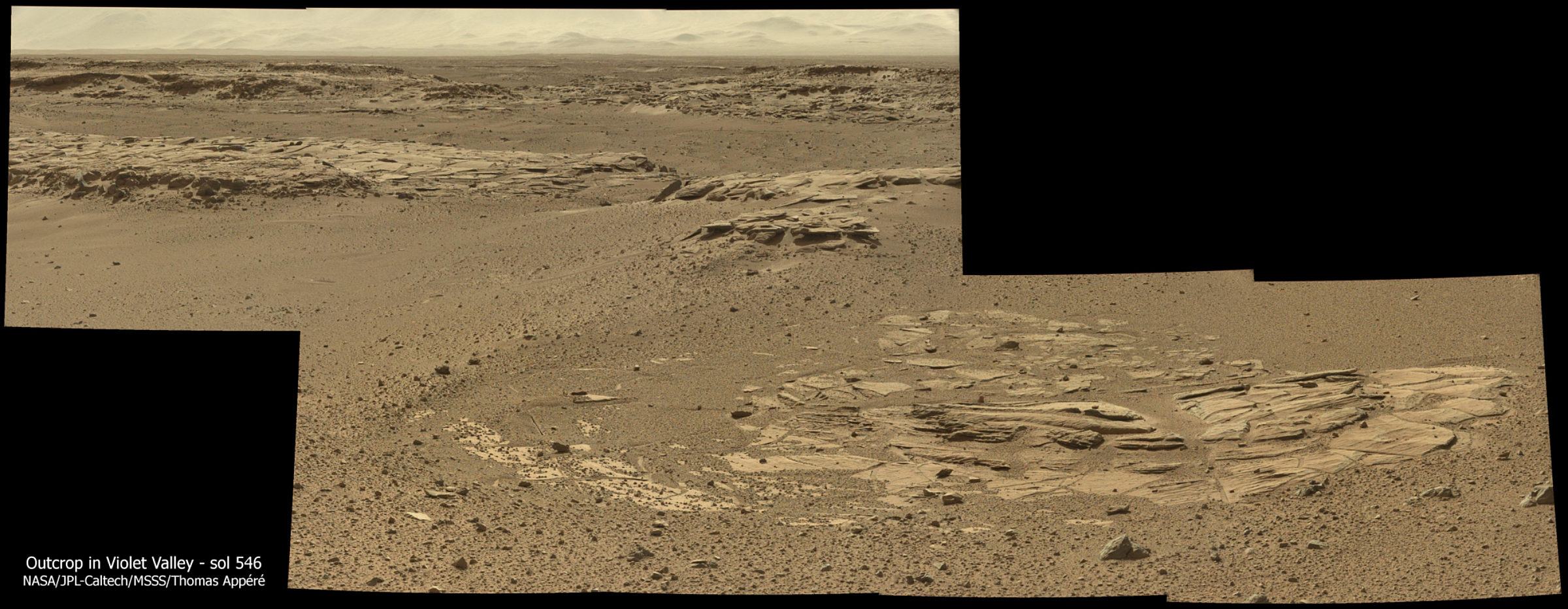
But for fans of geology, that's a good thing. Check out the views that Curiosity gets while driving down these valleys. I'll let Ken Herkenhoff talk about that:
Sol 540-541 Update from Ken Herkenhoff: Small Valley (11 February 2014)
I'm SOWG Chair today for a 2-sol plan. Planning is restricted again, as we won't receive the data from Sol 540 until late Tuesday. So we're planning a ~73-meter drive on Sol 540 and untargeted remote science on Sol 541. Before the drive, we've planned big Mastcam mosaics of the walls of the small valley the rover is in, to document the sedimentary structures exposed there. Everything fit easily into the time available, so tactical planning is going smoothly so far today.
Sol 542-543 Update from Ken Herkenhoff: Fitting Everything In (12 February 2014)
I'm SOWG Chair again for another 2-sol plan, and it's been a more hectic planning day. The Sol 540 drive went well, about 71 meters total. A shorter (~23 m) drive is planned for Sol 542, allowing some time for pre-drive targeted Mastcam stereo imaging and MAHLI images of the wheels. Because the volume of data expected to arrive in time for planning on Friday is limited, it was a challenge to prioritize all of the necessary data. Another challenge was including a Mastcam search for frost at sunrise on Sol 543 without depleting the battery too much. In the end, we got everything to fit, plus a bunch of untargeted ChemCam and Mastcam observations later on Sol 543.
Sol 544 - 545 Update from Ken Herkenhoff: Busy Before Sunrise (14 February 2014)
Another busy 2-sol plan--Sol 544 will begin with a bunch of MAHLI activities: Imaging of the inlet for SAM's tunable laser spectrometer, the standard wheel imaging, and images from various angles of a spot in front of the rover to measure the photometric behavior of the surface. The first and last activities have been desired since early in the mission, so it's good to finally plan them. After stowing the arm, Mastcam and ChemCam will observe targets "Sandy Dam" and "Nita." Before sunrise on Sol 545, ChemCam will search for condensed water. Then the rover will drive about 50 meters and take the post-drive images needed to plan a full set of wheel images on Sol 546.
Sol 546 Update from Ken Herkenhoff: Presidents Day (18 February 2014)
Monday was a holiday (Presidents' Day) for some of us, but not for the MSL tactical team. The activities planned for last weekend went well, including a 47-meter drive, so the Sol 546 plan focused on imaging of the wheels at 4 positions.
Sol 548 Update from Ken Herkenhoff: Driving Backwards (19 February 2014)
Testing on Earth has shown that driving backward should reduce wear on the front and middle wheels, so the Sol 547 drive was the first long, 100 meters, backward drive. It went very well, and the terrain ahead looks good, so another long drive is planned for Sol 548, again mostly backward.
It will be interesting to watch how the new strategy of driving in valleys plays out. They can take long one-day drives while inside valleys, but because of the limited regional view, as each valley closes up and the rover comes out of it, they'll likely have to pause at the top to take photos to plan future traverses.
According to the JPL press release, they're headed for Kimberley for two reasons. First, they are considering drilling there, as they've mentioned before. Second, the team needs time to replan the future traverse. Their original traverse plan would have stuck with ridge tops, in order to improve long-distance visibility, so the shift in driving strategy is sending them back to the drawing board to find a good path through valleys instead. A science stop at Kimberley will give the science team something to chew on while the drivers are discussing the long-term plan.
Support our core enterprises
Your support powers our mission to explore worlds, find life, and defend Earth. You make all the difference when you make a gift. Give today!
Donate

 Explore Worlds
 Find Life
 Defend Earth

