Emily Lakdawalla • Mar 14, 2011
The curse of living on a geologically active planet
As the disaster of the magnitude 8.9 Sendai quake of Friday, March 11, at 05:46:23 UTC continues to unfold in Japan, I have been unable to tear my attention away. Over the weekend I've heard much good news about the safety of many friends there, among residents, visitors, and facilities, but also much that is horrifying about the scale and far-reaching effects of just one quake on one fault among many thousands of faults that cut Earth's crust into interlocking pieces. I can't bear to watch the endless videos of the earthquake and tsunami's acts of destruction; I shy away from the cost in lives and property that each image evidences. I send my wishes for the safety of those I haven't heard from, and for all of Japan's recovery from this unimaginable disaster.
Even as my mind turns away from the human cost, I am fascinated by the geophysical observations. It's a terrible tragedy but one that we can learn from. Hopefully we here in America can learn enough from it to implement some protections in time for the next Big One that hits Los Angeles, or San Francisco, or Seattle. It's not lost on me that we are nowhere near as prepared as Japan was -- to see such a modern and forward-looking society as Japan struggling to cope with the earthquake is frightening.
As I can't seem to stop thinking about the earthquake I thought I would try to gather some links to the geophysical reports that I've found most informative. But before I do that, let me share some of what I've learned about space people and facilities affected by the quake. Spaceflight Now reported about several JAXA facilities. The greatest damage was suffered at the Tsukuba Space Center, "mission control" for JAXA missions and instruments, which is about 50 kilometers northeast of Tokyo and about 250 south of Sendai; Spaceflight Now's photos show fallen ceiling panels and overturned cabinets. NASA has temporarily taken over control of JAXA's facilities aboard the Space Station. The launch facilities on Tanegashima Island are at the southern tip of Japan, far from the epicenter, so was spared major damage and did not experience a destructive tsunami.
A commenter on this blog entry has reported that the ISAS campus in Sagamihara, which is 30 kilometers southwest of Tokyo (so on the opposite side of Tokyo from the quake) suffered minor damage but nothing serious, and no injuries were reported. I haven't heard anything yet about the Usuda deep-space communication facility, which is inland and about as far from Sendai as Tokyo, so probably felt some pretty severe ground shaking, but had no threat from tsunami.
From Bob Pappalardo I learned that there had actually been a planetary science meeting (the International Symposium on Planetary Science) taking place in Sendai during the week before the quake, which had just ended. In addition to Japanese scientists there were five western scientists presenting; I'll save you the suspense and tell you that though there was some delay in hearing from some of them, and they've not all reached home yet, all conference attendees have been reported safe. They'd dispersed after the end of the conference so it took some time to track everyone down. The western scientists were: Nick Schneider of LASP, who was on a bullet train during the quake, and who was able to text a report of his safety pretty quickly; later he confirmed that the Sendai faculty, staff, and student hosts were all OK. (I was heartened by one comment about his evacuation: "The Japanese seem to know how to handle this sort of thing.") Also in attendance were Francois Leblanc of CNRS and Helmut Lammer of IWF, who were safe in Sendai; and Jeff Kuhn of Hawaii, who had reached Narita in Tokyo. There was a frightening delay in hearing from the last western attendee, Michael Mendillo of Boston University, who was stranded with about 2,000 other people in the tsunami-struck Sendai airport for a couple of days before being able to get word to his wife that he was safe and had been evacuated to Yamagata; he should reach home tomorrow. Many thanks to Nick for his reports from the ground, and to Bob for corralling all this news.
OK. Now on to geology. I'll confine myself to two topics, then post some links to further reading. Any self-respecting planetary geologist cuts his or her teeth studying the planet that is most accessible to us: Earth. The problems that we have understanding what drives Earth's active geology are magnified when we attempt to study the geology of worlds we can't reach in person, most of whose active geology ended billions of years ago, the signs of which have decayed under eons of bombardment by meteorites large and small. Even when we study Earth, we are mostly only able to study the uppermost skin of Earth, which creates its own problems. The forces that drive geological activity on Earth are global ones -- the solidification of the inner core, the motions of the fluid outer core, the convection of the solid mantle, the motions of the plates that ride on top of the moving mantle. But we can only truly see the stuff at the uppermost surface and try to deduce from the shapes of mountains and basins, the compositions of volcanic lavas and gases, and the squiggly traces of ground motions measured by seismographs what is happening in the vast unseeable interior of our planet.
One of the aspects of Earth geology that most fascinated me is seismology, because seismology provides just about the most direct method for sensing the deep interior of Earth that there is. Consider this incredible animation of ground motions sensed by the USArray of seismometers following the quake. (It may take a while for the page to load; be patient, it's worth it.) The USArray is 15-year project that seeks to perform detailed mapping of Earth's interior using a network of 400 seismographs, spaced 70 kilometers apart, that covers about 20% of the USA at any one time, and which is slowly being moved eastward, eventually to travel across the entire U.S. Note that it took more than 10 minutes for the first murmurs of motion to reach the center of the US -- a gentle set of waves represented by pale colors, arriving from the northwest. Fifteen minutes later, the needles were set swinging much higher as more wavefronts arrived. An hour later, the sense of motion of the waves reverses -- the wavefronts now arriving had traveled westward all the way around Earth, and had traversed Africa first before reaching the US.
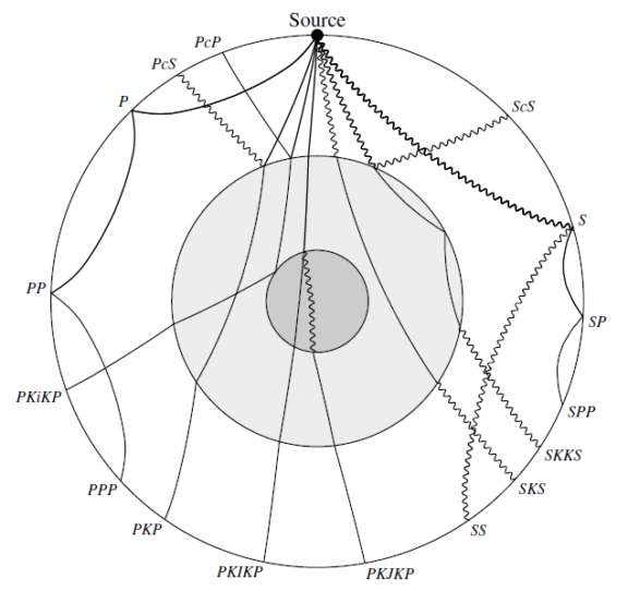
The seismogram at the bottom of the animation shows a squiggly line, labeled at five times with blue lines marking "P," "SKS," "SS," "R1," and "R2." These lines refer to the arrival of different sets of waves from the earthquake. All of these waves originated in the same original event, at 05:46:23 UTC, but because they traveled different paths as different types of waves through Earth's interior, they arrived in the USA at different times. Without going too deeply into wave theory, I'll mention that P (compressional, like sound) waves travel fastest; S (shear) waves next fastest; both of these are "body waves," which traverse Earth's interior. R (Rayleigh) waves travel along the surface, like familiar ocean waves, and are slowest but usually the most destructive. When body waves meet compositional boundaries in Earth's interior, they can reflect, refract, and turn into different wave types (P to S and S to P). In the seismogram in this animation, we see P waves, which traveled directly to the station through the mantle as compressional waves; SKS waves, which crossed the mantle as shear waves, propagated through the liquid outer core as compressional waves, then back up through the mantle as shear waves; SS, which reflected from the core-mantle boundary and back up to the station; and the first and second arrivals of Rayleigh surface waves. Timing the arrival of all these different types of waves at different locations relative to the epicenter of the earthquake provides a very detailed map of the locations and nature of all these compositional boundaries within Earth. This is why geologists would so love to get seismic networks positioned on other planets, like Mars; of course to map the deepest interior of a planet it is helpful to have very powerful earthquakes as seismic sources, something we are not sure that Mars has.

The other movie that most gripped me is this one, taken by a visitor to a park in Chiba City, located southeast of Tokyo and of similar distance to the epicenter as Tokyo. With his camera he shoots video of cracks opening and closing in the sidewalk and fields; as the cracks close you can see water gushing from beneath the surface, expelled from the soil by a process called liquefaction and thence from the ground the squeezing shut of the fissures. The commentator talks about the "whole Earth moving; I feel like I was drunk;" these are the ocean-rolling Rayleigh surface waves he's feeling.
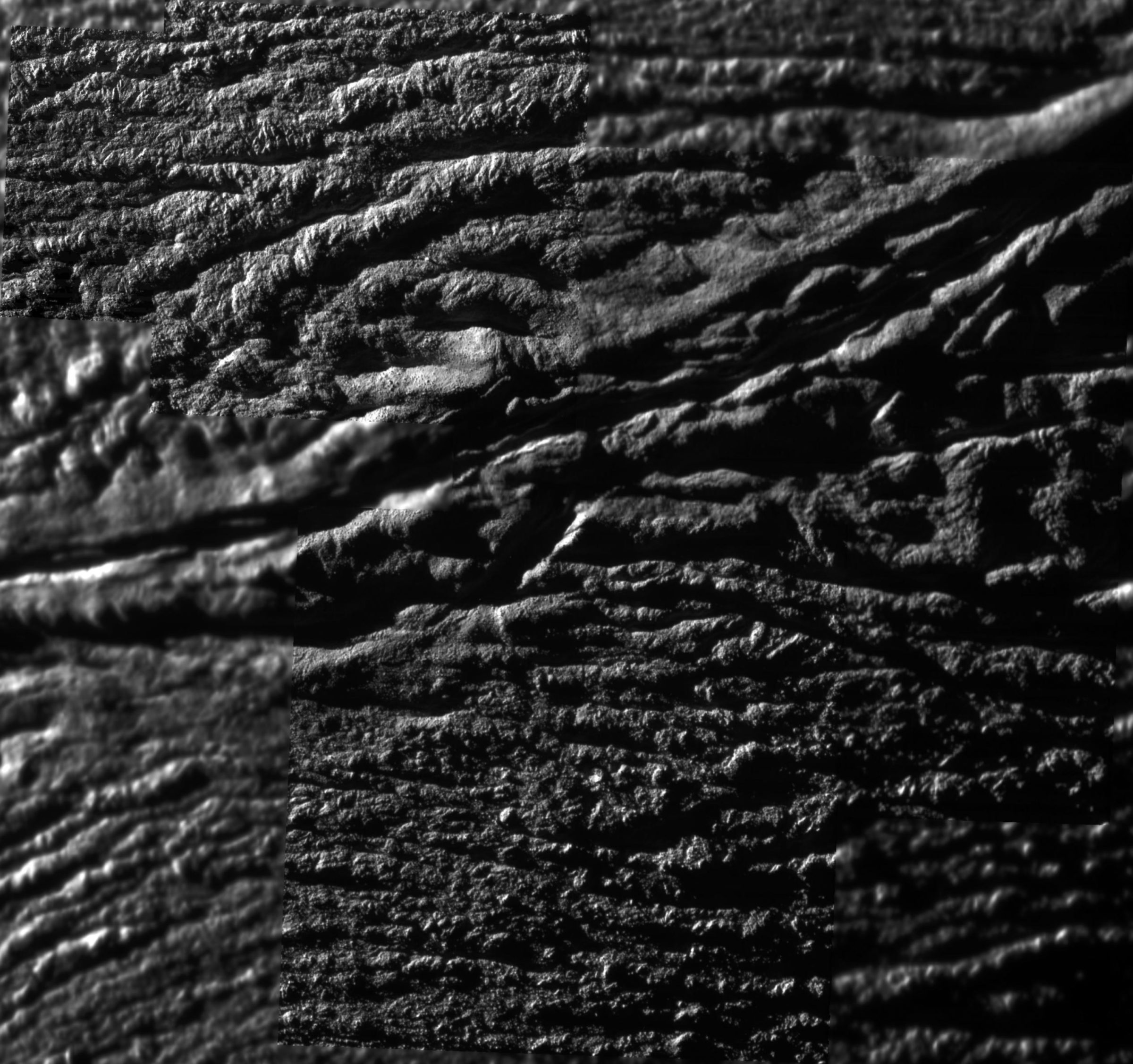
The reason I found this video fascinating is because it shows how the cracking and fissuring of a surface is an intensely local phenomenon that happens because of forces driven by global tectonics. When we study the patterns of cracks and fissures in the surfaces of icy moons like Europa, Ganymede, and Enceladus, we're seeing there the local results of global phenomena. How do you trace back from the zigzag pattern of a ground fissure to a whole moon's interior geology? It's a difficult problem.

Here are some other resources for learning about the geology underpinning the Sendai earthquake and tsunami.
- The Sendai supersite collects links to international geophysical data on the quake, from seismograms, to displacement maps, to SAR data, and more.
- The USGS has a large poster with visuals about the Sendai quake, along with a more general, thoroughly answered set of earthquake FAQs.
- IRIS has a set of "Teachable Moment" powerpoint presentations and animations to provide visual aids for anyone seeking to inform others about this earthquake and seismology more generally.
- On Twitter, Jascha Polet (@CPPGeophysics) has been doing an excellent job rounding up links to geophysical reporting. A sampling: Preliminary research results from the Earthquake Research Institute; An article on earthquake forecasting using GPS data;Kenji Satake's regional tsunami modeling animation; and his analysis of the GPS-based displacement graphs, which shows that the maximum current estimates for displacement are 403 centimeters horizontally, 70 centimeters vertically. (Ground displacement estimates are the source of those "whole island of Japan shifted 8 feet" sorts of statements you see in the media.)
A final geophysical thought: Not many rocky planets besides Earth are prone to the kind of intense near-surface earthquake-inducing ground ruptures that we have. Earth is, so far as we know, the only terrestrial body that experiences plate tectonics. Other places -- the Moon and Mars in particular -- mostly experienced a "stagnant lid" form of geology in which the uppermost surface is rigid and immoveable, where most tectonic activity would be deep-seated and would only erupt in the form of volcanoes.
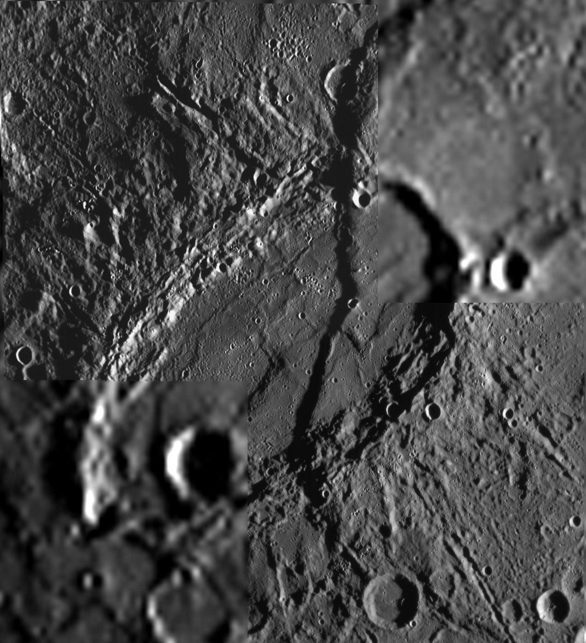
There's one interesting exception, however, and that's Mercury. Mercury has a very rigid outer crust. But it also has a gargantuan core, which is, as far as we can tell, still in the process of solidifying. It shrinks as it solidifies. The rigid surface can't just shrink; it has to buckle and fold in order to accommodate the change in shape. The way Mercury's surface does this is through the formation of thrust faults, like Beagle Rupes, below. This is the same kind of fault that underlies Japan. How many massive ancient earthquakes, how many single violent events did it take to form this one ridge shrinking one crater on Mercury? How many quakes did it take to form all the ridges all over Mercury? Are those Mercury-quakes still happening now?

I'll close by asking all readers to make a donation to disaster relief efforts at the charity of your choice. I haven't done enough research to offer advice on the best one. I will suggest, though, as an employee of a charitable organization, that you give your gift in an unrestricted fashion. Today's disaster is in Japan. But there are people still suffering from the previous large earthquakes in New Zealand, in Chile, and in Haiti, and in countless other disasters around the globe. All of these people need aid, and distributing that aid requires massive administrative effort. Unrestricted gifts permit charities to send the money where they deem it will do the most good, or to use it to fund unglamorous but necessary expenses in the home office. Do your research, select one with goals and people that you decide you can trust, then do trust them to decide how best to spend it.
Support our core enterprises
Your support powers our mission to explore worlds, find life, and defend Earth. You make all the difference when you make a gift. Give today!
Donate

 Explore Worlds
 Find Life
 Defend Earth

