Larry Crumpler • Feb 25, 2014
Field Report From Mars: Sol 3519 - December 18, 2013
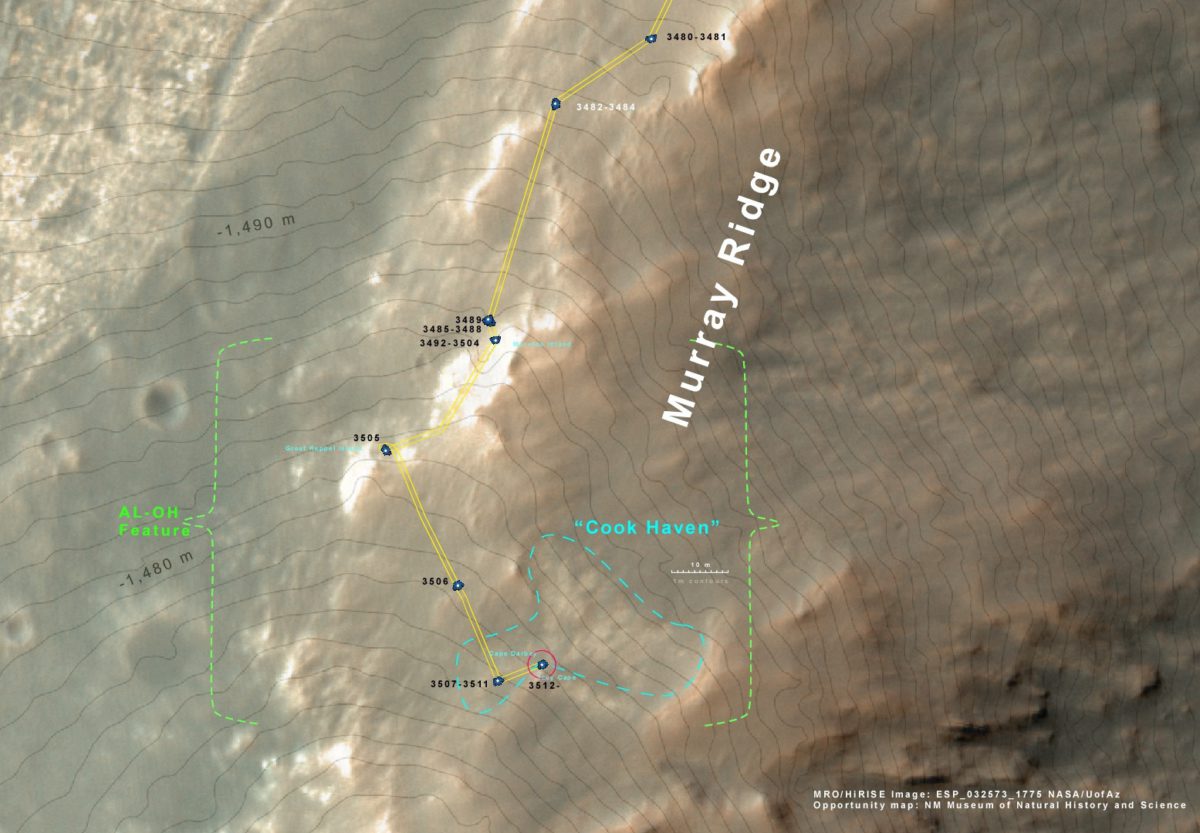
Opportunity arrived at the location that has been the target of all this climbing since late last (Earth) summer. We will settle in for some detailed work on the outcrop here since this appears to be something different from the impact breccias that we have been seeing along the ridge crest. This rock type was actually predicted to be here on the basis of orbital remote sensing. We were able to correlate the orbital remote sensing indicators of this rock type with actual "hand samples" that we looked at back at Cape York to the north. Sure enough, it appears to be here way up on the rim of Endeavour crater. We will be walking around these outcrop here during the slow time of the holidays and early winter. The outcrop area is named "Cook Haven."
This is the view taken way back on sol 3365 as we approached the rim segment named "Solander Point." On it I have plotted the subsequent traverse of Opportunity, including the ascent path along "Murray Ridge." You can see the long climb ending at our current location on the crest.

Above is the current status of the traverse plotted on a MRO/HiRISE color image. The area outlined by the blue dashed line is the area that we believe contains some unusual outcrops, maybe even rocks significantly altered by fluids. The rocks certainly look different from those we have seen along the rest of Murray Ridge. In the coming weeks we will start exploring this outcrop area as well as getting some interesting panoramas from this elevated position on the Endeavour crater rim. The 1 m contours are from stereo pairs of this area, also from MRO/HiRISE data.
Above are the east and west facing halves of the current Navcam panorama from the location as of sol 3519. It is pretty much at the contact between two rock types. The contact between the different rock types is shown by the dashed lines.
We keep track of the dust accumulation on the solar panels with the "duct factor." Sometimes the dust factor gets really low in the winter, meaning there is a lot of dust on the panels, and power gets a little dicey. Last winter it got down to 0.45. It looks like we are doing pretty well this winter. Usually the dust factor drops very slowly after this time of the year. So we should stay above 0.45 this year for sure. The dust factor goes up of course when there is a "solar panel cleaning event." usually in late spring to early summer when there are large gusts of wind.
For more discussion about Opportunity's current ascent and the naming of Murray Ridge, visit the Planetary Society web site report "Mars Exploration Rovers Update: Opportunity Ascends Murray Ridge into Clay Mineral Grounds Sols 3474 - 3502 by A.J.S. Rayl".
Support our core enterprises
Your support powers our mission to explore worlds, find life, and defend Earth. You make all the difference when you make a gift. Give today!
Donate

 Explore Worlds
 Find Life
 Defend Earth


