Emily Lakdawalla • Mar 30, 2011
Images and data now pouring in from MESSENGER at Mercury
Today the MESSENGER mission held a press briefing to show off some of the first images and other data that are streaming in from the spacecraft, now that it has entered Mercury orbit. Before I get to the more substantial stuff I'll just post my favorite image released today, a dramatically lit view of terrain near the north pole, terrain that hasn't before been viewed by a spacecraft. It's covered with secondaries; there are chains of craters; and the low lighting makes it easy to spot the characteristic undulating ridge of one of Mercury's ubiquitous thrust faults, signs that the entire planet has shrunk.

Although the camera is capable of capturing images that are 1024 pixels square, this one is only 512 pixels square. They're not holding back any data; the image was reduced in size ("downsampled") aboard the spacecraft before being transmitted to Earth in order to save on file storage space and transmission time. For their global map they don't need more data than that, not from the parts of the orbit that are near closest approach, anyway; I'm sure they're downlinking the full-resolution data from the parts of the orbit that have the spacecraft at much greater distance from the planet.
Most of the press on the phone call seem not to have paid much attention to the mission before (several of the major science reporters and bloggers I know were either not listening in or didn't ask questions), so there wasn't really much new information discussed. Just two things stuck out in my mind from the briefing. One was this slide. The data isn't really all that significant, yet. It just shows five days of measurements -- ten orbits -- from MESSENGER's magnetometer, superimposed on the previous measurements captured in all six previous flybys, by Mariner 10 and MESSENGER.
It's just the barest beginning of what MESSENGER will get in a mission lasting four Mercury years. But that five days' worth of data has already tripled the number of measurements that we've made of the planet's magnetic field, and it has also reached to the full span of latitudes never before sampled by a spacecraft. The images that we are getting now will just refine a view of Mercury that we already have developed from the previous flyby data; these magnetometer measurements are ground-breaking, resulting in an utterly unprecedented data set. The same is true for the topography data now coming in from the laser altimeter.
The other piece of information that was new concerns the color imaging of the planet. The MESSENGER camera system has an 11-color filter wheel. Initially, plans called for doing color imaging of the planet through all 11 of these filters. But the team is now planning to acquire the global color map in only eight filters. Here's a summary of those filters; I've crossed out the ones that are not being used for global mapping. (Presumably they will still be used for targeted imaging of geologically interesting targets.)
| Number | Wavelength* | Color | |
|---|---|---|---|
| 6 or F | 430 nm, narrow-band | violet | |
| 3 or C | 480 nm, narrow-band | blue | |
| 4 or D | 560 nm, narrow-band | green | |
| 5 or E | 630 nm, narrow-band | red | |
| 7 or G | 750 nm, narrow-band | near-infrared | |
| 12 or L | 830 nm, narrow-band | near-infrared | |
| 10 or J | 900 nm, narrow-band | near-infrared | |
| 9 or I | 1000 nm, narrow-band | near-infrared | |
| * narrow-band: filter allows only a small range of wavelengths to pass through (typically 5-15 nanometers) panchromatic: filter allows a broad range of wavelengths to pass through | |||
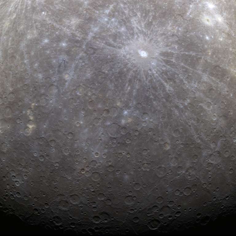
Here's the first color image of Mercury, a false-color version of the one released last night. With the benefit of infrared imaging, Mercury's surface is patterned in blues and yellows.

Support our core enterprises
Your support powers our mission to explore worlds, find life, and defend Earth. You make all the difference when you make a gift. Give today!
Donate

 Explore Worlds
 Find Life
 Defend Earth


