Emily Lakdawalla • Feb 26, 2009
Mapping Mars, now and in history
Planetary cartographer Phil Stooke has been working on a cool project to compose and compare maps of Mars that show how we saw the planet throughout the Space Age. He's been posting a lot of this work on unmannedspaceflight.com but I wanted to highlight it here because it is really exceptionally cool to see how Mars came more sharply into focus with each orbital mission.
I could present these maps in chronological order from earliest to most recent. But I think it's more interesting to start with our vision of Mars today -- based on orbital missions -- and work backward, to see the planet vanish into the murk of history. We know Mars now from orbiters, which have the luxury of sitting in place and getting repeated coverage of Mars over the course of a Martian year or more, building up enough images to compose the best possible map of the planet from pole to pole. Comparing our images of Mars from orbiters reveals changes in the positions and shapes of albedo markings (darker and brighter areas) on Mars' surface with time. Here are three global views of Mars from orbiters: Mariner 9 (1971), the twin Viking Orbiters (1975), and Mars Global Surveyor (2000).
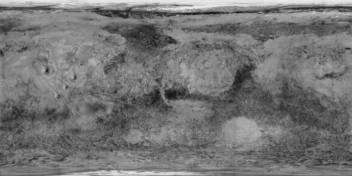
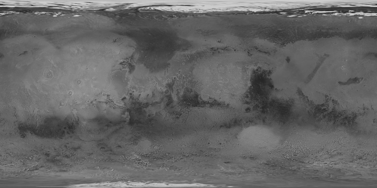
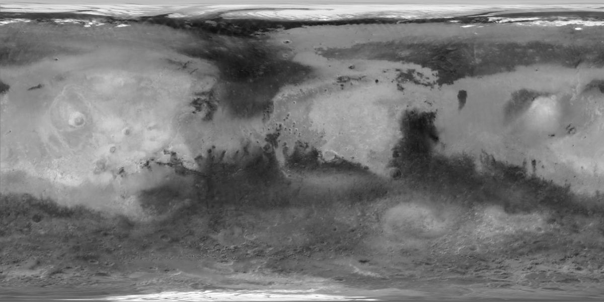
A note on the map projection used here: Phil has put them all in simple cylindrical projection, where degrees latitude and longitude make a rectangular grid -- latitude and longitude are simply x,y coordinates, so that 1 degree of latitude and 1 degree of longitude are the same height and width in pixels regardless of their position on the globe. This is a somewhat inelegant map projection that severely distorts the poles, making them spread out hugely. But it is a highly convenient projection to store digital data in; it's a handy format from which mapping software can generate any map projection you like, or from which 3D modeling software can use to wrap the map around a sphere and animate a rotating globe. The format also makes it really easy to plot mapped positions of points and features, using longitude and latitude as x,y Cartesian coordinates. So it's the most common map projection for digital data that you'll find on the Web.
Getting back to the maps: some differences in these maps result from different lighting geometry -- the Mars Global Surveyor map in particular is made mostly from albedo data captured by the Thermal Emission Spectrometer, and was intended to observe bright-and-dark variations across the surface while (to the extent possible) ignoring topography. Viking and Mariner 9 imaging was intentionally done with more shadows on the surface so that scientists could see Martian topography from the shadows cast by ridges and cliff walls. The Mars Global Surveyor map is actually the best of these to use to compare to what Earth-based viewers see of Mars through their telescopes because of its emphasis on albedo variation rather than shape-from-shading.
So we've had a pretty modern view of Mars (globally speaking) since 1971, following Mariner 9's mission. Go back a bit farther, though, and Mars begins to fade into the murk. Mariner 9 was preceded in 1969 by two flyby missions, Mariner 6 and Mariner 7. Both of these took a few dozen photos of Mars (called "far-encounter" images) as they approached, building up the data necessary for global maps, albeit low-resolution ones. They both flew past Mars' southern hemisphere, where it was summer, returning a few dozen higher-resolution "near-encounter" images; Mariner 6's course was closer to the equator, while Mariner 7 flew closer to the pole. Here is the best map of Mars that could possibly have been drawn following the 1969 missions.
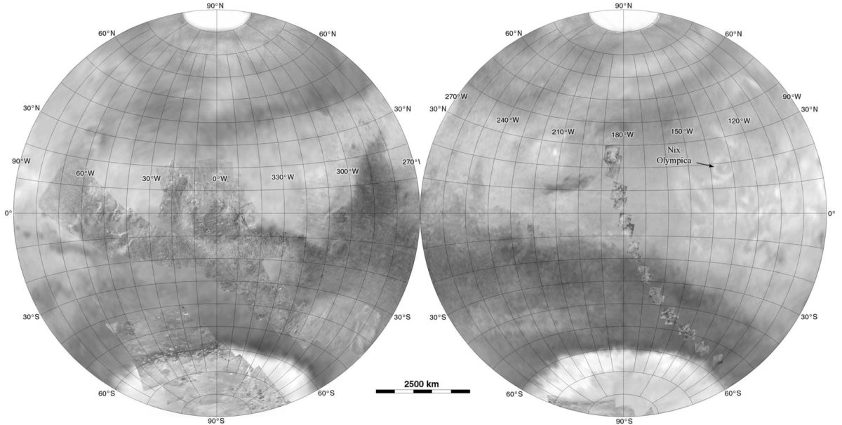
To see what some of these images look like up close, you might check out this post on the Mariner 6 and 7 view of Sinus Meridiani (which is at the center of the left-hand hemisphere in the above map); here's some thumbnail views of the entire "near-encounter" image catalog from Mariner 6 and 7.
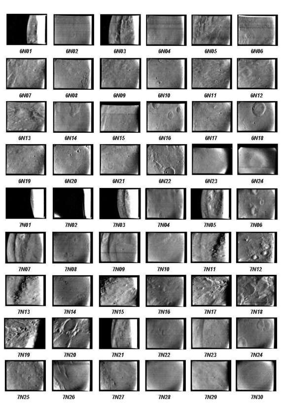
In these views, the craters of Mars are quite obvious. As for channels or other features diagnostic of more recent geology, it's harder to make a case.
Just for fun, here's two maps composed of Mariner 7 (top) and Mariner 6's "far-encounter" images.
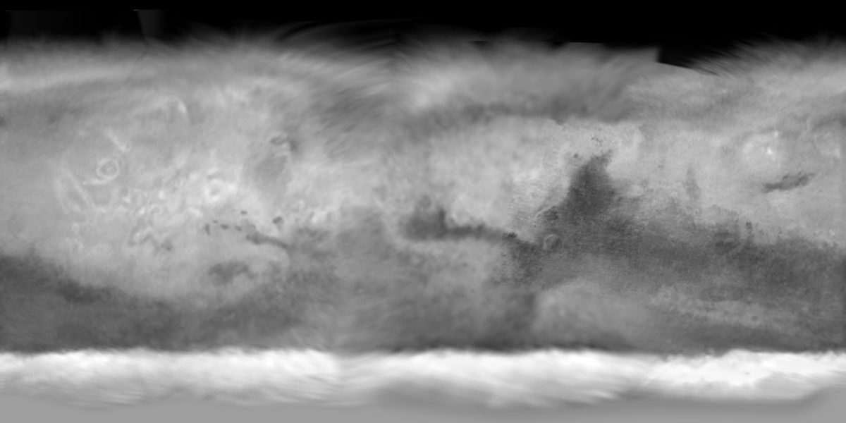
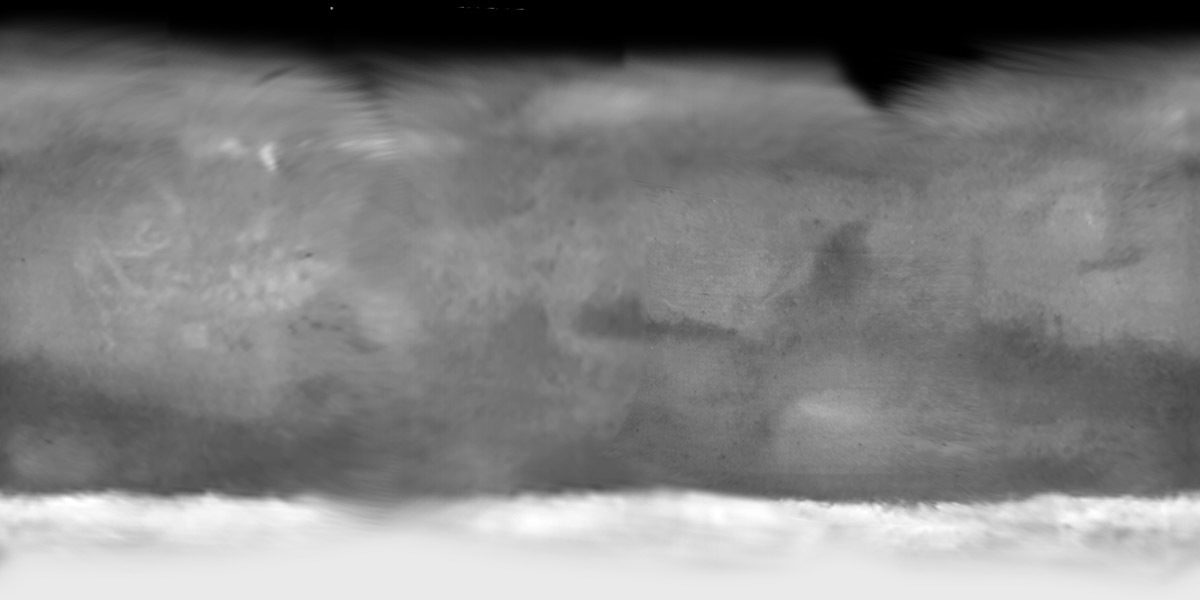
Our very first spacecraft views of Mars came from Mariner 4, in 1965. It did not capture distant images so there isn't the data necessary to produce the global views returned by its successors. Its sparse frames from Mars are included on Phil's post-Mariner 7 map above.
Here's an interesting thought: although Phil has produced each map of Mars from data available in a given year, whether it be 2000 or 1969, until relatively recently the people who worked on the missions or behind the telescope and produced the data from which Phil composed his maps didn't have the tools necessary to produce maps of the quality that Phil can produce. The "mosaics" of images from the Mariner missions (to Mars as well as Venus and Mercury) were composed into larger maps and panoramic views by a process that often literally involved making a mosaic of individual photographs: photos were printed out, cut out, and then stuck down on a larger sheet (or sometimes a spherical surface) to make a collage. Throughout the first half or so of the space age, the best maps of the worlds of the solar system were not made from the actual images shot by spacecraft, but were actually drawn by artists, who used the images and collages as guides to draw seamless composite images in beautiful shaded relief. (If I'm not mistaken, that's the method by which the Mariner 9 map at the top of this article was produced.)
Now, though, just about any household computer has the power (if not the software) necessary to take in a bunch of individual image files, combined with detailed information about the position of the spacecraft that took them, along with the position, size, and shape of the target planet, and warp each image as necessary to correct for the shifting of the spacecraft's position and the rotation of the planet. This process is called reprojection, and when it's done correctly, mapmakers like Phil can tile numerous images together to produce maps the likes of which the original mission scientists could only dream. (In practice, it's not at all easy; knowledge of the spacecraft's position and planet's shape are never perfect, and there's a lot of twisting and tweaking that has to be done to each image to make a seamless mosaic. It's still almost as much art as science.) So although the maps above show how we could have seen Mars following the Mariner missions, in reality our view wasn't that clear.
OK, so let's go back a bit further. What did Mars look like to us before Mariner 4 lifted off? At the beginning of the 1960s, our best knowledge of Mars came from telescopic observations. Now, there are lots and lots of historical Mars maps to choose from, but the one below is the most relevant one to include here because it was made by the United States Air Force, used in planning for the Mariner 4 mission. Are you ready? Behold:
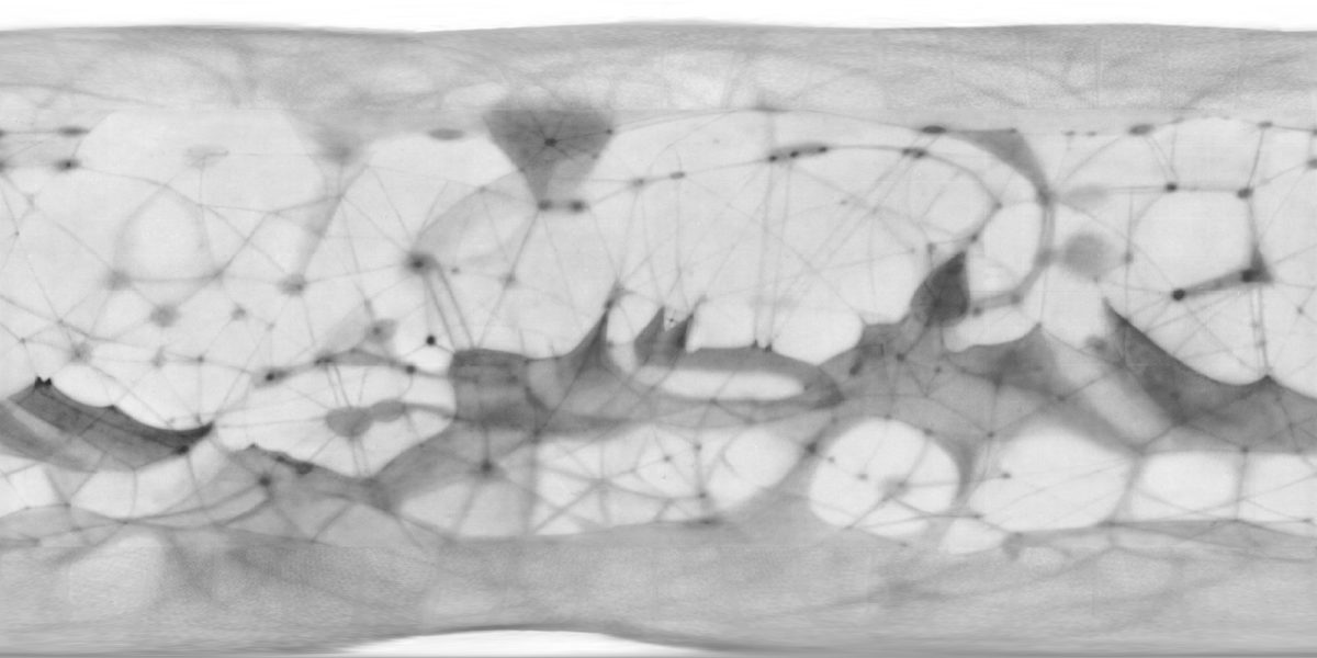
Canals?! Yes indeedy, this map includes lots and lots of canals, straight lines connecting darker spots that some (but most certainly not all) astronomers saw through their eyepieces as they gazed at the red planet. Phil informs me that, in fact, most astronomers of the time did not believe these canals existed, but there were a few people (notably the eminent American astronomer Earl Slipher, who died just a few years before Mariner 4 launched) who included them in their maps, and who clearly influenced the Air Force's map of Mars.
That's almost all the stuff that Phil has massaged into shape to post so far; there is more to come, notably from the Russian Mars missions. But here's one more gem. He's dug up one of the earliest maps of Mars, composed of observations made over multiple nights so that it covers the entire globe. It was made by William Herschel in 1783.
The shape of Sinus Meridiani and Sinus Sabaeus at left will be familiar to Mars viewers. The bulge above it is Syrtis Major, not as pointed as in the USAF map, and the triangle at the bottom is probably Lunae Lacus, or a confused combination of that and Margaritifer Sinus. The hook shape at the top is Thoth-Nepenthes.
Support our core enterprises
Your support powers our mission to explore worlds, find life, and defend Earth. You make all the difference when you make a gift. Give today!
Donate

 Explore Worlds
 Find Life
 Defend Earth

