Emily Lakdawalla • Mar 10, 2008
Reporting in from LPSC
This is just a brief post from Houston to say I'm here and covering what I can from the first day of the Lunar and Planetary Science Conference. I've already taken lots of notes on the morning's session on MESSENGER at Mercury. (Here's a program and abstracts for that session in PDF format, about 6 MB.) There's nothing Earth-shattering (Mercury-shattering?) to report from the presentations given so far, but they are beginning to dig in to the details of trying to figure out the history of Mercury's geology from the wonderful new MESSENGER data set. Some of the best news of the morning was in Maria Zuber's talk on the Mercury laser altimeter. That instrument builds up topographic information on Mercury by firing a laser at the surface several times a second and watching for the return flash. They only had one profile on Mercury from the flyby, but during that profile they were able to detect return flashes from angles of up to 70 degrees off of nadir. Let me explain what that means.

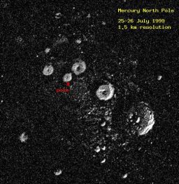
J. Harmon, P. Perrilat, and M. Slade
Radar image of Mercury's north pole
Arecibo Observatory S-band radar image of the north polar region of Mercury. The image measures 450 kilometers (280 miles) on a side. The bright features are bright to radar and could be ice deposits on permanently shadowed crater floors. However, not enough is known about the radar properties of surfaces that have been extremely cold for billions of years for this to be a certain conclusion.There's no Internet access available inside the conference halls, so I am not sure when I will be able to post again today -- I may be taking lots of notes and digesting over the course of the next few days. But I'll do my best.
Back to the sessions!
Support our core enterprises
Your support powers our mission to explore worlds, find life, and defend Earth. You make all the difference when you make a gift. Give today!
Donate

 Explore Worlds
 Find Life
 Defend Earth

