A.J.S. Rayl • Jan 08, 2013
Mars Exploration Rovers Update: Opportunity Zeroes In on Clay Minerals and We Look Back on 2012
Sols 3149 - 3178

Mars Exploration Rover
NASA / JPL-Caltech / Maas Digital
Despite the lull of the holidays, the Mars Exploration Rover (MER) mission recorded one of the expedition's best months ever in December as Opportunity and her team confirmed the location of the smectite clay minerals on Matijevic Hill, effectively grabbing the scientific brass ring they came hoping to find at Endeavour Crater.
The smectites, which are in a class of water-altered minerals known as phyllosilicates, have been hiding right out in the open in the recessed, flat, light-tone outcrops that feature a dark coating or rind, tiny veins, and a sprinkling of a new kind of small spherules. Known as Whitewater Lake outcrops – named after the first such rock the rover checked out last September – these distinctive rocks belong to a single unit or layer forming the rim of the crater that happens to be the oldest rock layer Opportunity has ever encountered, the MER science team has determined.
"We have concluded the Whitewater Lake unit has got to be the one that contains the clays," said Steve Squyres, MER principal investigator, of Cornell University during a recent interview.
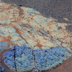
A Whitewater Lake rock
This picture shows one of the light-tone, flat Whitewater Lake rocks that are harboring the smectite clay minerals the MER team came looking for at Endeavour Crater. The rover saw these flat, light-tone rocks all around her in mid-November as she completed her survey Matijevic Hill. The Pancam team processed this picture in false color to better show the dark coating or rind that immediately set these stones apart.NASA / JPL-Caltech / Cornell / UA

Cape York from CRISM
This image is actually a geological and mineralogical map of Cape York taken by the Compact Reconnaissance Imaging Spectrometer for Mars (CRISM) instrument onboard MRO. The location of the clay mineral signatures CRISM detected are displayed in red. Stuart Atkinson, of UnmannedSpaceFlight.com, plotted Opportunity's path, which is overlaid here in yellow. The large red patch toward the bottom of the image is the "sweet spot" where Opportunity located the clay minerals. For more of Atkinson's work, please visit his The Road to Endeavour blog.NASA /JPL/ UA / JHUAPL / S. Atkinson
MER science team members are still in the midst of the arduous process of sorting through the rover's data and differentiating the layers on Matijevic Hill in an attempt to unravel the mystery of the area's environmental history.
They knew going in that Endeavour Crater is a Noachian Period impact. The Whitewater Lake unit is "probably" Noachian, said Squyres, but the team cannot yet say that for sure. If it is, that means the Whitewater Lake rocks date back some 3.7 billion to 4 billion years ago when Mars was warmer and wetter and more like Earth.
Locating the smectite is one of the most important scientific achievements on Opportunity's long list of accomplishments. But the rover and her team may well not have zeroed in on the smectites without a little help from a "friend" in the form of the Compact Reconnaissance Imaging Spectrometer for Mars (CRISM). This visible-infrared spectrometer onboard the Mars Reconnaissance Orbiter (MRO) searches for mineralogic indications of past and present water on Mars and several years ago, it detected the specific signature for smectite from Matijevic Hill, in the Cape York segment of Endeavour's western rim.
The CRISM detection of smectite at Endeavour Crater was, actually, "the biggest push" in the team's decision back in September 2008 to head out from Victoria Crater on what turned out to be a three-year, 21.5-kilometer (13.35-mile) journey across the Meridiani Plains for the really big hole in the ground, recalled John Callas, MER project manager at the Jet Propulsion Laboratory (JPL), home to the American Mars rovers.
Given that CRISM discovered the presence of clay minerals, Opportunity's assignment was to ground-truth their location, to characterize their hosts, and determine the geologic setting. But with its two mineral detecting instruments no longer working, the rover "cannot independently confirm the mineralogy of the Whitewater Lake outcrops," reminded Ray Arvidson, MER deputy principal investigator, of Washington University St. Louis (WUSTL).
The scientists must – with data collected by CRISM in hand, along with the rover's multitude of images – infer the location of the smectite. "What we have found is, if you map very carefully the clay-bearing signature from orbit – and Ray has done this very well – you find that it coincides really quite well with the exposures of Whitewater Lake that we see on the ground," said Squyres.
"The smectite area as seen from CRISM correlates 1-to-1 with the outcrops of Whitewater material," elaborated Arvidson, who spent more than a year painstakingly putting all the pixels from the CRISM data onto a HiRISE map, and then overlaying it onto Cape York, research he presented earlier at the annual American Geophysical Union (AGU) meeting in San Francisco in December. "There's no other mineral that I can think of that would produce that signature we see from CRISM except smectite, and it's exactly where Whitewater Lake is."
From first sight back in August of this year, Whitewater Lake looked like nothing before seen on Mars. "The whole ensemble of data we've collected with Opportunity shout out that Whitewater Lake is among the most special deposits we've seen," said Arvidson. "It's got this darker, purplish coating on it. It's very fine-grained and cut through with veins. It's recessive and erodes pretty quickly. And, it has more silicon and aluminum than many places we've seen. All of that says that Whitewater Lake is special."

NASA / JPL-Caltech / Cornell / ASU / S. Atkinson
Whitewater Lake rocks host clay minerals
This mosaic of several separate images shows a number of the Whitewater Lake rocks that surrounded Opportunity in November. These rocks, the scientists determined in December, are the source of the smectite clay mineral signature that the CRISM instrument onboard the Mars Reconnaissance Orbiter detected several years ago. Stuart Atkinson processed this mosaic to bring out textures and shapes on and around the rocks.During its survey of Matijevic Hill that followed in October and November, Opportunity encountered more Whitewater Lake-like slabs, recessed into the hill. By Halloween, the robot field geologist was working on an up-close examination of one of them.
Since clay minerals form in water that is neutral to alkaline, different than the highly acidic past water for which Spirit and Opportunity both found substantial evidence, documenting and understanding the geologic context for the smectite is scientifically revealing. "Clay minerals form when you have water with a relatively neutral pH," said Squyres. "There are a lot of different ways to make clays, but clays don't form under highly acidic conditions. So the presence of clays points to watery condition with a chemistry that would be more favorable for life than a highly acid chemistry."

From Eagle to Endeavour
This image of Endeavour Crater was taken by the Malin Space Science Systems' Context Camera onboard the Mars Reconnaissance Orbiter (MRO). The yellow line on this map shows the route Opportunity took from Eagle Crater, where the robot field geologist landed in January 2004 (at the upper left end of the track) to a point about 3.5 kilometers (2.2 miles) away from the rim of Endeavour Crater. The rover arrived at the rim of 22-kilometer (14-mile) diameter hole in the ground in August 2011, after a three- year journey from Victoria Crater. The rover entered by way of Spirit Point, an area named after her twin "sister," which stopped communicating in March 2010.NASA /JPL-Caltech / MSSS
Although both Squyres and Arvidson have "made the call," the inferred finding of the smectites still must still go through the traditional peer review process before it's official. By any account however, this is remarkable science coming nearly nine years into a mission "warrantied" for 90-days.
Meanwhile, Opportunity finished downlinking the last of the images for the Matijevic Panorama, now being processed by panoramic camera (Pancam) lead and Planetary Society President Jim Bell, of Arizona State University. And, after completing work on the second Whitewater Lake rock, the rover moved a little further up hill and into another mystery at Copper Cliff, a formation that looks vaguely like a bench one would sit on.
From a distance, Copper Cliff looked to have a breccia-like appearance and the MER science team thought it might be like, or of the Shoemaker Formation unit. Once Opportunity got there however, they thought differently. The rover homed in on a target on Copper Cliff that the team named Onaping, using its microscopic imager (MI) and alpha particle X-ray spectrometer (APXS), an instrument that determines the elemental chemistry of rocks and soils using alpha particles and X-rays.
"Copper Cliff has newberries, and a composition different than anything we've seen so far," Arvidson expounded. "It has a very low iron content and, because of the low iron content, you can't make it by mixing any combination of Whitewater and Shoemaker to make Copper Cliff. So it's yet something different." Squyres concurred: "It's a puzzling outcrop and we're still working our way through this," he said.
Copper Cliff had also been alluring to the science team because it featured a solid contact or boundary area between strata or layers. It turned out not to be the boundary they were looking for – between the Shoemaker Formation, which formed the scientists believed in an impactite event, and the ancient Whitewater Lake unit.

Opportunity at Copper Cliff
Opportunity snapped this picture with her front hazard-avoidance camera (Hazcam) on her Sol 3163 (Dec. 16, 2012). It shows the rover's instrument deployment device (IDD) or robotic arm at work on Onaping, a target at the base of an outcrop called Copper Cliff in the Matijevic Hill area of the west rim of Endeavour Crater. This outcrop turned out to be "yet something different" than the other outcrops the rover has found so far at Endeavour Crater, according to Ray Arvidson, MER deputy principal investigator.NASA / JPL-Caltech
Instead, it was the contact between the Whitewater Lake unit and the Copper Cliff material, which is "sitting on top of it," said Arvidson. "It's a very clear and abrupt contact," said Squyres. And, it's the first of what should be a number of key boundary discoveries that will enable the MER science team to unravel the layers at Matijevic Hill, and delve chronologically back into Endeavour Crater's geologic history.
Toward the end of December, Opportunity bumped up to the top of Copper Cliff, to a small slice of light-tone bedrock dubbed Vermilion. "The top of the outcrop is another recessive bright bedrock that is kind of tilted up the hill," Arvidson said. "Vermilion is very fine-grained, and has newberries and what appear to be breccia fragments."
Although it looked at first like Vermilion might be the sought-after contact or boundary between the Shoemaker Formation breccias and the Whitewater Lake unit, it turned out not to be. "Vermilion is not the contact, so it must be further uphill," Arvidson reported.
Opportunity's work has really just begun at Matijevic Hill and the rover is facing an agenda full of scientific assignments, including: finding the contact between Shoemaker Formation and the Whitewater Lake unit rocks; characterizing the composition of the tiny veins cutting through Whitewater Lake rocks; and resolving the mini-mystery of the new kind of spherules, the newberries, as Squyres dubbed them. All of which will help the team sort out Endeavour's past.
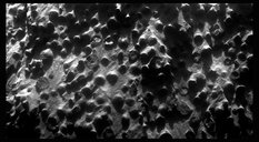
Newberries
Opportunity took the pictures that went into this close-up mosaic with her microscopic imager (MI) on her Sol 3064 (Sept. 6, 2012). This mosaic combines four images, and the view covers an area about 6 centimeters (2.4 inches) across, at an outcrop called Kirkwood in the Cape York segment of the western rim of Endeavour Crater. The individual spherules are up to about one-eighth inch (3 millimeters) in diameter. Stuart Atkinson processed the raw data, enhanced it, and produced this striking picture that shows the berried newberries that has the scientists shaking their heads. For more of Atkinson's work, please see his Road to Endeavour blog.NASA / JPL-Caltech / S. Atkinson
Backstage, so to speak, there are enough dueling hypotheses about what Opportunity is seeing and the data it is returning that it's obvious the geologic history of Matijevic Hill is a work very much in progress.
The newberries, for example, are clearly different than the "blueberries" Opportunity found all throughout her traverse across Meridiani Planum; nevertheless, they could still be concretions "lightly glued together with something not seen before," as Squyres put it. Or they could be lapilli, little volcanic hailstones, spherical accumulations of ash that form in debris clouds that develop during volcanic explosions. Or they could be impact spherules, or devitrification spherules formed of glassy material that crystallizes into spherical structures.
Although most science team members have their own personal favorites, the team has yet to agree and settle on one. "We're keeping open a bunch of different hypotheses," said Squyres. And, it's important to note that as intriguing as the newberries were to the scientists from the moment saw them and checked them out in August and September, Opportunity has yet to revisit them, mostly because the rover spent most of October and November conducting a survey of Matijevic Hill.
"There's a lot going on here and there's a lot that we still don't know," Squyres underscored.
Opportunity, for her part, is "doing well," reported Callas. The sky over Endeavour has been pretty hazy, corresponding to the measurement of atmospheric opacity or Tau that rose in December. But the haze comes with the Martian spring, as the winds whip up columns of dust that can turn into storms that cut local or regional swaths, and on occasion encircle the entire planet.

NASA / JPL-Caltech / Cornell / ASU
A view of Matijevic Hill 3D
On the horizon in the right half of this panoramic view is Matijevic Hill, named in commemoration of Jake Matijevic, a JPL pioneer in creating robots to rove on Mars. The view appears in three dimensions when viewed through blue-red glasses (red lens on the left). Opportunity snapped the images that are combined into this view with the navigation camera on her Sol 3054 (Aug. 26, 2012), just a couple of weeks after she pulled up to the western rim of Endeavour Crater. The left side of the panorama shows portions of the rim farther south.Fortunately, the seasonal storms have kept their distance from the rover, but Opportunity has been feeling the fallout of their dust. When the powdery material accumulates on its solar panels, the layers of dust reduce the amount of sunlight the rover can transfer into power. Even so, the rover's energy levels hovered around 530 watt-hours throughout December, which is still more than half full capability, and plenty of power for the rover to drive and continue sleuthing the scientific clues that tell of Endeavour's deep past.
As Opportunity and the MER team closed out another year and close in on their 9th anniversary in January, they already have achieved their primary objective at Endeavour Crater finding the smectite clay minerals – and in the oldest rocks the rover has ever encountered. But there are places to go and things to see on Matijevic Hill and beyond to the south, at Solander Point and Cape Tribulation.
Once the investigation of Vermilion is finished, the rover that likes to rove will be roving again. "We have a long list of things to do here," said Squyres. "We'll be moving on soon."
Opportunity from Meridiani Planum 2012 in Review
When 2012 rang in on Opportunity's Sol 2822 at Meridiani Planum – the rover's 2,822nd Martian day in operation – the robot field geologist was hunkered down at Greeley Haven, working on her winter science campaign. "It's astonishing to me that we're still going after eight years, and every day is a wonderful gift at this point," said Squyres then.
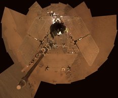
A dusty Opportunity
Opportunity's self portrait shows the dust accumulation on her solar panels as the MER mission approached its fifth Martian winter. The dust reduces the rover's power supply, and mobility is limited until the winter is over or wind cleans the panels. This is a mosaic of images that the rover took with her panoramic camera (Pancam) from Sols 2811 to 2814 (Dec. 21 to Dec. 24, 2011). The portrait is presented in approximate true color, the camera team's best estimate of what the scene would look like if you were there.NASA / JPL-Caltech / Cornell / ASU
Opportunity had been exploring Cape York since crossing the boundary from the plains on Sol 2681 (Aug. 9, 2011). Once considered a dream destination, Endeavour became real when the rover drove onto the rim of the massive 22-kilometer (14-mile) diameter crater more than seven years after bouncing down on Mars and scoring "a 300-million-mile hole-in-one," and some 33 kilometers of driving.
Although this winter was Opportunity's fifth Martian winter, it was the first for which this MER had to park on a north-facing slope, angle her solar arrays toward the winter Sun. This strategy enabled the rover to conserve power and wait out the harsh season, when temperatures could dip, even at the rover's equatorial location dip below the -63 Celsius average across the Martian surface (-81.4 degree Fahrenheit), and far below the balmy high of 20 degrees Celsius (68 Fahrenheit) at Meridiani.
But so far, even as the temperatures fell, Opportunity was managing to continue working from her parked position on Shoemaker Ridge, the geologic formation that is the spine of the Cape York segment of Endeavour Crater's western rim. As impressive as it was 8 years in, it is remarkable when one considers that every night the robot turns off her heater, as she has since January 2004. Somehow, it had become stuck in the 'on' position and was draining her power, so shutting it down at night was the workaround. So far, so good.
Opportunity was so far producing enough energy to work nearly every sol and was focused on three primary assignments: 1) a radio science study that would allow scientists to better deduce the make-up of Mars' core; 2) taking the hundreds of pictures needed for the full-scene, 360-degree, color Greeley Panorama of her surroundings; and 3) an exhaustive study of breccia bedrock on which she was parked, but managed here and there to work in other little assignments.

Opportunity at Greeley Haven
This simulated view of Opportunity is embedded in a real Navcam panorama. Rendered by Michael Howard of Midnight Mars Browser fame, it shows the rover in her approximate parked position at Greeley Haven on the northern end of Cape York, where the robot field geologist waited out her fifth Martian winter.NASA / JPL / M. Howard
But as January turned to February at Meridiani Planum, the pace began to slow and the rover began to "feel the pinch of energy," reported Arvidson, who was overseeing the winter science campaign. Opportunity was sporting a coat of dust so thick she blended into the terrain. The thicker the Martian dust on the rover, the less sunlight penetrates the arrays. That translates to less power generated by the rover.
Still, this rover aimed to please and pressed on. The Red Planet seemed to reward her for the effort, offering up a gust or two of dust-clearing winds, noticeably boosting her power levels to nearly one-third of full capacity.
As Mars reached aphelion, the farthest point in its orbit from the Sun – about 249,209,300 kilometers or 154,851,480 miles – on February 15th, Opportunity was performing above and beyond her call of duty. In addition to working on her three primary assignments, the rover also began taking a series of close-up images of the bedrock on which she is parked, as well as dramatic, Ansel Adams-like landscape photographs with her Pancam.
"Life is good," said Squyres. It was about to get even better.
March literally blew in as another series of gentle dust-gusters cleared off more of the accumulated dust from the rover's solar arrays. The gusty sols gave Opportunity a measurable "bump" in power, lifting her levels noticeably to a solid one-third capability, allowing the team to breath easy for the next couple of months, at least as far as power levels go, as Mars orbited closer to Earth than it had been in 26 months.
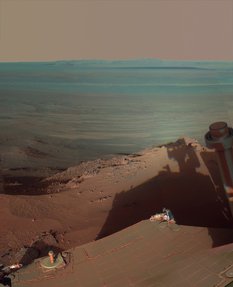
A late afternoon at Greeley Haven
Opportunity catches its own late-afternoon shadow in this dramatically lit, false color view eastward across Endeavour Crater on Mars. The rover used her Pancam between about 4:30 and 5:00 pm local Mars time to record the images taken through different filters and combined into this mosaic view. Most of the component images were taken on the rover's Sol 2888 (Mar. 9, 2012) during the low-solar-energy weeks of the Martian winter at Greeley Haven. Note the dark sandy ripples and dunes on the crater's distant floor.NASA /JPL-Caltech / Cornell / ASU
The point of minimum solar insolation – the time of the least sunshine in a Martian year –– technically the sol the ops team looked most forward to getting beyond – passed on March 9th-10th. Winter solstice was next.
In terms of work, March was a near duplicate of February, as the rover focused on her three primary science assignments and working in anything else she could, as she could. The month was becoming so routine, that by mid-month it was threatening to become boring. Then, sometime between March 15th-20th, Opportunity's left front wheel moved. While it was parked. Whoa.
It seemed to have happened right after Opportunity's instrument deployment device (IDD) or robotic arm stalled while she was preparing for an MI picture assignment. The MER ops team began investigating both anomalies. All's well that ends well. "Nothing that indicates any change in the health or the stability of the rover," Callas summed up.
While projections had estimated that Opportunity's power levels would drop down to less than one-quarter its full capability in March, the winds of Mars changed, and the rover was able to work nearly a full schedule throughout the month.
During the final week of March, as winter solstice – the time at which the Sun at noon appears at the lowest altitude above the horizon – came and went in the southern hemisphere of Mars, the team breathed another collective sigh of relief, even though it would still be a while before spring 'bloomed.' "Things will continue to be really cold for a while yet," Nelson said. "But I think we'll get through this winter just fine."
When April dawned on Meridiani Planum, Opportunity was in the thick of finishing her winter science campaign. Perhaps by way of celebration, Mars whipped up a few more small dust-gusters throughout the month to help the rover energetically shake off winter, and be empowered to labor on. Work the robot field geologist did, devoting the most of April to completing the winter campaign. Everyone seemed happy.

NASA / JPL-Caltech / Cornell / ASU
The Greeley Panorama
This full-circle scene combines 817 images that Opportunity took with her Pancam. It shows the terrain that surrounded the rover while it was stationary for four months of work during its fifth Martian winter. The rover took the component images between its Sols 2811 (Dec. 21, 2011) and Sol 2947 (May 8, 2012)."The data meet our expectations," said JPL's Bill Folkner, the radio science experiment's lead scientist. "We are finding that calculating the effect due to the motion of the high-gain antenna more complicated than we expected, but are confident that we have enough information in hand to meet our needs."
The bedrock investigation turned up breccia data the science team fully expected, while the Greeley Pan and the rover's Ansel Adams-like landscapes spoke for themselves, each a picture worth more than a thousand words.
By month's end, Opportunity had achieved its main science objectives at Greeley Haven, and then some. Best of all, "winter is in our rear view mirror," Callas announced. "I'm glad this winter is not as bad as first feared," Nelson added, speaking, no doubt, for everyone on the team. "Although," he cautioned quickly, "you never want to relax your guard with Mars."
In May, as the rover strolled out of her winter haven to continue her expedition around Endeavour Crater," Squyres announced: "Opportunity is on the road again."
The rover's first drive since December 26, 2011 was a short, 3.67-meter (12-foot) jaunt off the 15-degree northern slope at Greeley Haven on May 8th, followed by several more drives heading north along Cape York on the outside of the western rim of Endeavour Crater.As the Mars Odyssey orbiter relayed the data confirming Opportunity's completed first drive and it appeared in the rover mission control at JPL, the MER operations team offered up cheers and fist-pumped 'Yes's' with the news.
"There was definitely a positive upbeat feel to the day," said rover driver Ashley Stroupe, of JPL. "We had done a really detailed science campaign at the winter site, but we pretty much exhausted what we could do there. We were all anxious to be able to move on and there was a real air of excitement and happiness that day."
Summed up Callas: "Opportunity is the rover that likes to rove and we're happy to be back doing what we were meant to do – which is drive."
Not surprisingly, the rover literally drove out of May, heading to the northeast for 36 feet (11 meters) in search of another vein like Homestake, but one that was large enough to could dig into and examine with her APXS. Although Opportunity was producing an ample amount of power of around 366 watt-hours, the operations team was still somewhat concerned and continued to direct the rover to keep her arrays angled to the north whenever possible. "The attitude was to take it slow and find more of veins," said JPL's Matt Keuneke, one of the rover's mission managers.
The robot field geologist soon stopped at one of many veins she and her team could see in the Bench or apron that bordered Cape York and the team nicknamed it Monte Cristo. "It looked very much like Homestake," said Squyres. "Unfortunately, we were unable to RAT it, because it's surface configuration was not right."
On June 5th, the MER team and Mars aficionados everywhere lost an icon, a voice, and a friend in exploration when science fiction author Ray Bradbury died. He was 91.
The author of more than 27 novels and story collections, including The Martian Chronicles, Fahrenheit 451, Dandelion Wine, and Something Wicked This Way Comes, and more than 600 short stories, Bradbury also wrote the screenplay for John Huston's classic film adaptation of Moby Dick, adapted 65 of his stories for television's The Ray Bradbury Theater, and won an Emmy for his teleplay of The Halloween Tree. More than 8 million copies of his works, published in 36 languages, have been sold around the world and he won countless awards over the years, the 2000 National Book Foundation Medal for Distinguished Contribution to American Letters, the 2004 National Medal of Arts and a 2007 Pulitzer Prize Special Citation among them. As the New York Times saw it, he was "the writer most responsible for bringing modern science fiction into the literary mainstream."
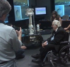
Bradbury roves on Mars
During JPL's celebration of MER's fifth anniversary celebration on Jan.15, 2009, Ray Bradbury was treated to a tour of rover mission operations by rover drivers Ashley Stroupe (behind Bradbury) and Scott Maxwell (obstructed, on the left). And he got to drive on Mars – something he never did on Earth. Bradbury passed away on June 5, 2012 at the age of 91. For all those Earthlings wh o rocketed on his words to Mars, his passing left a void that will likely never be filled.Steve Squyres
Bradbury "died peacefully" at his home in Los Angeles, following a lengthy illness, according to a written statement released by his publisher, HarperCollins. And people everywhere reacted. "For many Americans, the news of Ray Bradbury's death immediately brought to mind images from his work, imprinted in our minds, often from a young age," President Obama said. "His gift for storytelling reshaped our culture and expanded our world. But Ray also understood that our imaginations could be used as a tool for better understanding, a vehicle for change, and an expression of our most cherished values. There is no doubt that Ray will continue to inspire many more generations with his writing."
Bradbury once told his friend and biographer Sam Weller that the best description of his career as a writer was: "'At play in the fields of the Lord.'"
An original thinker, a predictor of things to come, and a writer who just had an incredible, fantastical way with words, Bradbury was, simply, one of the most imaginative, creative, and loving human beings who has ever played in the 'Lord's fields.'
Just a few days later, the Mars Odyssey orbiter – Opportunity's main data relay link – went into safe mode. That meant the rover's data sending and retrieving opportunities were limited, so what Opportunity could get accomplished was limited. It gave the rover the chance to take in her surroundings and she snapped dozens of images with her Pancam and took other measurements and close-up images of targets chosen by the scientists. Even before Odyssey was back in service, Opportunity was driving on, heading further north along the geologic bench that borders Cape York North looking for another target.
But the Odyssey event caused the rover's ops team a bit of a scare. Birth, life, death. It is the cycle of life for both humans and machines. The Odyssey orbiter has worked at Mars longer than any other mission in history and is way past its prime. But its day had not yet come.

Mars Odyssey
Mars Odyssey, which has worked at Mars longer than any other spacecraft, is the main data relay link for Opportunity and an unsung "hero" among Mars spacecraft. The orbiter suffered safe modes and had to go through a "brain transplant" and employ a spare wheel in 2012, but it's still "delivering the mail" as John Callas, MER project manager, put it as well as conducting its own research.NASA / JPL-Caltech
The Odyssey orbiter team successfully managed to bring their spacecraft out of safe mode in 9 days, though full recovery required another 10 days. Opportunity and the MER team persevered with periodic MRO passes, and even a Mars Express demo pass that returned data, along with direct-to-Earth communications, reported Nelson.
Thanks to a spare wheel that had been waiting 11 years to be put to use, Odyssey was back in action Wednesday, June 27th. The orbiter immediately picked up data from Opportunity, from her position at a rock outcrop called Grasberg, at the north end of Cape York. But noted Keuneke then: "This last month proved just how much we rely on Odyssey."
In the end, June was "a good month," if "a slow month," Keuneke summed up. No one was complaining. All the little dust-gusters served to push Opportunity's power levels upwards of 550 watt-hours. That's well more than half the 950 watt-hours of power she had the day she fired up the engines, so to speak, after landing in 2004. Actually, said JPL's Julie Townsend, rover planner, "the dust cleaning was the big news of the month."
On July 2nd, Opportunity quietly guided her team and MER followers everywhere into Sol 3000, the 3,000th Martian day of exploration, as she continued her investigation of Grasberg. "Unbelievable," enthused Squyres.
Meanwhile, the rover's power levels rose even higher, upwards of 575 watt-hours, under exceptionally clear skies. By July 10th, Opportunity was back on the road, roving toward one of a trio of small craters for a drive-by photo shoot.
From there, the robot headed back and slightly west toward a fracture or cut the team dubbed Whim Creek, located on the northern tip of the Bench bordering Cape York. "Back on the road again is what July was all about," Arvidson said. "It's good to be moving again, good to be collecting data in different places and doing lots of science these days," added Squyres.
The winds of the Martian spring whipped up a couple of storms that briefly darkened the skies over Endeavour Crater in July. "It's what happens on Mars in the spring," reminded Arvidson. One storm came within 360 meters (0.22 of a mile) of Opportunity mid-month, but neither it, nor the one that followed 12 days later, hit the rover's immediate site and both dissipated quickly. In the whirling winds, a couple of tiny gusters whisked another fine layer or two of accumulated dust from its solar arrays but the rover's power levels actually dropped slightly as the haze overhead thickened and the dust began to fallout and back onto the rover's arrays.
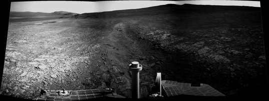
NASA / JPL-Caltech / Cornell / ASU / S. Atkinson
Whim Creek
Opportunity took the pictures that went into this image in July. Stuart Atkinson processed into this black and white panorama for the MER Update. For more of Atkinson's work, visit his Road to Endeavour blogOpportunity stood down for Martian days nine or sols in early August so that all of her orbiter and deep space network communication systems could be utilized for the arrival and check-out of her new sibling Curiosity. Then the robot field geologist roved on, driving along the northwestern rim of Endeavour Crater and around the northern tip to head south.
During the last week of the month, a wild, sinuous, fin bearing outcrop caught the MER scientists' collective eye. "We might have to slam on the brakes and take a hard right," Squyres said just before the Science Operations Working Group (SOWG) meeting on August 23rd. Opportunity did just that, heading west to the outcrop the team dubbed Kirkwood and into the “sweet spot" of a clay mineral hunting ground on a rise that overlooks the 22-kilometer (14-mile) wide Endeavour Crater. This is where CRISM found the subtle but authentic signature for the clay mineral smectite, said Arvidson who is also a co-investigator on the CRISM team and who had been studying that orbital data for months.
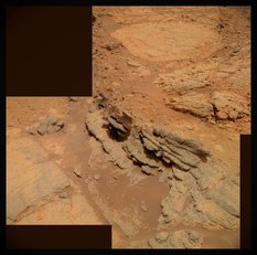
Kirkwood – Whitewater Lake
Opportunity took the images for this rich photograph of her September 2012 worksites. In the middle of the picture, you can see a part of the layered, sinuous-shaped outcrop the team dubbed Kirkwood. Just behind it, in the top part of the image is the fainter, circular, "slabby" flatter rock called Whitewater Lake, which the MER scientists concluded is part of a larger unit and the bearer of the phyllosilicate or smectite clay mineral signature detected by the Compact Reconnaissance Imaging Spectrometer for Mars (CRISM) onboard the Mars Reconnaissance Orbiter.NASA / JPL-Caltech / Cornell / ASU / S. Atkinson
"The whole science team is excited," said Nelson. "It’s like watching popcorn pop."
Keeping to its tradition of initiating a new naming theme at every new site, the team decided to christen everything in the hillrise area for sites and formations in and around the Sudbury Basin in Canada, one of the oldest and largest impact craters on Earth.
With two critical instruments out of commission, confirmation of the presence of the clay minerals won't come easy for Opportunity and her team. "It's going to take a lot of detective work," said Arvidson. "It’s really trying to understand Mars and its past history. This is a campaign that will take weeks and weeks," he predicted.
"The point is not to confirm there are clay minerals are there," reminded Squyres. "We know they're there. The point is to see what there is to see why they're there, and how they got there."
Along the way, Opportunity crossed another major milestone in August, ticking off 35 kilometers (21.74 miles) on her odometer, putting her within "striking" distance of the rover distance record, currently held by Lunokhod 2, the Russian Moon rover that logged 37 kilometers (about 23 miles).
Despite Opportunity's noteworthy achievements, the loss of Jake Matijevic, a pioneer in building rovers to explore Mars, cast a pall that would linger over the MER and Curiosity rover teams. One of the creators of Spirit and Opportunity, Jake, had a lot to do with Spirit and Opportunity becoming the rovers we know and love. He was on the original design team and led the MER engineering team for several years before and after the twin rovers' respective landings. At the time of his unexpected death on August 20th, at the age of 64, Jake was chief engineer for surface operations systems for Curiosity.
"If there is one person who represents the heart and soul of all three generations of Mars rovers – Sojourner, Spirit and Opportunity, Curiosity – it was Jake," noted Callas.
"Jake was a brilliant and sweet person, and extremely self-effacing," said Rob Manning, the MER entry, descent, & landing system manager and chief engineer for MSL/Curiosity. "I felt extremely comfortable knowing Jake was [here] doing all he could to understand the rovers and understand ourselves as well. I miss him."

Jake Matijevic 1947-2012
Jacob "Jake" Matijevic, one of the original Mars rover pioneers. He worked at NASA's Jet Propulsion Laboratory (JPL) since 1981 and was involved in the creation and success of every American Mars rover. He led the engineering team for the first Mars rover, Sojourner that landed in 1997; was a member of the original group that proposed MER and then led the engineering team for Spirit and Opportunity for several years before and after their landings. And at the time of his death in August, he was chief engineer for surface operations systems for Curiosity.JPL-Caltech
There isn't likely a person who knew Jake who didn't, and doesn't, feel the same. And so while the MER team wanted to honor Jake, it had to be someplace "really special," said Squyres. Within a few weeks, the science rich area, the "sweet spot" for clay minerals, proved to be that really special place and now it will forever be known as Matijevic Hill.
September was all about science with Opportunity roving right into another Martian mystery at Kirkwood, where it discovered a new kind of tiny spherules or "berries" – densely packed into the outcrop, and scattered all around it. Squyres promptly dubbed them "newberries," because they were nothing like the hematite "blueberry" spherules that Opportunity found shortly after landing and all throughout her expedition across Merdiani Planum.
"These are something different," Squyres, said. Measuring as much as 3 millimeters (one-eighth inch) in diameter, they appear to be "crunchy on the outside, and softer in the middle," and different in concentration, structure, distribution, and composition from the blueberries. "We have a wonderful geological puzzle in front of us," he said.
One possibility is that the newberries are concretions, but of a different kind than the hematite blueberries. Another theory is that they were formed by an impact, and not necessarily from whatever made Endeavour Crater. Or they could be accretionary lapilli, little volcanic hailstorms that form in the clouds of debris that develop in a volcanic explosion. “Pompeii is buried in the stuff,” Squyres pointed out.
Cool as the newberries were, there was a lot of cool, unusual stuff within Opportunity's view. So, the robot field geologist moved on, just around and behind Kirkwood to another unusual rock target, a bright, light-tone outcrop marked with tiny veins and "splashes" of a darker overcoat or rind, a flat rock the team christened Whitewater Lake. The robot field geologist immediately gave it a quick in-depth examination with her cameras and her APXS.
With the focus heavy on science, Opportunity didn't really drive much in September, but that would soon change. Once the robot field geologist completed her close-up inspection of Whitewater Lake, she shifted into recon-mode, embarking on a survey Matijevic Hill in mid-October, looking for the most scientifically compelling geologic formations to revisit for in-depth studies.
"A reconnaissance of the site is the first thing you do in geologic fieldwork, and that's what we're doing," Arvidson explained then. "We've done the initial reconnaissance on Kirkwood and Whitewater Lake and now we're going to walk around the site, just like a geologist would."
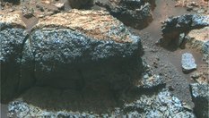
Newberries in false color
This Pancam mosaic shows part of the Kirkwood outcrop in false color to better distinguish the rock's features. Kirkwood, a wild, sinuous outcrop that sports fins, is what drew the MER science team members, along with the CRISM findings, to Matijevic Hill. This is the outcrop where the rover first found the new kind of spherules, or "newberries," as MER Principal Investigator Steve Squyres dubbed them. They are not the same as the hematite "blueberries" the rover found previously, and as of yet, the scientists don't know what they are. This photograph was processed by the Pancam team at Cornell and Arizona State University (ASU).NASA / JPL-Caltech / Cornell / ASU
Taking a counterclockwise route from Whitewater Lake, the rover headed out on a north/west/south/east loop around the hill, taking short jaunts of 10 to 30 meters, documenting her path and just about everything interesting around it in pictures
During the survey trek around the hill, Opportunity roved naturally into a routine, driving up to a spot, taking a full 360-degree panorama with the navigation camera, and then on the next plan [sol or day] it would take some Pancam images of the next spot before driving on. "When we're done, we'll have this very extensive, very complete dataset of this whole area from which to pick out the high value targets to then examine in more detail later on," noted Callas.
Since the MER team has been fully incorporating orbital data from the HiRISE camera onboard MRO into its planning, there's a lot less mystery involved in choosing the rover's routes. “HiRISE imagery is an integral part of the planning now, both scientifically in terms of mapping out strategic plans for where we want to go, and tactically," said Ed Guinness, of WUSTL.
After spending the last half of October driving around and taking pictures on Matijevic Hill, Opportunity hunkered down for Halloween and spent the holiday quietly, staying out of mischief's way.
In early November, Odyssey underwent what is effectively "almost like a brain transplant," as Callas put it. It's what they call a 'side-swap' in rocket scientist jargon, and involved the orbiter switching its relay system from Side-A to Side-B, which is a redundant or spare system. The operation took the orbiter out of relay commission for several days, so Opportunity turned her UHF radio toward MRO to downlink her data to Earth. By November 11th, Odyssey was back to "delivering the mail every single day," Callas reported.
Even before she had gotten all the way back to Whitewater Lake to actually complete the rectangular shaped "circle" the scientists had drawn around Matijevic Hill, the team declared Opportunity's survey done in mid-November. Since the rover was surrounded by outcrop rocks that looked just like Whitewater Lake, the MER science team decided that their field geologist should sample a different one. "We are trying to see how extensive areally this Whitewater Lake material is, because it's the one unit that is big enough and compositionally the best bet to hold the smectite signature that we're seeing from CRISM," Arvidson explained.
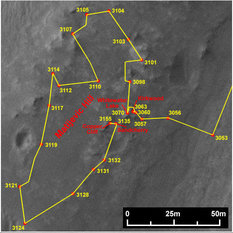
Opportunity's route around Matijevic Hill
This map shows Opportunity's travels around Matijevic Hill, up to Sol 3155 (Dec. 8, 2012), when it stopped to check out Copper Cliff. It shows the rover's approximate current location on Matijevic Hill. This image was produced by Eduardo Tesheiner, of UMSF.com, who created it from images taken by the HiRise camera onboard the Mars Reconnaissance Orbiter.NASA / JPL / UA / E.Tesheiner
Opportunity brushed the notorious Martian dust off the target Sandcherry on the new Whitewater Lake-like rock and then grinded into it with her rock abrasion tool (RAT), just about a millimeter. The rover took pictures and chemical measurements, with her MI and APXS respectively, after each action. The rover also methodically snapped hundreds of pictures with her stereo Pancam to be processed into the next big picture, the Matijevic Panorama.
Throughout the month, Opportunity performed flawlessly, skirting danger from a storm that ultimately kept its distance, passing to the south of the rover and never getting any closer than about 1300 kilometers (807.78 miles).
As November turned to December, the robot field geologist finished her work on the Matijevic Panorama, then wrapped up her close-up look at Sandcherry. From there, she moved just 23 centimeters (9 inches) to reach some new surface targets.
Members of the science team, including Squyres and Arvidson, had already concluded that the Whitewater Lake rocks were the hosts of the smectite. The clay minerals had all but welcomed the rover and her team to Matijevic Hill back in September.
Opportunity moved on, just 2.2 meters (7 feet) to the west, up hill, to approach Copper Cliff, where science team members could see a distinct contact or boundary between geologic units. The rover then "bumped" 3 feet (1 meter) closer to a candidate surface target, the team nicknamed Onaping. There, she took the requisite pictures for an MI mosaic of that surface target and then followed that task with the usual APXS overnight integration to analyze the elements of Onaping.
"Onaping is actually an interesting puzzle because it doesn't quite look like Whitewater Lake," said Squyres. "It certainly doesn't look like anything we saw in the Shoemaker Formation. And it's hard to make it by mixing the materials we've seen. The interesting thing is that when you look at the MI images of Onaping and other portions of Copper Cliff, it clearly has newberries in it. And so we suspect that the process that formed Onaping and the other stuff around it, basically all the rocks of Copper Cliff probably had to do with Whitewater Lake type rocks being fragmented and jostled around and somehow busted up by the Endeavour impact event. But we're still working on the details," he said.
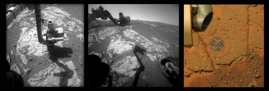
NASA / JPL-Caltech / Cornell / ASU / S. Atkinson
Brushing Sandcherry
In this series of images, you can see the "fruit" of Opportunity's labor in November 2012 on a target called Sandcherry, on one of the Whitewater Lake rocks the rover found all over Matijevic Hill. The robot field geologist used her RAT to brush and then grind into the target and the weird coating or rind that seems to be splashed on these flat, light- tone rocks. This series comes courtesy of Stuart Atkinson, of UMSF.com.On Sol 3160 (December 13, 2012), Opportunity began taking images with her MI for another mosaic of a surface target, but partway through the activity, the her robotic arm experienced a stall in her shoulder azimuth joint. The engineers on the ops team have seen this stall a few times before, almost always when the arm is commanded to move at a slow rate, as explained in the last MER Update.
The engineers at JPL directed Opportunity through a series of diagnostic activities on Sol 3162 (December 15, 2012) to confirm the joint is OK. They then had the rover place the APXS in a spot offset from the original and everything went as expected.
"Things always slow down a little over the holidays, but the focus has been on starting to work through our list of things to figure out from the Matijevic Hill survey," said Squyres.
During the third week of December, Opportunity bumped about 5.5 meters (18 feet) to the west to reach a new set of surface targets in the Copper Cliff area and then continued her close-up, in-situ investigations there through the Christmas holiday.
"One of the things that was among the highest on that list was – is Whitewater Lake older than or younger than the Shoemaker Formation breccia materials and we're pretty definite now that it's older," Squyres informed. "That really helps to constrain the history here. It means that the Whitewater Lake unit is the oldest stuff Opportunity's ever seen."
Opportunity and her team were hoping the contact they spied at Copper Cliff represented the definitive boundary between Whitewater Lake and the Shoemaker Formation. "But that is not what we've found here," said Squyres. "What we found are busted up rocks that have a number of Whitewater Lake-type characteristics, including newberries, and a somewhat different chemistry from Whitewater Lake, and we're still puzzling over it," he continued. "But we have not found a simple contact between Whitewater Lake and Shoemaker Formation impact breccias."
Opportunity moved again last week to spend the long New Year's weekend at a small bright outcrop just above Copper Cliff, called Vermilion, which the scientists thought could be sought-after contact between the Shoemaker Formation breccias and the Whitewater Lake rocks. It wasn't, said Arvidson.
As 2012 faded to history, Opportunity's odometer read 35,438.37 meters (35.43 kilometers or 22.02 miles). It was producing 542 watt-hours of power, and reporting a Tau of 0.961 but an improved solar array dust factor of 0.633. Despite the dusty skies overhead, the robot field geologist's future looks as bright as it possibly could for the veteran rover.
Once Opportunity's work at Vermilion is finished, the science team will choose the next target for scientific inspection. "We have lots of images from the walk-about and we will try to find the best places to do those things, but we have not chosen all of them yet," said Squyres.
If all goes as planned however, Opportunity will be driving on soon – to its next destination, as well as its next anniversary.
Looking Back on 2012
Looking back, the MER scientists and engineers agree that 2012 was, all things considered, a very, very good year for Opportunity.
"It's been one of the best years we've had. We're looking at very ancient, clay-bearing rocks for the first time ever on Mars, for the first time ever with this rover," reflected Squyres. "We're still working out what it means, but on Maitjevic Hill, we have arrived at and are beginning to dig into one of the most significant and interesting geologic puzzles of the whole mission."
"It was really the year of the first detailed characterization of a real stratigraphic section of ancient Noachian crust," added Arvidson. "Nothing will beat landing in Eagle Crater and characterizing the Burns Formation. But I would rank 2012 as second only to that excitement associated with the first set of measurements at Eagle Crater when we realized we had an important discovery on our hands."
It was however, the year they had to give up on the Mössbauer spectrometer, because its radioactive source was just too weak to make any meaningful measurements, recalled Callas. "But the cameras and APXS are in great shape. The RAT was designed to do three RATings in the first three months, and it still has teeth available to grind and does a beautiful job grinding, like a senior citizen who still doesn't have to have dentures yet, and we haven't had any real degradation on the vehicle. Each year, the thing that stands out is the fact that this rover is another year older and yet it keeps going.
The real downsides in 2012 came with the human losses, the passings of Martian pioneers Jake Matijevic and Ray Bradbury.
Perhaps, if one believes that robots can dream of sheep at night, it is for them, the other team members who died before them, and her twin, Spirit, that Opportunity finds a way against all odds to rove ever onward in her exploration of Meridiani Planum, Mars.
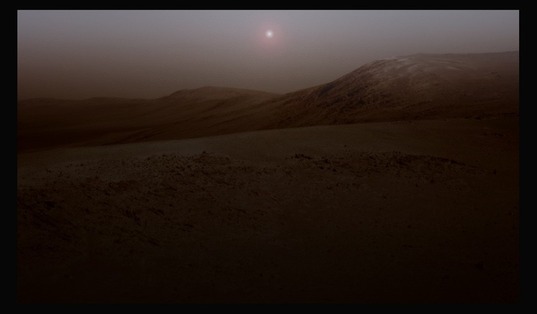
NASA / JPL-Caltech / Cornell / UA / S. Atkinson
Endeavour at twilight
This ethereal image is not real, but it shows what Opportunity's view at twilight might be from Endeavour Crater. The robot field geologist captured the raw pictures that went into this image with her panoramic camera (Pancam) and Stuart Atkinson of UMSF.com artistically processed into art. For more of Atkinson's work, visit his Road to Endeavour blogSupport our core enterprises
Your support powers our mission to explore worlds, find life, and defend Earth. You make all the difference when you make a gift. Give today!
Donate

 Explore Worlds
 Find Life
 Defend Earth


