A.J.S. Rayl • Nov 30, 2011
Mars Exploration Rovers Update:Opportunity Crunches Homestake, Scouts Locales for Winter
As NASA’s next generation, $2.5 billion rover Curiosity lifted off on an 8.5-month flight to Mars and commandeered headlines around the world last weekend, Opportunity was roving toward the end of its eighth year of exploration on the Red Planet and chalking up yet another “exciting” textbook discovery for the Mars Exploration Rover (MER) mission.
The latest MER finding emerged this month from data Opportunity collected on a striking, light-toned vein in a layer of bedrock, which it first spotted in late October and which it “crunched” apart this month. The vein, dubbed Homestake, is “different than anything we’ve ever seen with either rover,” Steve Squyres, MER principal investigator, of Cornell University, noted in last month’s MER Update.
Since then, speculation and hypotheses – from carbonates to magnetite to phyllosilicates – have been abounding in the MER milieu. For those who have been following the mission, Homestake looks, at least to the untrained eye, to be bearing sulfate, hence more evidence of past water.
All Squyres would confirm during an interview yesterday is that Homestake is "one more piece in the puzzle."
Beyond that, stay tuned. Squyres and Ray Arvidson, MER deputy principal investigator, of Washington University St. Louis, are scheduled to announce the details of the Homestake discovery at the American Geophysical Union (AGU) fall meeting in San Francisco next Wednesday, December 7. An update will be posted once the embargo is lifted.
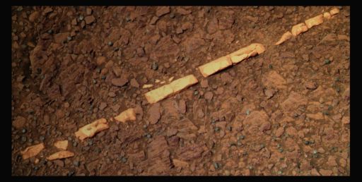 Homestake
Opportunity took this picture of Homestake, the striking vein running through bedrock, earlier this month. Stuart Atkinson, of UMSF.com, the MER poet dude and a frequent image contributor to the MER Update, processed it here in rich color. "This is different than anything we've ever seen with either rover," said MER PI Steve Squyres last month. On Dec. 7, at the American Geophysical Union fall meeting, he and Ray Arvidson will announce what Homestake is harboring.Credit: NASA / JPL-Caltech / Cornell / S. Atkinson
Meanwhile, Opportunity has roved on at Cape York, north along the rim of Endeavour Crater, on a mission to check-out two sites in which it might hunker down for this Martian winter. The MER team selected the two potential winter havens for their northerly slopes on which the solar-powered robot can park to take in as much sunlight as possible for energy production during the brutally cold season.
"There's a southern candidate for a winter haven and a northern candidate winter haven within about 20 meters of one another, and they both have slopes of 10 to 20 degrees north," said Arvidson, who is serving as the science lead for the winter campaign. "They're both good from a northerly tilt perspective, and so we will have to assess the science at both [sites] before deciding where the vehicle will spend the winter," added Squyres.
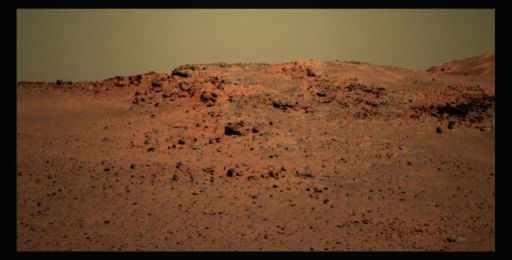
Once her work at Homestake was done, Opportunity drove to the first or southern site at Cape York North. Although the site has not yet been given a team christening, some team members took to calling Turkey Haven, since that’s where the rover settled in for the long Thanksgiving holiday.
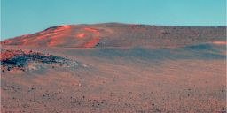 Approaching first winter haven candidate site Opportunity used her stereo panoramic camera (Pancam) to take the pictures that went into this image, which were then processed by the Pancam team. This view shows the place that team members took to calling Turkey Haven, on the left, middle of the frame. This site offers the rover a northerly slope and may be chosen as the place the rover will park for a while during this Martian winter. Credit: NASA / JPL-Caltech / Cornell University
The robot field geologist spent a good part of the long holiday there examining another Noachian Period rock the team called Transvaal, after the historical province in South Africa. "Transvaal ended up looking very similar to Chester Lake," according to both Squyres and Arvidson, a rock determined to be an impact breccia. Suffice to say, it didn't exactly bowl them over, and Opportunity roved on.
"Now the plan is to drive to the northern winter candidate site, find another rock target, finish that up, and then begin to look to settle into either the northern or the southern site for the winter," summed up Arvidson.
Turns out, Opportunity may be able to drive throughout December and not park for winter until January, according to John Callas, MER project manager at the Jet Propulsion Laboratory (JPL), where Opportunity – and her descendant Curiosity – were designed and built. "We want to maximize the science we can do, so I want the team to take advantage of the mobility we have, with the power levels we have available to us now," he said. "The engineering analysis is that we need to be above a 5-degree slope by January. That means we don't have to hunker down now, and that we could spend December doing science, just as long as we're always never more than a short step away from getting into that winter haven."
Opportunity is looking good and roving well 94th months into what was originally a 90-day mission. The robot began the month of November sporting about 300 watt-hours of power, a little less than one-third of being "fully charged," and those power levels held pretty steady throughout the month.
November was "pretty much business as usual for Opportunity," offered Nelson. "No new issues, she's driving fine."
 Simulation of Opportunity at first winter have candidate site
This simulated image, courtesy of UMSF.com member Mike Howard, creator of the Midnight Martian Browser, shows Opportunity in place at the first winter haven candidate, a place team members took to calling Turkey Haven because it's where the rover would spend Thanksgiving, the American holiday where a lot of turkey is served.Credit: NASA / JPL-Caltech / M. Howard
The rover, however, is producing less power, as expected this time of year. "We haven't had any cleaning events and the dust factor continues to deteriorate, which means the rover is getting less energy," confirmed Callas.
The sky overhead cleared measurably this month and so the Tau or measurement of opacity from dust in the atmosphere improved. But as the dust cleared from the sky, the coating of the powdery stuff on the rover's solar arrays increased to counter any potential power bump that might have ensued. That dust, after all, has to fall somewhere.
"The dust factor is about. .47 – that means only 47% of the light hitting the array is actually penetrating the dust layer," reported Bill Nelson, chief of the rover engineering team at JPL. "But our tilt right now is 10 degrees northerly which is helping a lot."
Given the nadir of the Sun actually, it means the rover is getting nearly direct Sun at Noon local Mars time, and for a solar-powered rover, well – that's basking perfection. "But winter solstice [in the southern hemisphere of Mars] isn't until the end of March, so things will continue to darken for the next several months," cautioned Callas.
Still the planning, computer modeling, and preparation of the MER team is once again paying off. There seems almost no doubt now that Opportunity will be able to work throughout much of this Martian winter, barring any unforeseen or untoward events of course. " I think that's a pretty good bet," said Squyres. "We'll see how things go, but we're doing pretty well these days."
During the next week or so, Opportunity will be checking out the science potential at the northern winter haven candidate. "This site looks more interesting to us as far as its slopes," noted Nelson, "but either one would be adequate for us."
The team members will decide together likely sometime soon, after comparing both sites in terms of their slopes and the science potential. "Where we wind up parked is going to be a combination of tilt and geology," said Arvidson.
With the spotlight on Curiosity this month, Opportunity quietly forged ahead this month, returning a significant new finding and making her team proud, something this rover has done so consistently during the last eight Earth years that she seems to have made a fine art of it.
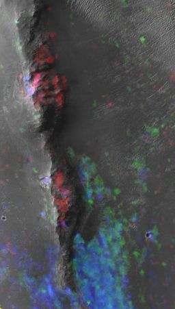 Mineral map of Endeavour's western rim
CRISM spectral maps of Endeavour's western rim show smectite (red) associated with the upraised rim rocks and hydrated sulfate minerals (blue) associated with the lower-elevation sedimentary fill. The image is aproximately 1.5 kilometers wide.Credit: NASA / JPL / UA / JHUAPL
While everyone wants the new Mars Science Laboratory mission to succeed – and many former MER-ers have shifted alliance to Curiosity – there is healthy sense of competition, and rightfully so. Beyond having to contend with another robot that is bigger, badder, and faster, Opportunity is in the race to find phyllosilicates and, with Curiosity's picture perfect launch, that race is heating up.
Ground-truthing phyllosilicates – specifically the clay minerals that have been detected from the Compact Reconnaissance Imaging Spectrometer for Mars (CRISM) onboard the Mars Reconnaissance Orbiter – is a key objective for Curiosity. Finding these clay minerals will be the hard evidence that near neutral water did flow on Mars in the past, water that was much more conducive to the formation of life than the acidic past water for which both Spirit and Opportunity found much evidence. And that is a big Martian deal. It will be a landmark discovery in planetary science.
Curiosity won't arrive until August 2012, so right now Opportunity certainly appears to have the edge, despite the fact that the Martian winter will slow this robot field geologist down through March-April of next year.
The real challenge for Opportunity though is in the harsh reality that the two most important instruments for easily and swiftly detecting the clay mineral phyllosilicates – the miniature thermal emission spectrometer (Mini-TES) and the Mössbauer spectrometer – have suffered the slings and arrows of both Mars and old age. The Mini-TES is not working at all, and the Mössbauer, with its nuclear power source depleted by many half-lives, now requires months to collect the data necessary to get a good "read" on a target's composition.
Even so, one is hard-pressed to find anyone on either mission team willing to bet against Opportunity. "I do believe we have set a very high bar for Curiosity," said Nelson.
In other MER news, John Richard “Rich” Morris who held several positions on the MER team, including that of Mission Manager, and most recently was working on Mars Science Laboratory / Curiosity, passed away on Tuesday, October 18, 2011 at his home in Altadena, California.
 Rich Morris
Credit: The Morris Family
Born November 25, 1973 in Enid, Oklahoma, Morris graduated from Memorial High School in 1992 in Edmond, OK and attended East Central University in Ada, OK. He received degrees from Pepperdine University and the University of Southern California in Natural Science and Aerospace Engineering, and was employed for the last 10 years at JPL.
His co-workers and friends remember him as a brilliant engineer and talented musician, with a great sense of humor, and a true gentleman. When he wasn't guiding the rovers, Morris enjoyed playing guitar, trumpet and singing lead for his band, Marcia! Marcia! Marcia! Rich also enjoyed traveling, playing soccer, theater at Caltech, and watching Sooner football. He was an excellent photographer, actor, musician and singer.
Morris was known for giving the best hugs ever, having great blue eyes, and a wonderful smile and will be greatly missed by many people, including the members of the MER and MSL teams, among many others at JPL. He is survived by his parents, Nancy and Joe Warren of Oklahoma City, OK; Joe and Jean Morris of Enid, OK; his brother, Robert Warren and sister-in-law Jennifer; sisters Kim Morris and Karen Morris; his grandmother, Helen Laughlin, and a number of aunts, uncles, and cousins.
Opportunity from Meridiani Planum
When November 2011 dawned at Meridiani Planum, Mars, Opportunity was en route to Homestake, the light-toned vein it spotted as Halloween was spooking the Earth, and on Sol 2763 (November 1, 2011), the robot field geologist bumped the final 3.7 meters (12 feet) to the target named for the South Dakota mine. "We moved in to get close up and personal with it," said Arvidson.
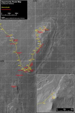 Opportunity route map
This Opportunity route map was produced by Eduardo Tesheiner, of UnmannedSpaceflight.com, and created from images taken by cameras onboard the Mars Reconnaissance Orbiter. It shows the rover's travel to its Sol 2790 (Nov. 29, 2011) and its last drive of the month. The rover officially reached the rim of Endeavour Crater on Aug. 9, 2011 and is currently scouting locations in which to seek haven during the worst of this Martian winter.Credit: Credit: NASA / JPL-Caltech / UA / MSSS / E. Tesheiner
The following sol, the rover used her microscopic imager (MI) to take a series of close-up pictures of Homestake, and then placed her alpha particle X-ray spectrometer (APXS) on the vein for an overnight integration to try and determine its composition.
Opportunity collected additional MI pictures on Sol 2765 (November 3, 2011), and then slightly adjusted the positioning of the APXS to better center the target within the sweet spot of the instrument. The next sol, she took more MI pictures of Homestake and positioned the APXS on a different part of the vein for another integration to really get a handle on what this vein is made of.
The rover wrapped up the first week of November on Sol 2769 (November 7, 2011) with a 1-meter (3-foot) bump to set up for some in-situ science on a patch of exposed bedrock.
This bedrock, which the team dubbed Deadwood, after a town near Homestake, South Dakota, is part of the same unit that contains the Homestake vein. "We wanted to know what Homestake was injected into," explained Squyres.
Opportunity began the second week of the month on Sol 2770 (November 8, 2011) with a small pirouette to position herself in front Deadwood and began a quick, but systematic inspection of the bedrock, which concluded the following sol. "The other cool thing we did before leaving [the area] to map the possible winter sites was what I call a triple crunch over Homestake," said Arvidson. "Right after finishing Deadwood, we backed over the vein, drove forward, then turned in place and left. We crunched it, removed the dust cover to the extent it existed, and exposed some bright sparkly bits."
As the scientists began reviewing the pictures and data that Opportunity had collected on Homestake and Deadwood, they also joined with the rover engineers to select two candidate sites at the northern end of Cape York for Opportunity's winter haven. Both sites feature north-facing slopes that offer the rover favorable access to the Sun during the time it hunkers down for the season.
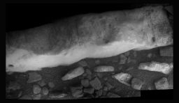
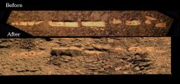 Homestake before and after
This double frame illustration shows Homestake before and after Opportunity got "up close and personal" with it. Once the rover completed her in situ investigation of the striking looking vein, she drove backward and forward over it and then turned in place to break it up. Beyond making a mess, the rover managed to reveal "bright sparkly bits," as Ray Arvidson put it.Credit: NASA / JPL-Caltech / Cornell / S. Atkinson
On Sol 2773 (November 12, 2011), Opportunity was instructed to head out to the southern winter haven candidate site, and roved more than 164-feet (50-meters) to the east/northeast toward the outcrop, said Arvidson. After a day of rest, remote sensing, and taking care of the usual routine business, the rover drove again on Sol 2775 (November 14, 2011), this time to the east, putting about 40 meters (131.23 feet) behind it, as well as dogleg tracks left by its adept maneuvering to avoid a large ripple.
The site was easily in Opportunity's view as the third week of November took hold, and on Sol 2777 (November 16, 2011), the rover cruised northeast with a drive of a little over 35 meters (about 115 feet) toward the first winter haven candidate site.
On Sol 2778 (November 17, 2011), Opportunity moved just under 12 meters (39.37 feet) to the south approaching the site, which was by then being called Turkey Haven by some of the team members since the rover would be spending Thanksgiving there. On that drive, the rover's attitude increased to 10 degrees of northerly tilt. She stayed put for a couple of sols, taking an atmospheric argon measurement with the APXS on Sol 2780 (November 19, 2011), and snapping a bunch of pictures of its surroundings, as well as taking care of all the routine things.
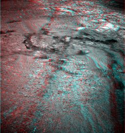 Triple crunch in 3D
After Opportunity performed a "triple crunch" on Homestake, the rover took pictures with her Pancam, and Stuart Atkinson processed them and rendered the image here in 3D. For more of Atkinson's work, please visit his blog at: http://roadtoendeavour.wordpress.com/
Credit: NASA / JPL-Caltech / Cornell / D. Bouic
Because of the coming holiday, the MER team designed and the rover implemented multi-sol plans for the last three planning days before Thanksgiving.
On Sol 2781 (November 20, 2011), Opportunity scooted about 3 meters (just under 10 feet) to be able to reach Transvaal, an interesting surface bedrock target that the team believes to be of the Noachian Period, the earliest period on Mars, when high impact cratering rates formed densely cratered terrains, and there was a high rate of valley formation and erosion. During that scoot, the rover's tilt increased to about 12 degrees as she moved up the northerly slope.
With the last week of November setting in, Opportunity made a very small turn on Sol 2783 (November 22, 2011), to position her IDD above Transvaal, and later that sol collected another atmospheric argon measurement, for the mission-long study of the argon in Mars' atmosphere.
The rover spent the rest of the Thanksgiving holiday collecting MI pictures of this new surface target, along with an APXS measurements of the same. "We parked the vehicle on a slope of about 12 degrees over Thanksgiving, and put the IDD, MI and APXS down onto Transvaal," Arvidson confirmed.
Opportunity also worked on other science assignments during the long weekend. On Sol 2784 (November 23, 2011), the rover spent quality time assessing the dust in the skies overhead with her stereo panoramic camera (Pancam), taking tau measurements, and on Sol 2785 (Thanksgiving Day) she continued an agenda of remote sensing, which included taking some super resolution pictures of the crater rim, looking at soil, and another outcrop target called Mpangeni, part of the same Turkey Haven outcrop.
The rover conducted more remote sensing and another soil study on Sol 2786 (November 25, 2011), and then on Sol 2787 (November 26, 2011) took an MI stack of pictures of Transvaal, before placing the APXS on it. The next sol, 2788 (November 27, 2011), Opportunity used her Pancam to shoot some super resolution pictures of dunes in the area.
When the data that Opportunity collected on Transvaal arrived on Earth, the scientists basically shrugged. "It looks like Chester Lake, nothing special," as Arvidson summed it up.
"We're back onto the main ridge, back into Noachian stuff, and what we're seeing here looks very, very much like what we saw at Chester Lake," added Squyres. "And we've still got a mystery on our hands. We saw this zinc at Tisdale2 [in September] and what we were unable to do at Tisdale2 was RAT the thing, because it was too rough of a surface, just was way too bumpy for the RAT to handle."
Thus, they don't know if the zinc was a coating on top of Tisdale2 or if it is part of the rock's interior composition. "We've been looking for more zinc since and we haven't found it," Squyres continued. "There was no zinc enrichment at Chester Lake and no zinc enrichment at Transvaal. What I'd like to do is find another zinc-rich rock that we can actually RAT to see if it's a coating or if it goes all the way through. So the high zinc we saw back at Tisdale remains a mystery."
Opportunity finished out November 2011 taking Pancam pictures of her tracks and the northern winter haven candidate on Sol 2789 (November 28, 2011) and driving toward the northern winter haven candidate on the following sol.
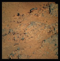 Transvaal
Opportunity took this picture of Transvaal with her Pancam last week. The rock named after the historic South African province, is a remnant of the Noachian Period and looks compositionally a lot like Chester Lake, another Noachian rock that the rover examined last month. Transvaal is in the area where the rover spent her Thanksgiving holiday, a winter haven candidate that came to unofficially be called Turkey Haven.
Credit: NASA / JPL-Caltech / Cornell / S. Atkinson
"We're driving now toward the second haven candidate which is not that far away," confirmed Callas yesterday. "There is additional outcrop at the northern winter haven candidate we want to check out," added Arvidson. "We want to go up and taste the rocks before making a decision as to where the rover will spend the winter."
Opportunity completed that jaunt yesterday, her Sol 2790 (November 29, 2011), roving 12.22 meters (40.09 feet) all told, which brought her total odometry at month's end to 34.35 kilometers (about 21.34 miles).
"It's not a big area," said Nelson of the second winter haven candidate. "It's maybe two or three rover widths wide and maybe as much as four long, but it appears to have slopes that may be as high as 18 degrees, and that's pretty juicy for us."
"Over the next few planning cycles, we'll mosey around trying to find another IDD target," said Arvidson. "We'll be able to be mobile in this vicinity all December, and that's the plan. Then, sometime in January, we'll put the vehicle in either the northern site or the southern site and begin the winter science campaign there, doing whatever we can do."
Although the Martian winter is already beginning to grip Meridiani Planum, no one on the team is committing now to exactly when Opportunity will park, or when the rover must be in a particular orientation on a north-facing slope, other than she needs to be on a 5-degree slope in January. For now she is roving on. "We just have to know we can get to where we can hunker down if we need to when the Sun gets low on the horizon," said Callas.
There is, however, still some hope that Opportunity could experience a good dust-cleaning event. "It turns out in all the wind modeling and the observations that people see of streaks, if the vehicle is exposed to winds coming from the southeast, [from which] the winds blow during the Martian winters, there's a possibility for a dust clearing," said Arvidson.
At the place currently known as Turkey Haven, "we can actually see to the southeast into the crater Endeavour, so that would be a good place in terms of maximizing the chance that we'll get some dust removal," Arvidson pointed out. "We need to evaluate possible locations like that at the northern site."
 View from the place currently known as Turkey Haven
During the long American Thanksgiving holiday, Opportunity took a lot of pictures from the small northerly slope that some team members took to calling Turkey Haven, including the series of pictures that Damien Bouic, a member of UMSF.com, processed into this lush panorama here.Credit: NASA / JPL-Caltech / Cornell / D. Bouic
Indeed, Opportunity's focus for the immediate future is on the second winter haven. "We're trying to get a better angle on it and take some additional images of the area, both to look for science targets for the winter and to get a confirming read on the slopes in the area," said Nelson.
The rover doesn't need that much of a slope to survive or even to get in some decent science research during this Martian winter. "If we got 10-degree slope, we would have power levels comparable to the last Martian winter for Opportunity," Callas informed. "It would really be desirous to have as much tilt as possible this winter, but also as much mobility as possible. In all previous Martian years, we've always had a cleaning event sometime before the winter solstice and we haven't had one yet, and we can't plan on it. This could be the year we don't get a cleaning event, in which case we'd want to get as much tilt as possible," he rationalized. "If we have the power but can't move the vehicle, because the area is too small, then we would like to find an exciting science target where we could use the Mössbauer spectrometer and do a very long integration on that site since we'd be staying put."
The other thing Opportunity may do if she's stationary for any length of time is the radio tracking experiment that Spirit was to have done earlier this year, as noted in earlier MER Updates. "With the rover immobile, the Doppler signature in the X band signal is a proxy for the rotation of the planet, and so we'd be able to measure the spin axis of Mars very precisely to see how it has changed since the Viking days," Callas said. "We'd get a very precise measurement of the precession of that pole, as well as the mutation or 'wobble' in the planet, in an attempt to better determine the size and the physical state of the core of the planet."
There's been a lot of talk about that radio science study especially in recent weeks, and JPL's Bill Folkner, a physicist, technologist, and MER science team member, has been patiently waiting the entire mission to do this work. Folkner's experiments to measure radio signals from the Mars Pathfinder lander and determine the rate of spin of Mars confirmed, for the first time, that Mars has a dense core as expected and similar work with Opportunity could add to that knowledge.
A good number of team members expect that Opportunity will be stationary for a period of time during this Martian winter if only to do some of the long-awaited radio science work. "It's a very important measurement to do that we can do, but it means being stationary and you know Opportunity loves to drive," Callas noted. "We have that constant tension between – are we going to stay put to do this measurement – or – are we going to get on the road and move?"
"If Opportunity parks with a 15-degree tilt, we should be able to do some of the radio science," Arvidson said. "It's the most energy intensive activity we could do, so it will depend on what's happening with the dust factor and with the opacity. But our intent is to go in with the radio science experiment limited by energy. It really is the most important thing to do if we can afford the energy – and having a good place where we can get a good southeasterly wind fetch."
"We will stay put for a while, for as short a time as we can and we will get as much radio science done as we can in the time that we stay put," said Squyres. "But as soon as we have enough power to boogie, we're going to boogie."
Boogie where?
“Good question,” he responded. “There are still more interesting puzzles to be solved regarding the veins. There's continuing the hunt for the phyllosilicates on the inboard side, and before long we want to head to the south. But for now we have to find a safe place to spend the winter.”
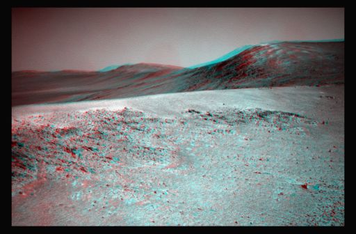 Over the ridge 3D
Opportunity took a lot of pictures this month, and Stuart Atkinson, of UMSF.com, MER poet dude, and frequent image contributor to the MER Update rendered this, the rover's view at the end November, in 3D. Get your blue-red glasses and: "Imagine striding up that slope in your spacesuit, your breath loud and rasping inside your helmet as you plough through the dust... eventually you reach the top and, huffing, shielding your eyes from the Sun with your gloved hand, look up... and down... and over... Far beneath you the floor of Endeavour is rippled with dark dust dines, and over there, on the other side, the Eastern Hills rise up into the peach-hued sky..." he notes. "Someday someone will do that." For more of Atkinson's work go to: http://roadtoendeavour.wordpress.com/Credit: NAA / JPL-Caltech / Cornell / S. Atkinson
Support our core enterprises
Your support powers our mission to explore worlds, find life, and defend Earth. You make all the difference when you make a gift. Give today!
Donate

 Explore Worlds
 Find Life
 Defend Earth


