Emily Lakdawalla • Sep 10, 2015
Pretty Pictures: Downlink of the Full New Horizons Data Set Has Begun
Since July 20, there has been a lull in the release of photos from the New Horizons flyby of Pluto. New Horizons was quite busy during that time, performing departure-phase science and relaying telemetry and non-image science data to Earth.With that phase of the mission complete, New Horizons began to return the "browse" version of its science data set on September 5, a process that will take about two months. It's called the "browse" data set because it's meant to give a relatively speedy look at nearly everything that New Horizons acquired, at a cost of some of the detail, as most of the image data will be returned compressed in one way or another.
EDIT: Originally, the plan for New Horizons data downlink was to spend two months returning a compressed version of the data set, then start over downlinking the same data uncompressed. But according to a Tweet from Alan Stern, "After seeing bad .jpg artifacts in July browse images I opted [to] go right to lossless full dataset downlink." This process is predicted to take about a year.
Processed and captioned versions of the first browse data were released today, and more will be released via the raw images website tomorrow. I should have those posted on my own version of the raw data site over the weekend. You can expect me to post processed versions of those on Monday. In the meantime, here's a first look at some of the awesome pics that came out today.
Some of the first-transmitted images are ones that we've seen already, but they were sent back with significantly less compression than the spacecraft was forced to use during the first-look data return phase in July. The less-compressed images reveal more subtle details than we could appreciate before, making Pluto even more strange and diverse than it seemed this summer. I'll share a few images with you, and describe what I see in them, and then talk a little bit about the language we use to describe new worlds.
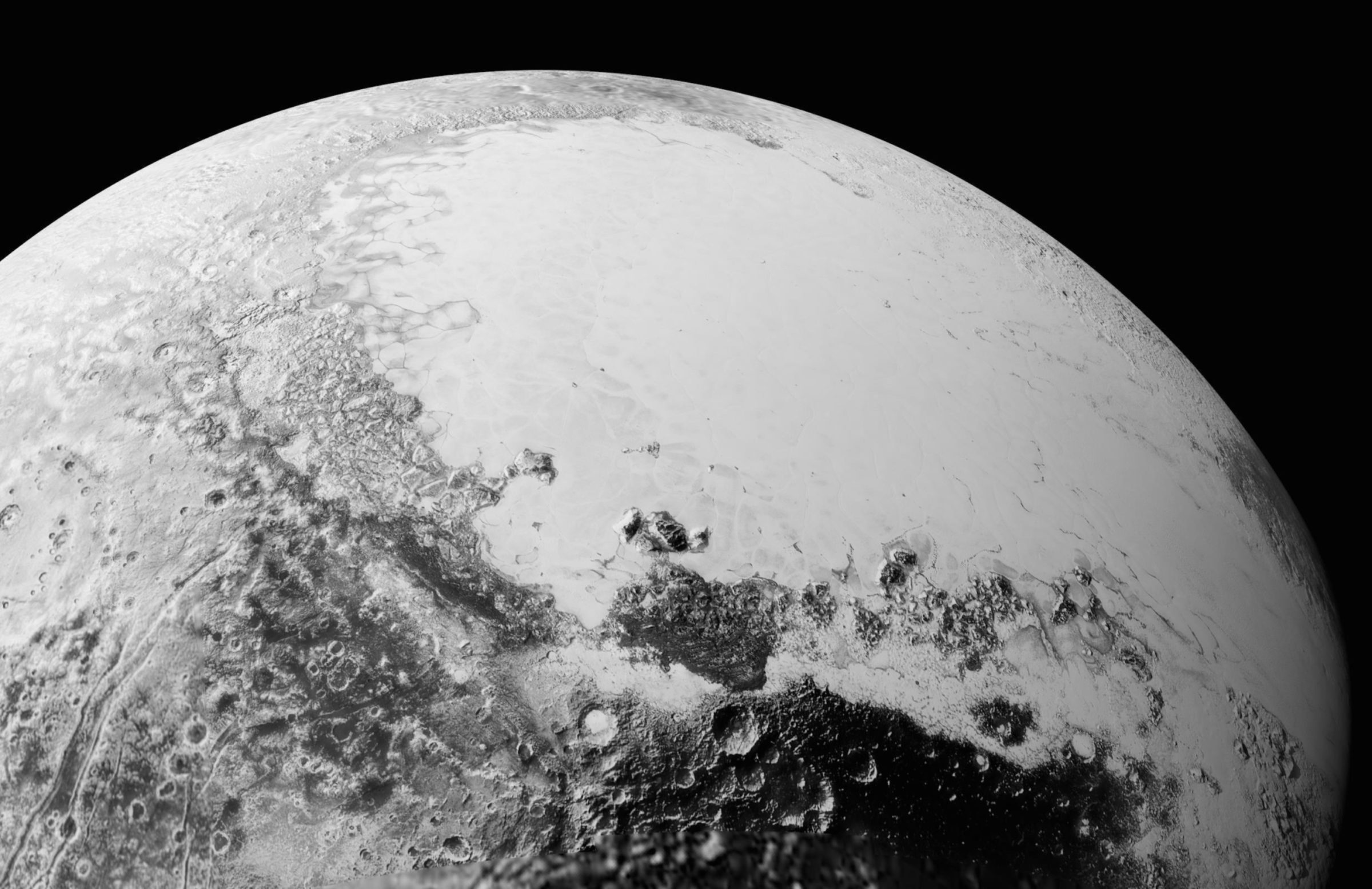
First, a quarter-spherical view for context.

This one has been rendered using frames from the high-resolution mosaic of Pluto's "heart" that we saw during the flyby, as well as more frames we haven't seen before. That mosaic has been overlaid on a slightly lower-resolution global view, but even that lower-resolution data is more detailed than anything I've seen before. There is so much variety in terrain types! What particularly grab my eye are the deep-bowled craters at the southern edge of the view, and the non-deep circular feature at the extreme left edge of the view. Both of those are places we haven't seen before at such high resolution. There are also fascinating linear features in the lower left corner. The linear features appear to have some albedo contrast along them -- parallel areas of light and dark -- but the resolution isn't sufficient for me to tell what is variation in brightness and what is variation in shadowing from topography. I also see lots of places where fainter, skinnier linear features appear to branch. That is really, really bizarre.
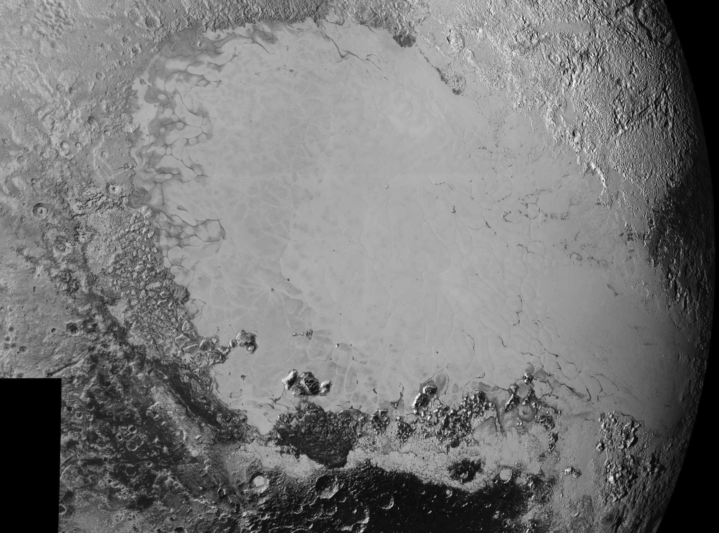
Here's another version of most of the same region on Pluto, though not including the interesting lineations at far left. This is an updated version of the "Sputnik Planum" mosaic that was available in July, encompassing more terrain.

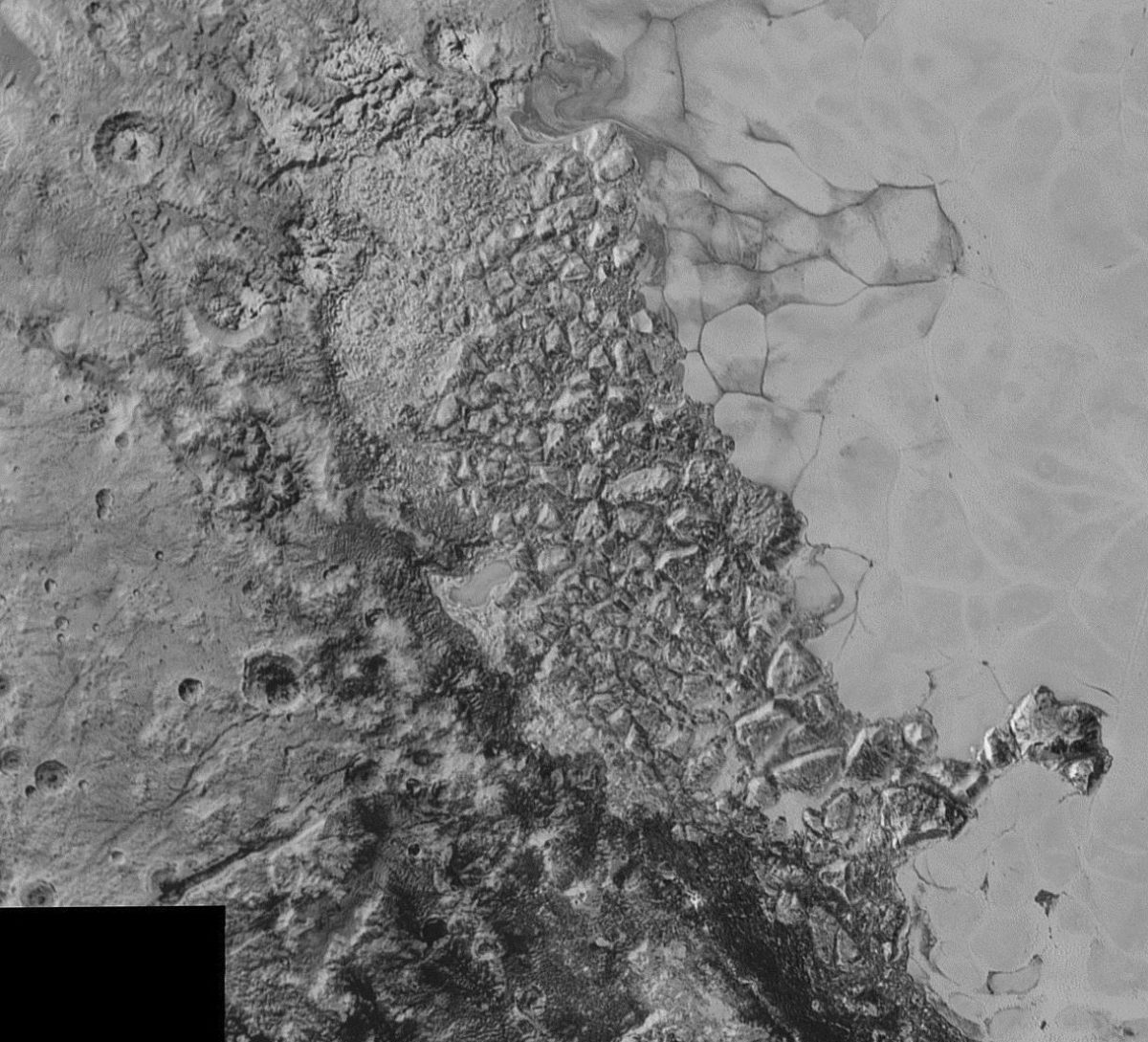
There is so much to see in this photo. There are lots of places where I see parallel lineaments, just barely visible at the resolution limit of the image. These parallel lineaments are the kind of thing that's been referred to as "chicken scratches" on other worlds. On Titan, chicken scratches turned out to be sand dunes, and that's one hypothesis under consideration for Pluto, but there are a variety of other processes that could create parallel lineations. There's also the jumble of "chaos" terrain at the upper left. Let's look at that in more detail:

We see blocks of material with steep edges and mottled terrain in between them. Both Europa and Mars have superficially similar terrain called "chaos", but Europa and Mars seem to make chaos in different ways. So I imagine that the New Horizons science team will begin with the kinds of hypotheses that work on Mars and Europa to try to understand what's happening on Pluto -- but Pluto is not Mars or Europa and may do chaos in its own unique way.
To the left of the chaos terrain, I see topographic highs whose sloping walls are dissected by linear features running in the direction that the slope is steepest. That's very unusual -- it's a kind of terrain I've only seen before on Earth, Mars, and Titan.
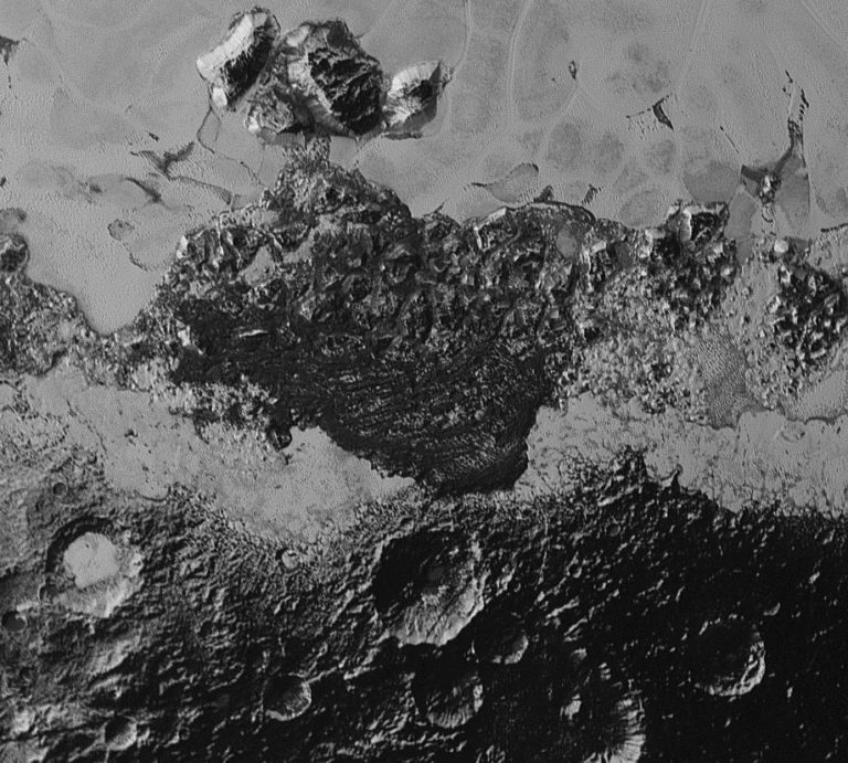
Moving farther down in the mosaic, we get to this region:

The compression artifacts in this image are bad, so you have to be cautious about interpreting the finest details. The bottom, dark area of this image has a lot of craters, many of which overlap -- I think it's the most densely cratered region of Pluto I've seen. The dense cratering could imply an old age, but it's also just a small area; you need a wider view to make sure it's not just a local spatter of impacts. Again, the walls of these craters have striations running directly downslope. In the center of the image, I get the sense that there's an east-west lineament, but it's hard to be sure. In the smoother plains areas, there are regions that I'd be tempted to call "fingerprint" terrain, with lots of short parallel lineaments.
I'm being very, very careful with my language as I describe these things. Pluto is a world we're just seeing for the first time, and which nobody understands yet. Its bewildering variety means it's likely going to be a long time before scientists can tell a coherent story that explains its appearance.
When scientists first set out to describe a new world, they're very careful to use language that describes what they see without stating an interpretation of what they see. For instance, it's very tempting for me to call the striations on those crater walls "gullies," by analogy to the gullied craters we see on Mars. I'm not going to call them that, because to call them "gullies" would be to state that I think they formed by erosion. Erosion isn't the only way you could make linear features in a crater wall. Another possibility is some tectonics-related process -- they could be fractures, like the fractures that form on some Enceladus craters. But if I called them "fractures" then I'd be discounting the hypothesis that they could have formed by erosion, or by a third different process that I haven't thought of. So instead I do neither, and call them "lineations" or "striations" or employ some visual metaphor like "chicken scratches" that doesn't imply any specific process known to occur on planetary surfaces.
Calling them "linear features" is an observation; calling them "fractures" or "gullies" is an inference. Back when I was a middle school science teacher, the difference between observations and inferences was the very first lesson I taught the room full of 9-year-olds. It's fun to look at photos and throw out hypotheses, but you're not doing science if you're jumping to conclusions, if you're not considering multiple hypotheses, or if you're not developing hypotheses that can be tested with further observation.
Have fun with these images. Explore. Keep an open mind. Stay tuned to the raw images website for new images to be released tomorrow (Friday, the 11th), and enjoy interpreting them over the weekend!
Support our core enterprises
Your support powers our mission to explore worlds, find life, and defend Earth. You make all the difference when you make a gift. Give today!
Donate

 Explore Worlds
 Find Life
 Defend Earth

