Emily Lakdawalla • Jul 20, 2015
DSCOVR mission releases first EPIC global view of Earth, more to come in September
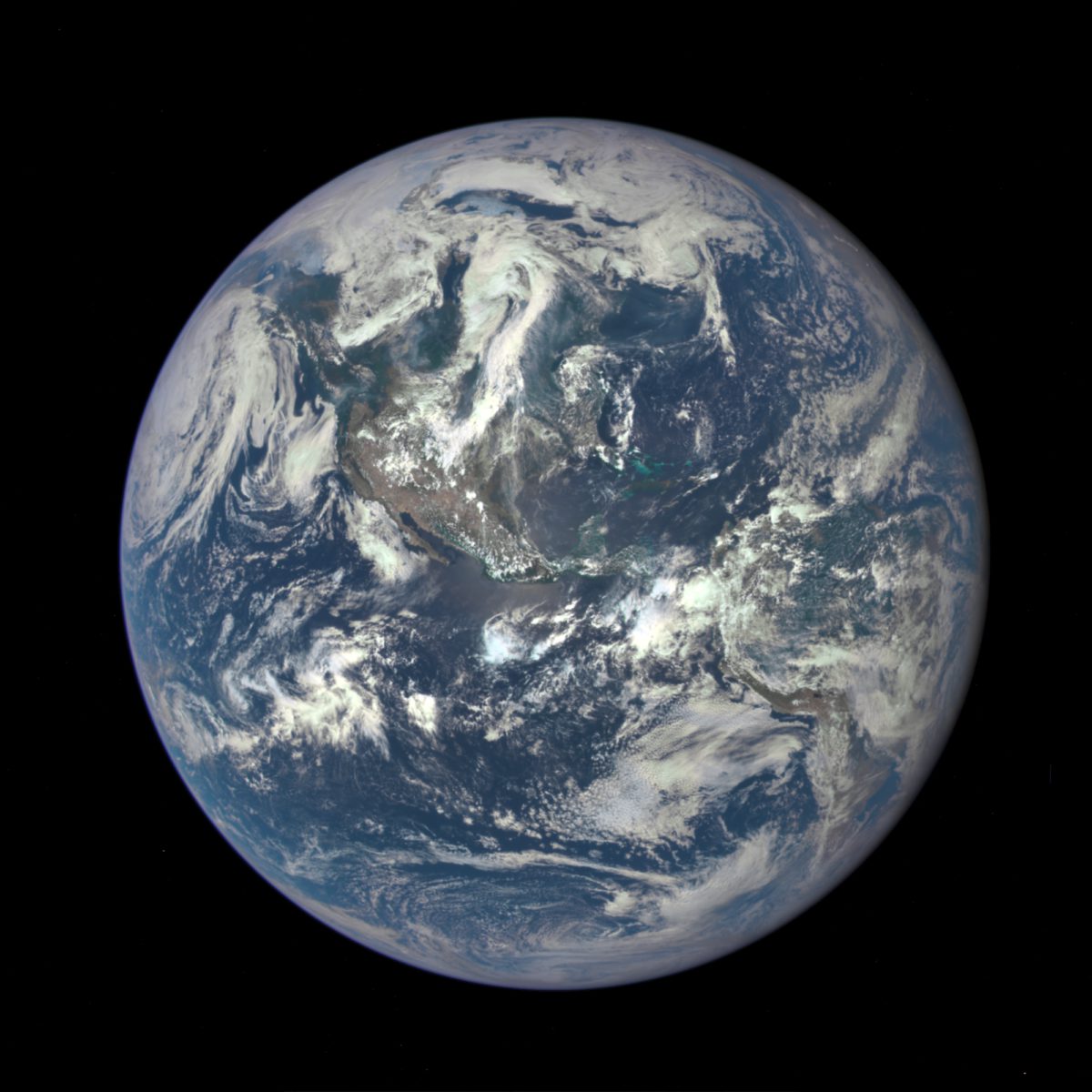
Five months after its launch, the Deep Space Climate Observatory (DSCOVR) mission has successfully journeyed to the region of space where Sun and Earth gravitational attraction offset each other. From the vantage point of L1, DSCOVR's EPIC camera has captured its first full-globe view of Earth, and it's well, epic.

There's something very moving about this photo -- its color is more muted than a lot of previous NASA "blue marble" pictures. From its point of view at L1, DSCOVR will always see a fully-lit Earth, rotating in place as the days pass, and pitching up and down with the shifting of seasons. I can't wait for more like this, of course, so I fired off a couple of emails asking for more details about how it was taken and what the plan for future data release is.
According to the release accompanying the photo, "Once the instrument begins regular data acquisition, EPIC will provide a daily series of Earth images allowing for the first time study of daily variations over the entire globe. These images, available 12 to 36 hours after they are acquired, will be posted to a dedicated web page by September 2015." NASA spokesman Stephen Cole further explained to me that the goal is to have this website up by September 1, but the actual date depends on when they get the processing pipeline ready. Images will be released once per day, and the daily release will include images between 12 and 36 hours old. The posted images will be derived color products.
The images are being taken with the Earth Polychromatic Imaging Camera (EPIC), which has a detector 2048 by 2048 pixels square. Here is a fact sheet about EPIC(PDF). EPIC has a monochromatic detector and a filter wheel with 10 very narrowband filters from ultraviolet to near-infrared wavelengths, 317 to 779 nanometers. For more information about the image released today, Cole put me in touch with DSCOVR project scientist Adam Szabo.
Szabo told me that EPIC takes images once every 1.8 hours, continuously. For this first image, red (680±0.2 nm), green (551±1 nm), and blue (443±1 nm) were returned at their full 2048-pixel-square resolution. But once EPIC starts regular imaging, data volume constraints will prevent all of these from being returned at full resolution. They will send back the blue-channel image at 2048 square, and downsample the red and green images to 1024 by 1024 before downlinking them.
Because the filters are so narrowband, a straight combination of red, green, and blue filter images wouldn't make a photo with as much verisimilitude as the one released today. I asked Szabo about that, and he told me:
Standard RGB jpeg images are encoded as three numbers, one for red, one for green and one for blue. We have three numbers on DSCOVR. The question is how to scale the three relative to each other. We have adjusted the exposure times to make sure that we are neither saturated nor lost in low signal to noise values. Then we followed the human eye color response spectrum. The human eye is much more sensitive to red and green than blue colors. But the EPIC instrument is equally sensitive to all of the filter settings. So, before combining the three filtered images, we have reduced the contribution of blue and slightly changed red. This is our best guess as how a human observer would see the Earth from L1.
The popular MODIS Earth images are enhanced in color to bring out surface features. Also, they have removed the effect of light scattered by atmospheric molecules. We will do the same for the regular processing and distribute both the human eye response coloring and the enhanced images.
The first light images are all human eye response colors.
I can't wait for this new data set to begin to build before our eyes. It is going to be a spectacular perspective on our beautiful home planet. Congratulations to the DSCOVR team on a wonderful first-light photo.
One last thing I thought I'd mention about it is that you might have noticed that North America looks smaller than it does in the most familiar "blue marble" picture previously released by NASA. Here's that one:

The difference between the two is one of distance. DSCOVR, located 1.6 million kilometers from Earth, has a similar perspective as though it were sitting at infinity; the effective map projection is an orthographic one. MODIS, orbiting only 700 kilometers above Earth, sees much less of the globe at a time. The Blue Marble image is a vertical perspective projection at some higher altitude than 700 kilometers, though I don't know what the altitude of projection is. As a result of its closer viewpoint, points near the center of the globe are much closer to the viewer than points at the globe's edge, so features near the center bulge -- it's the same effect that tends to make your nose look big when you take a selfie. I like the new perspective better!
Support our core enterprises
Your support powers our mission to explore worlds, find life, and defend Earth. You make all the difference when you make a gift. Give today!
Donate

 Explore Worlds
 Find Life
 Defend Earth

