A.J.S. Rayl • Jul 03, 2014
Mars Exploration Rovers Update: Opportunity Nears End of Murray Ridge, Pillinger Point Christened
Sols 3680-3709
Opportunity got off to a bumpy start in June, but the Mars Exploration Rover (MER) mission pressed on, continuing the exploration of Murray Ridge at the western rim of Endeavour Crater. And, by month's end, as the MER team was honoring a colleague from across the Pond on Earth, the robot field geologist was driving to another fine finish at an outcrop that may reveal more about the watery, life nourishing environment that was once here long, long ago.

Mars Exploration Rover
NASA / JPL-Caltech / Maas Digital
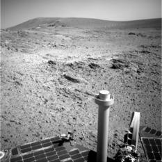
Since the beginning of May, Opportunity has been making its way through the latest clayground, a "shoestring" area along Murray Ridge that extends for some 240 meters (about 800 feet). Orbital data suggest there are montmorillonites here, aluminum hydrated minerals that belong to a class of clays known as smectites.
Given that montmorillonite forms when basalt is altered under wet and slightly acidic conditions, this clay is a sign that water once flowed through these parts, perhaps even pooled here and there in ancient times. Opportunity is looking for anything that will add new insights about the geological context for different smectites here that could boost our understanding about diversity and changes in ancient wet environments on Mars.
"We're working our way south along this ridge tasting things as we go," said Steve Squyres, MER principal investigator of Cornell University. "We're driving, sort of hugging right along the peak of the ridge, because that's where a lot of the outcrop is," added Ashley Stroupe, one of the rover planners (RPs) at JPL.
Spirit and Opportunity both found evidence supporting the long-held theory that Mars was once warmer and wetter than it is today and in some places habitable by emerging lifeforms. Then last year, Opportunity uncovered evidence for iron-bearing smectites called nontronites, as well as for montmorillonites, in rocks exposed at Cape York, yielding solid evidence for an ancient environment with near neutral water that would have been habitable for microbes if any had emerged on Mars billions of years ago.
Now the robot field geologist is ground-truthing the detection made by the Compact Reconnaissance Imaging Spectrometer for Mars (CRISM) onboard the Mars Reconnaissance Orbiter (MRO), which found a spectrum with the signature of aluminum bound to oxygen and hydrogen, regarded as a marker for montmorillonite. But the montmorillonites have been frustratingly elusive.
"It's a very subtle signature detected by CRISM," said Ray Arvidson, MER deputy prcinciapl investigator, of Washington University St. Louis (WUSTL), who is also a co-investigator on CRISM. "I'm thinking now, it's everywhere. I think the whole matrix is slightly altered."
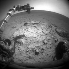
Time and more data will tell. MER is a science-driven mission and as June headed for July, Opportunity stopped to check out distinctive sheet-like exposures jutting from an intriguing Martian outcrop called Huntingburg on the breccia-laden Murray Ridge to see if they might add anything new to the water story at Endeavour Crater.
"We will be for another week or two," said Arvidson, who took oversaw the science operations for much of the month while Squyres was in the microgravity environment of Pavilion Lake in Canada doing fieldwork.
The dust storms of the Martian spring are still on the horizon and Opportunity still remains uncannily clean after her winter blow off with the highest power levels it's had since its first winter on Mars. "Considering the fact that she was supposed to last only 90 sols, she's doing extremely well," said Paolo Bellutta, MER RP, of JPL. "The power? The power is amazing. We have – oh like 750 watt-hours per sol." [That is about ¾ of Opportunity's capability.] "It is amazing after 10 years."
Despite Opportunity's almost boundless energy, no team knows better than MER that exploring Mars comes with constant challenges, especially for a veteran rover.
When June dawned at Endeavour Crater, the rover was in safe mode. Opportunity had experienced a warm reset on the second sol of a 'touch and go' on Sol 3680 (May 31, 2014), triggered, the MER engineers believe, by an error writing to its flash memory. That is to say, these warm resets were similar to warm resets that occurred in the past when the rover got an error after writing to a specific area of its flash (non-volatile) memory.
A touch and go is where the rover uses the robotic arm on the first sol of a multi-sol plan (the touch) and then drives on the next sol (the go). This time, the touch was successful and the rover collected a Microscopic Imager (MI) mosaic of the surface target, followed by an Alpha Particle X-ray Spectrometer (APXS) measurement overnight. But the drive on the next sol never occurred because of the reset.

NASA / JPL-Caltech / Cornell / Arizona State University / J. Sorenson
Pillinger Point
In a NASA-JPL press release June 24, 2014, MER's international science team announced that it has christened the rocky ridge pictured here, Pillinger Point, in honor of Colin Pillinger (1943-2014). Pillinger was the British principal investigator for the Beagle 2 lander that attempted to set down on Mars just days before Spirit's breathtaking, bounce-down landing. Opportunity gazed down into the bowl of Endeavour Crater to take this dramatic panorama of the site during her Sols 3663 to 3668 (May 14 to 19, 2014). The vista spans from north-northwest, at the left, to south-southwest, at the right. The eastern rim of the crater is on the distant horizon. "I like to think Colin would have liked this view," said Steve Squyres, MER principal investigator, who called Pillinger a friend. James Sorenson processed the pictures in this stunning image.The rover ops team restored Opportunity to normal sequence operation on Sol 3682 (June 2, 2014) and the robot, with 39.44 kilometers (24.51 miles) on her odometer, prepared to rove on. Producing more than 725 watt-hours of power under hazy skies, Tau registering 0.682, the rover's dust factor was still hanging in at a high of 0.908. Then, another warm reset occurred on Sol 3683 (June 4, 2014). This time, the team was ready and waiting, and successfully restored the robot to nominal operations the following sol.
Finally, Opportunity put her pedal to the metal, driving 19 meters (more than 62 feet) south along the ridgeline of the crater rim. For Sols 3686 to 3688 (June 6 to 8, 2014) weekend, the plan was for the rover to conduct another 'touch 'n go,' using her robotic arm on the first sol, then driving away on the second sol as usual. Again, the robot experienced a warm reset, presumably induced by a write error in flash memory.
While she was in otherwise good health, Opportunity was left without a master sequence running so it lost those three worksols. The ops team restored the rover to normal sequence control on Sol 3689 (June 10, 2014), and Opportunity completed a 21-meter (69-foot) drive.
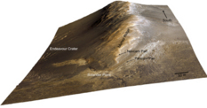
Opportunity's truly excellent ridge trip
This is a perspective view of Murray Ridge, a rim segment of the 22-kilometer (14-mile) wide Endeavour Crater, showing the topography where Opportunity has been roving in 2014. The locations where the robot field geologist acquired previous Pancam and Navcam image mosaics of the ridge are marked, though Pillinger Point is not. The view, generated from HiRISE image data and a digital topographic map generated from stereo HiRISE coverage, is shown with a 3x vertical scale exaggeration. For the area shown on this view, the ridge at its highest point rises approximately 20 meters (66 feet) relative to the plains to the west. HiRISE is a camera onboard the Mars Reconnaissance Orbiter.NASA / JPL-Caltech / UA
The warm resets in June have "similar behavior and similar symptoms" as those in the past, said John Callas, and are not life-threatening for the rover. "We recovered the vehicle after each one and proceeded on," he said. "Although we did have an amnesia event on 3693 (June 14, 2014), we have not had any warm resets or any other such issue since Sol 3686 (June 7, 2014). We had 3 resets very close together and now it's quiet."
Since Opportunity has experienced both warm resets and amnesia events before, as reported in past MER Updates, "they weren't really unexpected," said Stroupe. "The concern right now is that we are occasionally losing plans because of them. But it's not a huge concern because we think we know how to work with it and how to proceed. We're all thinking along the same lines as we have been."
The theory is that these flash memory glitches are episodic – "and that they will happen in waves," Callas said. "We think we have strong evidence that we have bad sectors in one of the flash memory chips and the algorithms that control the writing of flash memory load level don't always write in the same spot. As it spreads the data throughout the flash memory it hits this bumpy part and – bing-bing-bing – you get a bunch of resets. But as the load level moves away from that sector, then the re-sets go away," he explained. "Once it comes around again – bing-bing-bing. We've had two episodes separated by about a year where we had a bunch of re-sets in close proximity and then nothing. Now we have only had a few data points to support that and with only a few data points, you could fit almost any curve. But that's the theory."
There is a fix. Both memory issues probably can be fixed by re-formatting, but the problem has to get worse. "The problems have to be persistent and they may not be. They may recur frequently but they have to be persistent so the algorithm catches them," said Callas. "There is still a little bit of work to do to find out exactly where those bad sectors and how targeted we can be in shutting off the spots on the disc we don't want to use, because we don't want to lose a lot of disc space," added Stroupe.
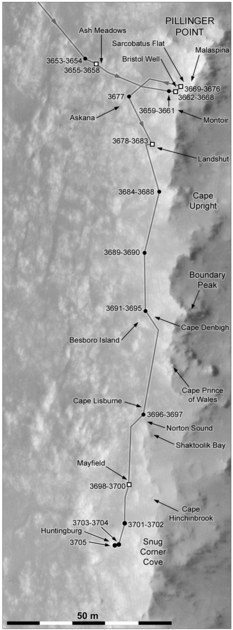
Opportunity's recent rovings
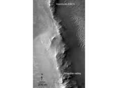
Phil Stooke has been charting Opportunity's route around Meridiani Planum for his book, the second volume of the International Atlas of Mars Exploration. In this image, he traced the rover's recent rovings, since just before it arrived at Pillinger Point to her approximate location at Huntingburg, over a base map created from imagery from the HiRISE camera onboard the Mars Reconnaissance Orbiter. North is at the top of the image, south to the bottom.Phil Stooke, University of Western Ontario / ASU
Also, the team doesn't take reformatting lightly. "There are data products in flash memory that we use that we need to have in there, so if we re-format then we have to put it all back in," said Callas. "It's a lot like re-formatting your hard drive: you have to load your operating system and software back on there before you start your computer up again."
The MER team is of course "always vigilant" about any glitch or rover problem and is renowned for its workarounds. Since the rover has energy to spare, the team is making use of the fact that every uplink is also a direct-to-Earth downlink and has been checking the rover's telemetry in "real-time." If the rover has another warm re-boot and is in otherwise good health, the team is now prepared to reset Opportunity right away as it sends up the rover's command and data bundles. "We can effectively minimize the impact, continue operations, and deal with it," said Callas. "Even if it happens frequently, we won't lose any more precious days."
"The warm reboots are an annoyance but nothing more. We can recover from them fairly quickly now, so we're just chuggin' along," summed up Squyres.
Although the sky remained storm free over Opportunity's site in Meridiani Planum, the Martian spring was in the air in June, if only briefly. "Dust-raising activity was observed off of the residual north polar cap edge, north of Tempe, and in northern Acidalia," and "local dust storms occurred across the southern mid-latitudes," in Aonia, Sirenum, Solis, and Noachis, according to the MARCI Mars Weather Report produced at Malin Space Science Systems (MSSS). MARCI, which is the Mars Color Imager camera onboard MRO, acquires a global view of the Red Planet and its weather patterns every day.
The mild weather report notwithstanding, the Tau or atmospheric opacity at Endeavour Crater rose to 0.868 during the second week of June and Opportunity's power production dropped to 660 watt-hours despite a still remarkably high dust factor of 0.924. "We're getting into that time of year where these things happen," said Callas. The dust storms observed, though far away from Opportunity, apparently "elevated dust into the atmosphere and that's what we saw over our site."
Opportunity spent 3690 (June 11, 2014) conducting remote sensing and taking care of routine tasks. On the following sol, the robot field geologist headed south for 20 meters (65.61 feet), then spent the next four sols conducting remote sensing, including taking a lot of pictures with her navigation camera and stereo panoramic camera (Pancam).
The rover revved up again on her Sold 3696 (June 17, 2014) and put another 35 meters (114.82 feet) on her rocker bogie, continuing the exploration of the montmorillonite site along Murray Ridge. With ample energy, Opportunity has been able to conduct some late-night activities. On Sol 3697 (June 18, 2014), the rover collected an atmospheric argon measurement with her APXS, and took advantage of a Phobos moon imaging opportunity.
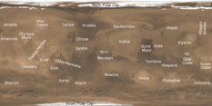
Mars weather reference map
This map shows Martian place names commonly mentioned in the Mars Color Imager or MARCI Mars Weather Report published weekly by Malin Space Science Systems (MSSS). The California company built and operates (MARCI) and Context Camera (CTX), both of which are onboard MRO.NASA / JPL-Caltech / MSSS
Opportunity drove southward again for 25 meters (82.02 feet) on her Sol 3698 (June 19, 2014) and then attempted to take more pictures of Phobos that night. The following sol, the rover conducted routine tasks, snapped some more pictures, and used her APXS to take another argon measurement that evening for a mission long study of Mars' atmosphere.
The robot field geologist conducted a 2-sol 'touch 'n go' on Sols 3700-3701, taking the pictures for an MI mosaic and subsequently analyzing the APXS measurement on a surface target at an outcrop called Mayfield on the first sol and following it with a 13.5-meter (42-foot) drive to the south on the second sol.
On Sol 3703 (June 24, 2014), Opportunity began an approach to a surface target with a 31 feet (9.4-meter) move. Also, the project continues with the spacecraft clock correction, moving the clock about 3 seconds back each sol, as reported in last month's MER Update.
Meanwhile, down on Earth, the scuttlebutt from last month was revealed to be true as the vista point with a captivating view at the northern end of the montmorillonite site that Opportunity visited and imaged in panoramic glory in May was officially christened Pillinger Point on June 24th. "We have now made Pillinger Point official," said Squyres, following the issuance of the NASA-JPL press release.
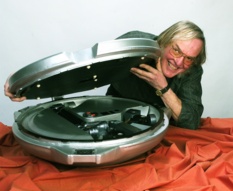
Colin Pillinger and his Beagle 2
Colin Pillinger, a professor at the Open University in England and the scientist who championed the Beagle 2 lander, died on May 7, 2014, after suffering a brain hemorrhage. He is pictured here with a model of the Beagle 2, which disappeared to an unknown fate in December 2003. "His loss is affecting us all," said Steve Squyres, MER principal investigator.Beagle 2 / Open University / ESA
It was named in honor of Colin Pillinger, the British planetary scientist and professor who championed the U.K.'s Mars lander Beagle 2 in 2003 and was awarded the Commander of the British Empire medal by the Queen for his efforts. Pillinger passed away on May 7, 2014 in Cambridge England at the age of 70.
During his Beagle 2 years, Pillinger, who taught planetary science at the Open University in England and had studied Martian meteorites, captured the hearts and scientific minds of his countrymen and women, as well as many Mars-exploring colleagues in the U.S.
"Because we were going to Mars at the same time, Colin and I were sort of thrust into the limelight together and, at times, the media would present it as a kind of a competition between the two missions," remembered Squyres. "Behind the scenes though, Colin and I became friends. I had enormous respect for Colin and what he was trying to do with Beagle and we became very strong supporters of each other's missions. I was really rooting for Beagle 2, as he was rooting for Spirit and Opportunity."
At home, on the other side of the Pond, Pillinger had done everything possible to engage the people of the UK and secure their support of his ambitious venture to Mars, and somehow he succeeded in getting Beagle 2 built. "Professor Colin Pillinger was at the heart of it – the heart and soul of Beagle 2," reflected Stuart Atkinson, author, planetary enthusiast, and MER poet, who resides in England's North Country. "With his trademark bushy mutton chop sideburns and broad West Country accent, Pillinger looked and sounded nothing like a traditional scientist, so he was often portrayed in the British press as a classic 'eccentric boffin,' but his towering intellect, passion for science and exploration, and sheer British bulldog stubbornness turned Beagle from a dream into a reality," he said.
The small, clam-shaped lander that hitched a ride on the European Space Agency's Mars Express was produced on a budget of $120 million, $40 million of which came from the British government, the rest from private interests. When Mars Express dispatched the Beagle 2 onto its final trajectory, it was to land on December 25, 2003. But the Beagle 2 was never heard from again.
"The loss of Beagle 2 was a crushing blow for British space scientists and enthusiasts alike, and all these years later it's still an open wound that refuses to heal," said Atkinson. "To this day, everyone who followed the mission of the 'plucky little Mars probe' lets out a sigh of despair, shakes their head, and wonders how history would have been different if Beagle had succeeded."

The last picture of Beagle 2
The European Space Agency's Mars Express dispatched Beagle 2 in December 2003. It was slated to land and phone home on December 25, 2003. But the Beagle 2 was silent. While there are several theories as to what happened to the lander, no one knows for sure what happened.Beagle 2 / ESA
"Colin's death is a terrible loss," said Squyres. "If you ask what is Beagle 2's legacy, what is Colin's, I think it's substantial – and I think it's largely the young people who were inspired by what Colin was trying to do with Beagle 2 and are going to try and follow in his footsteps and go into careers in science and engineering and technology and go into exploration," he said.
"It was impossible to not feel inspired by him as he almost single-handedly got Beagle built and sent to Mars, doing whatever he could and anything he had to do to get it there, and I remember seeing his huge, confident grin shining out of my TV countless times as the probe approached Barsoom," Atkinson recalled. "Then landing day, and that awful, soul-crushing silence from Mars. Colin was on TV again, every news program, from dawn until dusk, and as every communications opportunity came, and went, and Beagle remained silent, not offering even a plaintive 'help me' yap from across that timeless gulf of space, the cameras zoomed in on his face and showed that grin shrink and fade. But with the world watching, and waiting he never lost his cool, never showed the turmoil he must have been feeling inside, and his dignity shone like a beacon," he said.
"I remember very well the night we landed with Spirit – being in my office at JPL a couple of hours after the landing, and getting a very gracious, congratulatory phone call from Colin," Squyres said. "He was right in the middle of trying to regain contact with Beagle 2 at that moment, yet he took out the time and made the effort to give me a call. I thought that was a really gracious, really classy thing to do. He was quite a guy."
"When eventually all hope of contacting Beagle was lost, Pillinger kept that dignity, even when the criticism started flying and the knives came out for him," Atkinson said. "With his dream dashed, he insisted that the mission would continue, using the lessons learned, and hoped another Beagle would fly to Mars. Of course, none ever did, and I imagine that until he died the Professor spent many long, dark hours staring up at Mars shining in the sky wondering what had happened to his creation. But whatever happened to Beagle – if an EDL failure destroyed it, scattering it across the surface in a million tinkling, twinkling pieces, or if it actually landed successfully and a simple, stupid, cruel something left it unable to communicate with Earth – the fact that it got built at all was an incredible thing, and Colin Pillinger deserves to have this Martian feature named after him."
"Colin was a force of nature," summed up Squyres. It's a comment that would have anyone who knew Pillinger nodding in agreement. "He had an enthusiasm and a passion for Mars exploration that was just unparalleled and he inspired a lot of people. He inspired me. He's irreplaceable and he's going to be very much missed. I'm proud to have known him, and I'm really, really glad we were able to find such a beautiful spot on Mars to name after him. I like to think Colin would have liked this view."
"It's not hard to imagine him sitting on the cold, time-smoothed rocks of Pillinger Point, watching the Sun go down behind the mountains marking the rim of Endeavour Crater, and grinning that huge grin as he drinks in the beauty of it all ... and wondering if, somewhere beyond those hills, a faithful Beagle is waiting for him," agreed Atkinson.

NASA / JPL-Caltech / Cornell / Arizona State University
A colorful view of Pillinger Point
"The Pillinger Pan is an interesting tutorial in lighting, because the middle of the pan is with the light right behind us, zero phase angle, you don't have many shadows so you're looking kind of intrinsically into the rock," said Ray Arvidson, MER deputy principal investigator. "If you look off the left and to the right, the Sun is not directly behind you so you see more of the textures – and if you look to the right you can see a set of layers that could have tilted back to the west and have sharp edges, steep edges on the uphill side." The panorama is processed here by the Pancam team in false color."The panorama is spectacular," said Callas. "It's really one of our best, a great vantage point and it demonstrates that even after 10 years we can still take great pictures."
Beyond the honor and the beauty in the landscape in the spirit of Ansel Adams, Pillinger Point Pan may be scientifically telling, offering perhaps clues to the location of the montmorillonite clay minerals for which Oppy has been searching.
"Pillinger Point in this pan is just beautifully illuminated," said Arvidson. "I think the idea that the whole matrix is slightly altered shows up nicely here, because the ridge is tilted toward the Sun and you can see into those rocks, with the Sun directly behind you, and along with what CRISM is seeing [also with the Sun more or less at the back of the instrument] you're looking deeply into the rock. I think what it's telling us – most likely – is that large parts of the Shoemaker Formation breccia has been slightly altered to montmorillonite, but we just can't see it because of the soil cover and the lighting," he said.
While the breccia, most likely hurled up from whatever created Endeavour Crater, has big clasts, but "a very fine-grained matrix that started out as glass, and very fine-grained material broken up mechanically," Arvidson explained. "The glass, because of the small particle size and the kind of amorphous nature of it, with a little bit of water is going to lead to its alteration into a little bit of clay without changing the chemistry dramatically. I think that's what was happening," he said. "It's the same chemistry, different mineralogy, and not a lot of montmorillonite, just enough to give us that signature."
So the water that was once in this area on Murray Ridge literally changed part of the rock into clay? "This is Shoemaker Formation, the breccia sitting on top of Matijevic Formation, so it's not surprising that the matrix of the Shoemaker is altered everywhere because this impact occurred back when Mars had channels with water and lakes," said Arvidson. "It would have impacted into a pretty moist crust and a moist, hot crust afterward. Therefore, considering warm conditions and a little bit of moisture, a little bit of alteration seems consistent." As always, time and more data will tell.
In the meantime, word backstage is that the MER team is nearing consensus with the Russians regarding the revised final distance of Lunokhod 2, the Russian Moon rover that has held the rover distance record on another planet since 1973, and Opportunity's forthcoming claim to the crown.
Brad Jolliff, a MER ops team member and Lunar Reconnaissance Orbiter (LROC) science team member, of WUSTL, is still conversing with the Russians about the Lunokhod 2 odometry, which has been reviewed and revised since the Moon orbiter returned new imagery where the rover's tracks can be seen. "Our colleague Irina Karachevtseva at Moscow State University is an expert on the Lunokhod 2 traverse and we are working together to be sure we agree on the Lunokhod 2 traverse mapped distance," Jolliff confirmed by email.
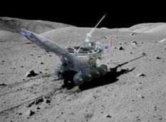
Lunokhod 2
This simulated image shows Lunokhod 2 as it might have roved on the Moon. The second of two unmanned Soviet rovers sent to the Moon in 1973, Lunokhod 2 still holds the international record for distance traveled on another planetary body. For decades, it was stated that this "Moon Walker" traveled 37 kilometers (23 miles) on the surface. But in June 2013, new imagery from the Lunar Reconnaissance Orbiter (LROC) had both Russians and Americans revisiting that number. The two teams are still "sharpening their pencils" to make sure all measurements are "accurate and robust," said MER Project Manager John Callas.Russian Academy of Sciences
To date, the teams have agreed Lunokhod 2 traveled 39 kilometers +/- about 100 meters. That distance, however, has not yet published and is still considered preliminary as the analysis and tracking continues.
At the same time, Tim Parker, a member of the MER Athena science team and the mission's geology team group lead, and Fred Calef, a geospatial information scientist at Caltech-JPL, are currently joining forces with Mark Mamoine, a navigation and machine vision researcher at JPL who designed and developed the autonomous vision and navigation software that lets Opportunity and Curiosity drive themselves safely, to get the best possible mapped distance estimate for Opportunity so the Russians and the Americans can effectively make for an "apples to apples" comparison with the measure of the traverse distance of Lunokhod 2.
"They are sharpening their pencils on a few points to make sure our analysis is robust," said Callas.
"The problem is that there are different ways of computing odometry and we want to be absolutely certain that we have beaten the Lunokhod 2 record once we claim to have done it," Squyres reminded. "We're not there yet."
"This comparison is a little tricky because we are making measurements using different software and different spacecraft observations – HiRISE on Mars, LRO on Moon – as the basis for comparison," Jolliff elaborated.
Once Opportunity has traversed a mapped distance that exceeds the Lunokhod 2 traverse by an amount well beyond the uncertainties associated with either traverse measurement, there, no doubt, will be an announcement. "We want to make sure our analysis is comparable and so we're doing that," said Callas.
All that noted, as of June 30, 2014, Opportunity has 39.59 kilometers (24.60 miles) on her odometer. Which technically would seem to mean MER has already become the most traveled rover on another planet, silently and without any fanfare. Nevertheless, Squyres was adamant. "When we are confident and the Russians we're working with concur that we have exceeded the record, we will announce that we have exceeded the record but that hasn't happened yet," he said.
For many on the MER team, the celebration won't have that "spontaneous intensity" to it, as Callas put it. "It's been so long coming and with so much discussion, that it's a little anti-climactic in a way," agreed Stroupe. "But obviously it will be wonderful when we finally get it official and we are definitely looking forward to that."
As much as it will be a celebration of MER and Opportunity's achievement, it will also be a time to reflect on what the Russians succeeded in doing more than 40 years ago, as Squyres has previously noted.

Lunokhod 2 tracks on the Moon
On January 18, 1973, with a full battery charge Lunokhod 2 circumnavigated and imaged its faithful Soviet Luna 21 lander, and then began its record-setting journey across the lunar landscape. Controllers in Simferopol, Crimea, operated the eightwheeled rover for five Earth months mainly by using a mast-mounted TV camera and ‘joystick’ controls. It survived four bitterly cold lunar nights as low as -240 °F, and racked up a newly revised estimated 39+ km (~24.4 miles) of traverse distance, but researchers are still analyzing the tracks. This image, which the LROC team recently posted on its site, shows a cross-like pattern of Lunokhod 2's tracks as it explored a small crater. Whatever Lunokhod 2's final distance, it is the only rover distance record that Opportunity has to best. For more LROC images: http://lroc.sese.asu.edu/posts/774NASA / GSFC / ASU
"It will be a great opportunity for us to celebrate the accomplishments of both space vehicles, one operating today on Mars and one that operated on the Moon over 40 years ago," Jolliff said. "It is a time for us to share a little kinship with our Russian colleagues who also share with us the excitement of planetary surface exploration."
As the MER team looks forward to the geological treasure awaiting Opportunity 2 kilometers to the south, NASA will soon be considering the mission's proposal seeking a ninth extension to keep the veteran rover roving. A final report is still to be delivered to NASA headquarters, said Callas, "and I'm not sure when we will hear."
"Basically on both the mission extension and Lunokhod 2 thing, there is no news," Squyres summed up.
For her part, Opportunity keeps on truckin'. "We're working our way along this site with the montmorillonite signal and we're going slowly because we want to check out the full length of it," said Squyres. "We're taking measurements with the APXS and MI as we go, plus lots of Navcam and Pancam imaging. We want to do the things where we're at carefully and thoroughly."
During the final weekend in June, Opportunity stopped at an intriguing clumping of rocks to take a careful and thorough look. "Huntingburg has these almost sheet-like layers or surfaces that are kind of planar and tilted a little bit more than the western slope of the face, what I'm calling 'carapaces,' like the shell of a turtles," said Arvidson. "As you look from downhill to uphill, these little sheets or carapaces just end in kind of vertical faces or vertical cliffs that I think could be fault boundaries. Uphill of the vertical faces, there's a disaggregated zone of breccia."
So the robot field geologist hunkered down over two different spots with the IDD starting one of the more extensive campaigns the rover has done for a while. "The idea is if these are faults – and we know that craters this size, the rims are totally faulted – then what's happening is that where the faults exist there is motion and the material becomes disaggregated," said Arvison.
The carapaces and disaggregated breccia are all made up of "the same stuff," said Arvidson. "But it's all broken up along this postulated fault zone, so we can see more deeply into the interior because nature has kind of pulled it apart for us, as opposed to just being able to analyze coatings in this wind-sculpted carapace."
The plan into the first week of July is for Opportunity to examine the breccia and the flat carapace, "certainly brush the carapace, if not the breccia, to see what it's made of," said Arvidson. "And a possible bonus – but this is a long shot – if these are really faults, then during fluid motion of water the flux would be enhanced along the fracture zone and perhaps we could find evidence of that."
"Like always, we're playing it by ear," noted Stroupe. "We make our decisions based on yesterday's results, and so depending on what we find, we could be here a while."
So how exciting is this?
"On a scale of 1 to 10 – a 3," calculated Arvidson. "It's yeoman's work, finishing up the measurements." Still, this is something different. "And it's a model we can test," he said.
Even before Opportunity roved into the montmorillonite site in May, the MER scientists' expectations were not exactly huge, still overall for this mission, this team, and this rover, this particular clayground has been a little bit of a disappointment. For starters, they were never able to get beneath the Shoemaker Formation to Matijevic Formation, the oldest rock strata that Opportunity has found to date and which she discovered two years ago at Cape York.
Even though Squyres, Arvidson, and others never really thought they would, there is always hope, but their initial doubts played out. "I don't think we will see any more Matijevic Formation until we get to the 'smectite valley,'" said Arvidson. "That's our next good possibility."
Secondly, even within the Shoemaker Formation on Murray Ridge Opportunity has not found fractures that have been altered to a greater extent than the bulk of material there. "When you have fractures and a little bit of water, you expect a little more fluid flow," Arvidson noted. "With more fluid flow, you tend to leech some of the cations out and you change the chemistry. That's what we saw at Esperance [on Matijevic Hill at Cape York]. But Pillinger Point and Murray Ridge and the area we're looking at now represents widespread, very minor alteration of the matrix I think," said Arvidson.
Right now there is no reason to believe anything other than the likelihood that the Matijevic Formation is just buried here underneath the layers of Shoemaker Formation impact breccias, just as it is buried, ostensibly, at Cook Haven, the rover's last winter campsite. "We can't go inside the crater because the slopes are just too steep," lamented Arvidson. "That's why we're keen to get to this valley of smecitites, because my bet is that it's the next outcrop of the equivalent of the Matijevic Formation."
From another perspective, it could also mean that what Opportunity and the team found at Matijevic Hill was really –
"Special," finished Arvidson.
In any case, the "really powerful clay signature," still some 2 kilometers south [the way the Martian crow might fly] near Cape Tribulation, is "the next major target for us," Squyres confirmed during an interview at month's end.
It's really no wonder. This valley is a mother lode of clay minerals -- at least CRISM has detected the signatures for three different types of clay minerals. Though it's being referred to by team members as the 'smectitie valley,' Squyres said the valley actually remains officially unnamed. "We don’t have a name for that and I guess we ought to come up with one soon," he said.
The valley with the strong smectite signature that remains unnamed extends all the way down into the crater. "But you can see it's not a deep valley, it's still kind of at the crest of Cape Tribulation," said Arvidson. "And it certainly looks different in the color in the CRISM data."
The MER team is currently discussing the route it will have Opportunity take. The options are for the rover to 1) go up and over, which is the most direct route, or 2) down to the Bench or 3) along the ridge. "From my perspective and from the HiRES imagery that we have, I would say they are all viable at this time," Bellutta added. "But the exact route will be determined by whatever science targets we can encounter along the way."
"The over-arching plan is to work with the rover planners and come up with several alternative routes that are safe and efficient and bounce those back to the science team to talk about what kind of science we want to do during the traverse," said Arvidson. "That includes things like reaching the southern side of Murray Ridge and looking back to see a cross section of the strata. What's the safest, most efficient way and what science is compelling along the way? "That's all under discussion right now."
But if Bellutta, an experienced rover driver, had his way?
"The direct route is the one that seems to be the more challenging," Belutta begins. "I wouldn't mind trying my luck there. We have been traveling on easy terrain for such a long time that I would like to see the vehicle go over some significant topography."
As Mars would have it, the most desired science targets usually seem to be where the terrain is most difficult. "Typically I have seen that where the difficult terrain is, the more science interest there is," said Bellutta. "So, I will venture to say that probably that's what the scientists would like us to do. But," he cautioned, "we have to see."
Although the valley of the smectites is probably closer to 2.5 kilometers by the trail the rover will blaze, time is on Opportunity's side. The next Martian winter won't blow in until March or April 2015, a little less than one Earth year from now. Therefore, the veteran has "a fair amount of time" to get south, explore, and ground-truth the three kinds of smectites before she has to settle in for the season. "It's going to be a geological treasure trove once we get there," said Arvidson.
Between the montmorillonite site where Opportunity is now and the valley of the smectites, the next intermediate stop of note is some 150 meters to the south. "There is some interesting geology [there] – a sort of transition – a change in topography and so that might be revealing," said Callas. "The team is moving expeditiously."
Beyond expeditious, the MER team members, many of who are doing double duty on Curiosity, are moving onward with their own, unique brand of enthusiasm and devotion to the veteran MER, and the emotion is as real today as it was more than 10 years ago. "We're still learning new tricks," offered Bellutta. "A few weeks ago, Arvidson told us to aim for a vein that is just 5 millimeters wide, and even though we lost the [shoulder] joint on the arm years ago, we nailed it," he said smiling.
As June raced for July, the dusty skies of mid-June lightened a bit and Opportunity's power production was back up to 745 watt-hours. The prospects for this robot hero to live long[er] and prosper are as bright as ever, and the rover that loves to rove, as always, seems ready to please. "She's been doing great," said Stroupe. "We've been on this intermediate terrain and getting a lot of practice, and Opportunity is roving very, very well."
"I wish my car was lasting this long," said Bellutta.
[I think we all do Paolo.]
Support our core enterprises
Your support powers our mission to explore worlds, find life, and defend Earth. You make all the difference when you make a gift. Give today!
Donate

 Explore Worlds
 Find Life
 Defend Earth


