Emily Lakdawalla • Apr 24, 2014
Curiosity update, sols 597-610: Picking a drill site at the Kimberley
After completing the initial reconnaissance of the Kimberley outcrop two weeks ago, Curiosity is, at last, moving toward a drill site. The science team selected the location last week during one of their semiannual team meetings: a spot near the base of Mount Remarkable, into what they have been calling the "middle unit" at the Kimberley. They approached it on sol 609, and should begin arm work on it tomorrow. If all that goes well, and if they decide to proceed with this site, then next week we should see the rover drilling for the first time in a year. Look for them to do what they did at Yellowknife Bay: MAHLI imaging and APXS measurement of the drill site, maybe both before and after brushing it, then a shallow drill to check rock properties, and then, if they're happy with how the shallow drilling went, a deeper drill.
Here is the planned drilling location, as seen on sol 606:

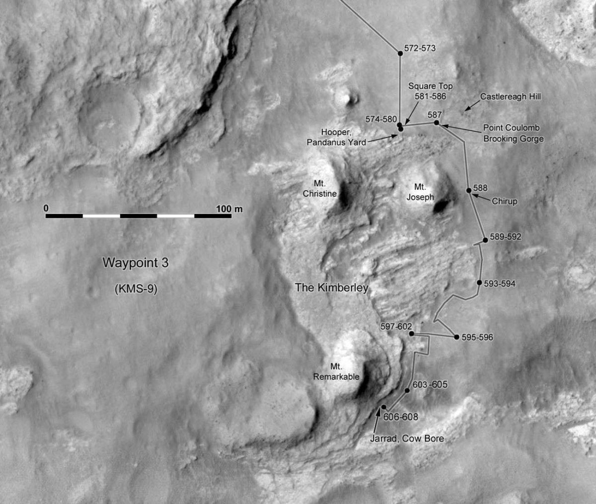
And here is how Curiosity drove to get there:

And now for a more detailed look at the last couple of weeks, with a lot of help from Ken Herkenhoff. My previous update covered plans through sol 596, but it turns out that they lost sol 596 to an anomaly. Ken said: "Unfortunately, the set of commands sent to the rover for Sol 596 were not received, so the rover correctly responded by executing the runout sequence that is appended to every day's command bundle. After confirming that the rover is healthy, the tactical team sent an only slightly modified version of the Sol 596 plan to the rover for execution on Sol 597." Sol 597 executed fine, but then they lost a whole weekend plan of sols 598 through 600 to another, apparently similar anomaly. Ken said of the lost weekend plan only that "there was another problem sending commands to the rover last weekend, and therefore the planned contact science and drive did not occur." It doesn't sound like either one was very serious, because they've kept right on going, with no further lost sols since then.
As a reminder, here's where we were on sol 595:

Because of the anomalies, the activities that Ken described in his update about sols 598 to 600 actually mostly took place on sols 601 to 603:
Sol 598 - 600 [activities actually took place 601-603] Update from Ken Herkenhoff: Preconditioning (12 April 2014)
...I was MAHLI/MARDI uplink lead, and focused on MAHLI imaging of the ChemCam window to determine how much dust is on it. We've taken such an image before when the window was in shadow, and wanted to try again with the window illuminated. We also planned MAHLI images of hardware on the remote sensing mast, to see if there are any signs of cable/fiber wear. Lots of ChemCam and Mastcam targeted observations are planned for Sol 598 [all this actually executed on sol 601], followed by APXS and MAHLI observations on the outcrop in front of the rover [executed on sol 602].
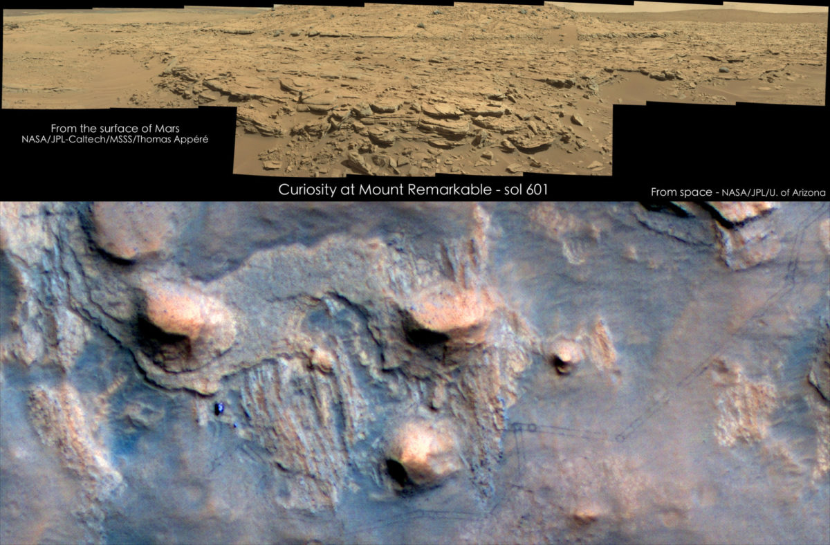
Here's a cool panoramic view of Mount Remarkable taken on sol 601, paired with a new HiRISE image of Curiosity from orbit. The archival version of that cool orbital image hasn't been released yet -- I'll wait to add it to our image library until I can play with the science data.

After their close approach to the middle unit on sols 597 through 602, they backed up from the outcrop, getting their wheels back on sand. Then they drove south and picked their drill site.
Sol 602 Update from Ken Herkenhoff: Mount Remarkable (15 April 2014)
I'm attending a 3-day meeting of the full MSL science team, so I'm less focused on rover operations than usual this week. After lots of interesting discussion of scientific data and hypotheses today, we did spend some time discussing where to drill and acquire a rock sample. The choices have been narrowed down to two locations on the flank of the hill called Mount Remarkable (at upper left, here). The scientific advantages of the two sites were discussed, and there were no major differences identified. But getting to one of the sites would involve driving over rough, rocky terrain that might damage the wheels, so that site was not favored.
Sol 603 Update from Ken Herkenhoff: Seeking a Drill Site (17 April 2014)
While most of the MSL science team met at Caltech to discuss recent results and plans for the near future, the tactical team planned a 65-meter drive toward the southeastern side of Mount Remarkable, near the site chosen for the next drilling campaign. The rover will pause in the middle of the drive to image the backup drill site, then acquire all the data needed to select contact science targets and bump to a drill site this weekend. Planning is restricted again, so untargeted science will be planned for Sol 604.
Sol 604 Update from Ken Herkenhoff: Test Results from the Mars Yard (18 April 2014)
Thursday was the last day of the MSL science team meeting, and the discussion shifted from science results to analysis of wheel wear, both on Mars and on Earth. The engineers at JPL have done a lot of testing in the Mars Yard and compared the results with the many images of the wheels on Mars. Although these images show that wheel wear continues, the damage is accumulating at a lower rate due to the changes in traverse planning that have been implemented in the past few months. Driving over rough terrain appears to be the most significant threat to the wheels, and efforts to recognize and avoid hazardous terrain using data returned by Mars orbiters have allowed safer drive paths to be chosen. It was clear that the engineers are not as concerned about wheel wear as they were last fall, and that they do not feel that wheel wear will limit the lifetime of rover mobility. This conclusion was based in part on tests in the JPL Mars Yard that showed that even very heavily damaged wheels performed well in climbing rocky and sandy slopes.
Sol 605 - 607 Update from Ken Herkenhoff: Windblown Soil (21 April 2014)
I was scheduled as MAHLI/MARDI uplink lead last Friday, so I stayed an extra day in Pasadena after the MSL team meeting and worked at JPL. It's always easier to work on tactical operations at JPL, and Friday was no exception as we planned contact science on the windblown soil in front of the rover. I spent some time with the rover planners laying out MAHLI images of the soil target that was also measured by APXS on Sol 605. Another drive toward potential drill targets was planned for Sol 606, followed by untargeted remote sensing on Sol 607.

Sol 608 - 609 Update from Ken Herkenhoff: Waiting on Post-Drive Data (22 April 2014)
Sol 608 Planning: The drive and other activities planned for last weekend went well, and lots of nice images of the outcrop in front of the rover were received early Monday morning. While the strategic rover planners analyzed the data and began evaluating various candidate drill targets, the tactical team planned lots of ChemCam and Mastcam observations of the candidates. Later in the day, the rover planners and scientists discussed the drill options, and selected a flat outcrop about 4 meters away, shown in the upper right part of this image. The goal for Sol 609 will be to bump the rover toward this outcrop, into a position that will allow drilling into it.
Sol 609 Planning: I'm MAHLI/MARDI uplink lead today, planning Sol 609. After ChemCam observations of targets Jarrad and Cow Bore, the rover will take another set of MAHLI images of the wheels, then bump a couple meters to get into position for contact science and drilling. Planning is restricted, so we won't receive the post-drive data until early Thursday. It was an easy planning day for me, as the end-of-drive MAHLI stowed image and MARDI twilight image have become routine.
Sol 610 Update from Ken Herkenhoff: Western Sky (23 April 2014)
The Sol 610 plan contains fairly simple, untargeted observations, including Mastcam and Navcam mosaics and a series of Navcam images of the western sky right after the sun sets behind Mt. Remarkable. Overnight, ChemCam will point at the dark sky and obtain calibration data, measuring thermal noise.
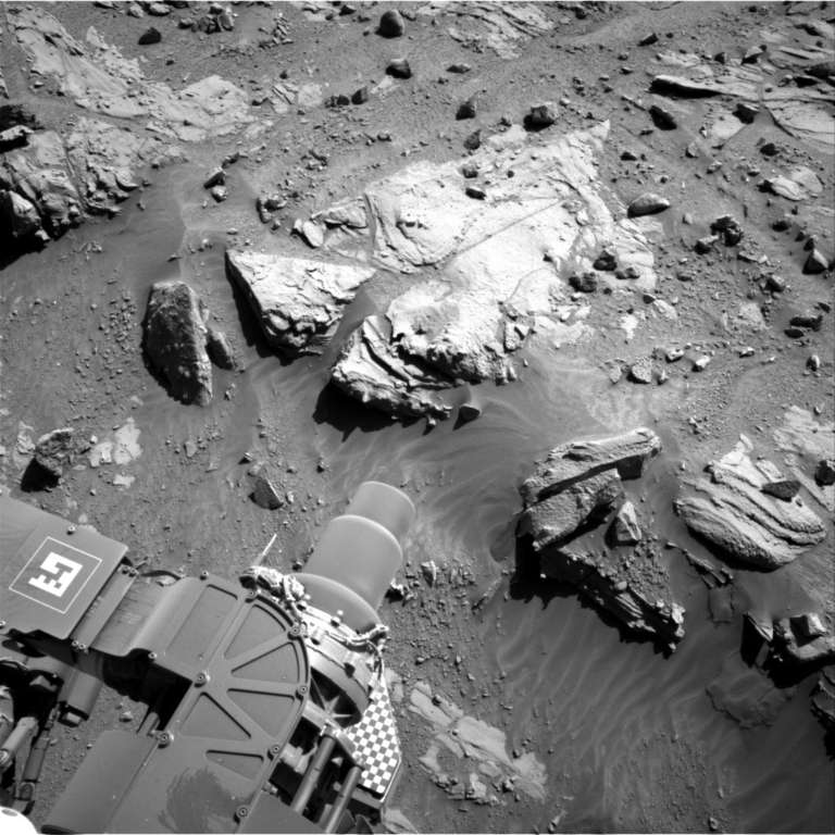
You can see a three-image zoom in on the drill site at the top of this post. Here is the most recent Navcam view, after the short drive on sol 609, with the selected site in easy reach of the arm.

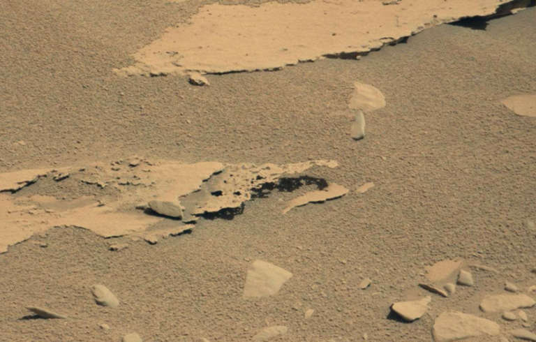
One final image: throughout their driving around the Kimberley, they've often spotted really fantastic shapes in the rocks. This one is, without a doubt, my favorite, originally spotted (as always) by a sharp-eyed user at unmannedspaceflight.com. I think it nicely illustrates how absolutely nothing but wind has eroded this landscape for eons. There's no other way you could get a sheet of rock as finely carved as this. It boggles my mind that a sedimentary rock on Mars can be so strongly cemented as to support a shape like this -- even with Mars' lower gravity. I'm looking forward to the results of the drilling campaign to find out more about what's gluing the sand grains in these rocks together.

Support our core enterprises
Your support powers our mission to explore worlds, find life, and defend Earth. You make all the difference when you make a gift. Give today!
Donate

 Explore Worlds
 Find Life
 Defend Earth

