Emily Lakdawalla • Sep 29, 2005
Another day, another natural disaster on Earth seen from space...
...but this one is much closer to home than Katrina and Rita were.
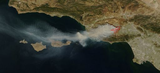
Below is an image captured today by the MODIS instrument on the Terra satellite.

View of the Topanga fire, southern California, from the MODIS satellite
detailed view of the Topanga fire burning in southern California at 11:35 local time on September 29, 2005. The red boxes indicate the location of a "thermal anomaly" detected in mid-infrared wavelengths -- in other words, they outline areas of active fires. Image courtesy of MODIS Rapid Response Project at NASA/GSFC
The view is of Los Angeles (lower right) and southern Ventura (center) counties here in southern California. The Planetary Society's headquarters is located not far from the right side of the map. My home is located quite close to one of those red boxes, which are outlines of pixels in the MODIS thermal infrared data that contain "thermal anomalies." Fortunately, my home is on the EAST side of those boxes, which -- as you can see from the direction that all the smoke is traveling out across Ventura -- is opposite to the direction that the wildfires appear to be traveling. I have been consulting websites from work all day trying to assess the progress of the fire. I know which nearby communities are being evacuated, but I couldn't find any maps that showed me where the fire was, so I couldn't figure out whether my neighborhood was really threatened or not. It didn't occur to me until tonight to check MODIS. Voilà! I have my answer -- the MODIS image shows me where the fires were at noon, and where the plume is traveling.
Thank you, MODIS, for giving me a little peace of mind. Now if they could only make a satellite that could clean up the air. Ashes are blowing around like a very light snowfall here, and it smells like the inside of a campfire.
Support our core enterprises
Your support powers our mission to explore worlds, find life, and defend Earth. You make all the difference when you make a gift. Give today!
Donate

 Explore Worlds
 Find Life
 Defend Earth

