Justin Cowart • Jul 08, 2016
Jupiter's Clouds: A Primer
NASA’s Juno spacecraft arrived at Jupiter on July 4, marking the agency’s return to orbit around Jupiter after a 13-year wait. Juno was primarily designed to study the interior of Jupiter, so imaging of Jovian weather has taken a back seat on this mission. The sole visible-light camera on Juno is JunoCam, which is a modified version of the camera used to take video of Curiosity’s descent into Gale Crater. For a good overview of the engineering behind JunoCam, I’d recommend checking out Emily’s write-up from 2011, and for an imaging schedule, check out her recent post.
Juno will be undertaking its tour of Jupiter in very elliptical polar orbits. At closest approach, Juno skims only 4,000-6,000 kilometers above Jupiter’s cloud tops. At its furthest, it’s more distant than Callisto. Each orbit will take two weeks. JunoCam is low-resolution as far as space cameras go, but the close orbit means that it can potentially take images capturing details in Jupiter’s atmosphere as small as 15 kilometers wide. This kind of resolution hasn’t been achieved since the Voyager flybys in 1979, and even then, only for a few hours around closest approach. The wider field of view also means that JunoCam will be capable of seeing much larger swaths of the cloud tops at a time than the Voyagers did. These high-resolution images will be taken during Juno’s orbits that are optimized for science, beginning in November.
In addition, JunoCam will also be providing some of the best views of Jupiter’s polar regions yet taken. Pioneer 11, which performed a polar slingshot around Jupiter in 1974, is the only spacecraft to get a direct, downwards-pointing view of Jupiter’s poles. Those images were hampered by the imaging system, a low-resolution polarizing polarimeter. The images produced with this instrument took nearly 30 minutes to acquire, and even near closest approach were limited to a resolution of around 100 kilometers per pixel.
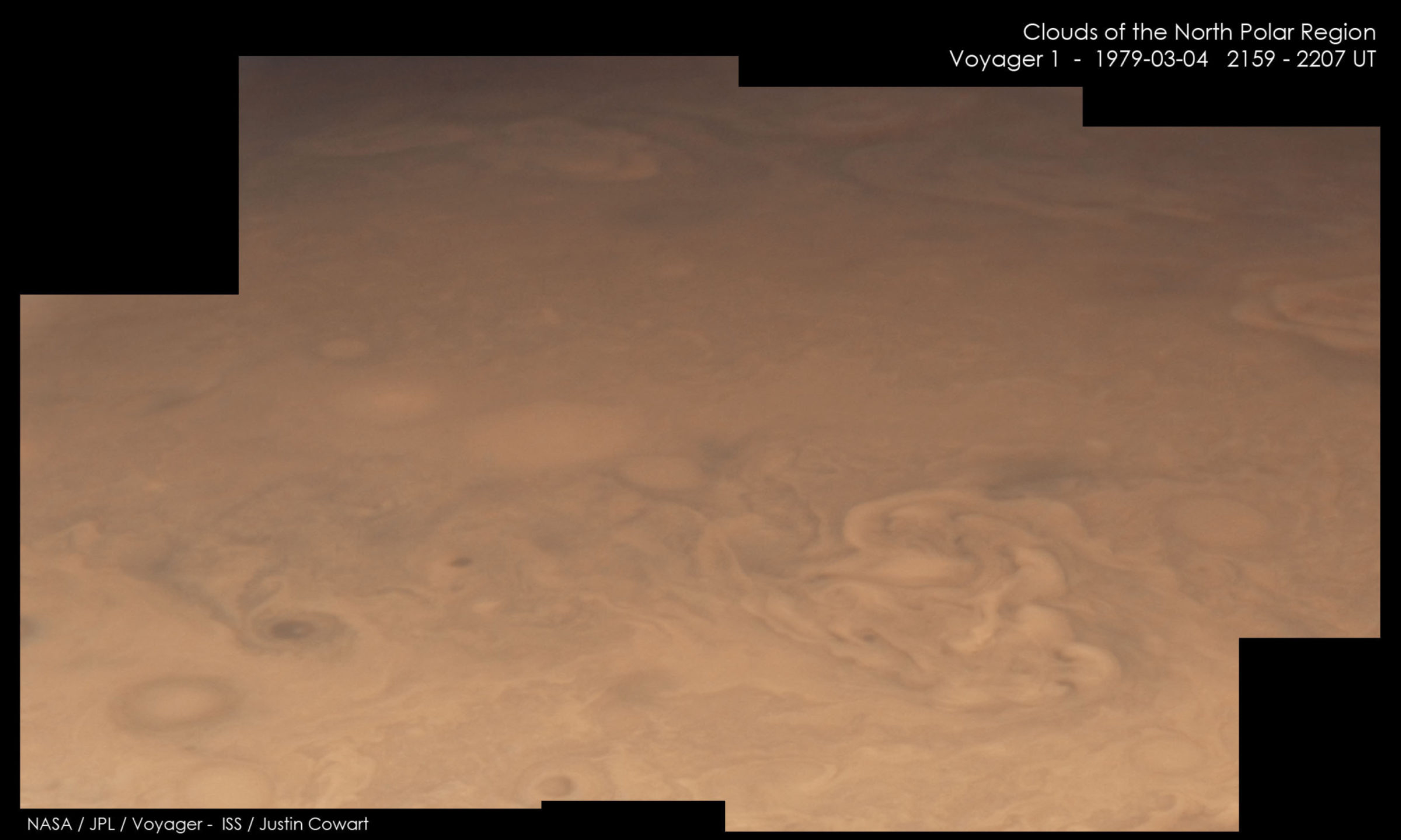
Neither the Voyagers nor Galileo were able to obtain clear views of the poles while they visited the Jupiter system. These spacecraft stayed near Jupiter’s equator, meaning that their views of the polar regions were extremely foreshortened. The shallow viewing angle also meant looking through a very thick slice of the atmosphere, so most cloud features had low contrast from stratospheric haze.
JunoCam was designed to be an instrument that is operated by the public, which will vote on which parts of Jupiter it should image. Because Jupiter’s cloud features can change weekly, or even daily, keeping an up-to-date map for planning purposes using professional telescopes is nearly impossible. There’s just not enough time available at observatories to image Jupiter frequently enough to track the changes, especially for a mission lasting more than a year. Instead, the JunoCam team is enlisting amateur astrophotographers as virtual co-investigators to take pictures of Jupiter as frequently as possible. This should allow JunoCam to target new areas of interest – say, an asteroid impact site or flare-up of a storm – much more rapidly.
Members of the public will help process the image output, too. Once the science mission starts, JunoCam’s pictures will be released almost immediately after they’re downlinked to Earth. From there, amateur image processors can take the data and play around with them. Who knows what will turn up? After all, this is new-ish territory to be covered. There is still much to learn about the relationships between Jupiter’s cloud layers, and how they interact with the planet’s interior structure.
Let’s hit the ground running once JunoCam gets to Jupiter. Here’s a quick primer on Jupiter’s clouds, and a preview of what to expect:

The most obvious features of Jupiter are its bands of light and dark clouds. These are bordered by jet streams blowing east and west. The light areas are called zones. The air inside zones is circulating anti-cyclonically, making them a broad area of higher air pressure. The increased pressure supports the formation of high-altitude clouds of white ammonia ice, which mostly obscure the deeper, more colorful clouds. The dark areas are called belts, and inside these the air circulates cyclonically. In the belts, the ammonia ice clouds aren’t thick enough to obscure the view, allowing us to see a deeper cloud deck of ammonium sulfide and ammonium hydrosulfide, as well as a rich brew of organic compounds. These chemicals could be giving the belts their brownish color.
The broad pattern of striped zones and belts remains constant over time, so they have been given names. The zones, heading from equator to pole, are the Equatorial Zone, North and South Tropical Zones, North and South Temperate Zones, and North North and South South Temperate Zones. The belts are similarly named: the North and South Equatorial Belts, North and South Temperate Belts, and North North and South South Temperate Belts. At higher latitudes are the Polar Regions. Although these have the same alternating east and west moving jet streams that form the zone/belt pattern, the air circulation isn’t as intense, which gives the polar regions a blander appearance in lower resolution views.
Now that we’ve covered the basic meteorology of Jupiter, let’s move on to more specific features.
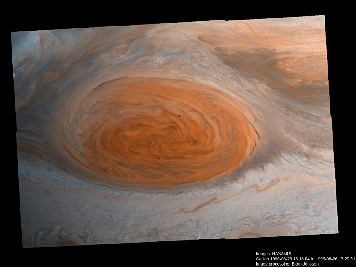
The Great Red Spot is probably Jupiter’s most famous and long-lasting feature. It resides on the southern edge of the South Equatorial Belt. Sightings may date back as far as 1664 (by Robert Hooke, who described a red spot, although his notes seem to put it in the North Equatorial Belt) or 1665 (by Giovanni Cassini, who placed the feature in the correct belt). There’s a big gap observations of the Great Red Spot after Cassini’s death in 1712, so it’s possible that this spot is not quite the same as the modern one. Observers picked it up again in 1830, and it has been sighted every year since 1879.
The GRS is a large anti-cyclonic feature, meaning it’s a high-pressure system. We associate these types of weather systems on Earth with tranquil weather, and this holds true for the central parts of the system. But around the edges, the winds whip around the Great Red Spot at speeds of 120 meters per second (430 kilometers per hour). The jet stream that forms the south edge of the South Equatorial Belt is forced to divert northward around the spot. The South Equatorial Belt downwind of the Great Red Spot, where the jet stream dives back to its normal latitude, is usually a region of extremely turbulent air flow. However, in some years (as in 2008 when New Horizons flew past) that turbulent region settles down. The diverging jet stream in this area often allows large convective systems to erupt through the turbulence. Perhaps Juno will spot some city-sized thunderstorm turrets poking through the high-level clouds.
The red color of the Great Red Spot is likely caused by the reaction of ammonia (NH3), acetylene (C2H2) and other hydrocarbons carried high over the system. Solar ultraviolet light is intense in the tenuous upper reaches of the atmosphere. Ultraviolet photons carry enough energy to knock the hydrogen atoms off these molecules. The escaping hydrogen frees up bonding sites for the two molecules to react with one another, forming more complex compounds that have a reddish color. The air currents over the Great Red Spot are sluggish, so these compounds become concentrated to make the clouds more reddish than outside the spot.
In recent years, the GRS has shrunk considerably. Today it is only about half the size that it was when the Voyagers visited. Models suggest that the Great Red Spot is sustained by small eddies in the jet stream transferring their rotational momentum to the spot’s circulation. High-resolution images by JunoCam may shed some light into this process, potentially giving us insight into the spot’s downsizing.


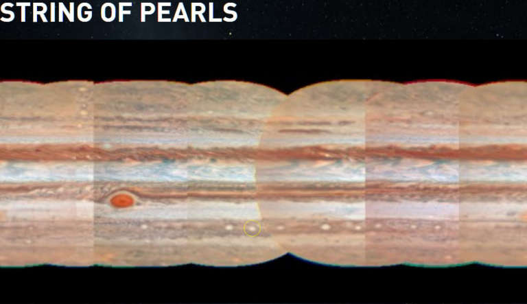
The South South Temperate Belt is home to a procession of small white ovals, leading to observers dubbing it a “string of pearls”. These white ovals are smaller relatives of the Great Red Spot. The jet streams are forced to divert around these small ovals, creating small turbulent patches in their wakes. Conditions in the South South Temperate Belt seem to be extremely favorable for spawning these ovals, more so than any other location on the planet. Monitoring the atmospheric circulation patterns in this region could help explain why.
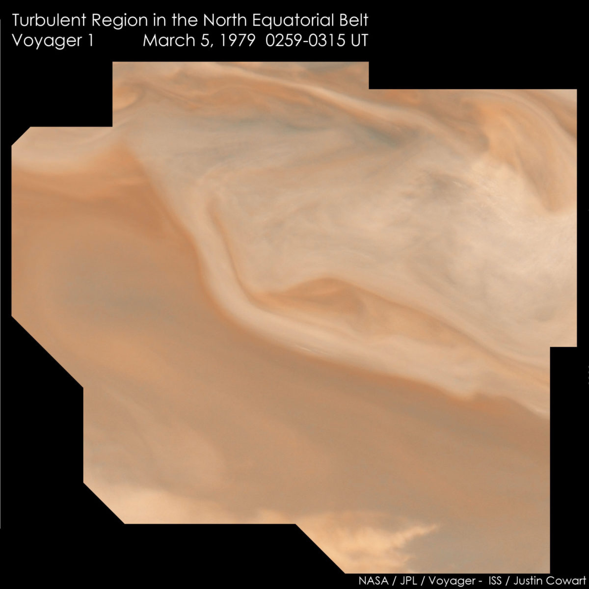
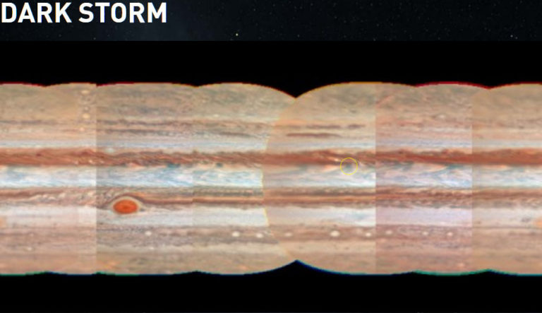
The southern edge of the North Equatorial Belt has a series of regularly spaced spots that are uniquely dark bluish-gray. These spots are bright in the infrared, meaning that they appear much warmer than their surroundings, consistent with a clearing in the clouds that allow us to see heat rising from deep cloud layers. By happenstance, the Galileo atmospheric probe dropped into one of these hotspots (which cover less than 1% of Jupiter’s surface area), revealing the air to be bone dry and cloud-free. This is probably due to forced sinking of higher-altitude, dry air in these regions.
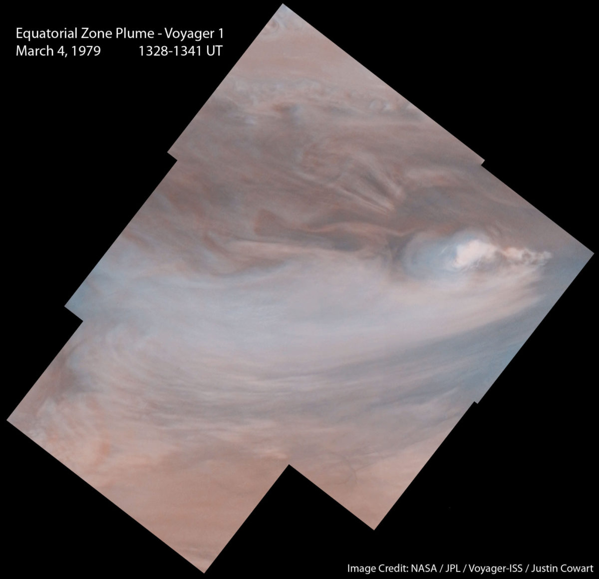
These dark spots are frequently paired with an area of intense thunderstorm activity, where large cloud turrets called plumes rise into the upper atmosphere and spread wispy ammonia clouds southwest into the Equatorial Zone. The intensity of the dark spots and the associated convective complexes are coupled: when the dark spot gets warmer, the convection intensifies and the plumes rise higher.
This behavior, combined with the regular spacing, suggests that there is an atmospheric wave pattern involved. Observations by the Cassini spacecraft as it flew by Jupiter en route to Saturn strengthened the case. The likely culprit is what is called a Rossby wave, which is a large meander in the jet stream. The dark spot is where the jet stream plunges 15-30 kilometers deeper in the atmosphere. As the air sinks into a region of higher pressure, compression warms it up. This raises the temperature above the dew point, evaporating the upper cloud decks to reveal a deep layer of water vapor clouds that aren’t normally visible. The convective complex forms where the jet stream rises again, carrying the vapor-rich air of the lower atmosphere upwards. That rising air decompresses and cools, which fuels thunderstorms as the vapor it carries condenses.
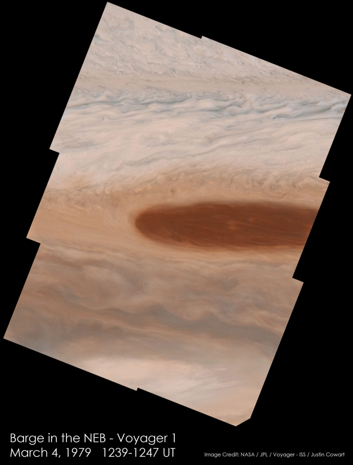
This spot is a small atmospheric feature known to astronomers as a “brown barge”. Barges are small cyclonic features located in belts. The sinking motion from these low pressure systems allow us to see down to a strongly colored cloud that could be ammonium sulfide or ammonium hydrosulfide in the deeper atmosphere, giving the belt a locally more intense color.
Barges are most frequently found in the North Equatorial Belt, although during 2014 and 2015, the North Temperate Belt hosted several large barges that have since dissipated. JunoCam may be able to catch one or more barges forming during its mission, giving atmospheric scientists insight into how these features develop and maintain their strength.
The low resolution of the Earth-based image makes it a bit difficult to make out what this feature is. It may be a high-latitude white oval, or perhaps a fresh new turbulent region. Turbulent regions flare up in the wake of small eddies in the jet stream, probably as the result of convective systems in the lower atmosphere. The turbulent regions can persist for weeks to months before the brighter material stirred up by the storm activity mixes into the atmosphere.
This Voyager-1 image shows some of the difficulty of getting clear views of the polar region from an equatorial spacecraft. Despite being taken near the spacecraft’s closest approach to Jupiter, the image detail is muted and the effective resolution is much lower. The southern edge of this photo is around 60 degrees north, while the top is very near the north pole. Images taken closer to the equator only span a few square degrees.
Throughout Juno's science mission, we will get some of the best images of Jupiter taken in nearly 30 years. JunoCam gives the public a chance to explore Jupiter in new ways, and the camera gives us a chance to add to an already spectacular archive of pictures. Once the mission ends in 2018, we will have to wait until the data from ESA's JUICE Ganymede mission or NASA's Europa mission are put into data archival to get as involved in exploring Jupiter.
Support our core enterprises
Your support powers our mission to explore worlds, find life, and defend Earth. You make all the difference when you make a gift. Give today!
Donate

 Explore Worlds
 Find Life
 Defend Earth


