Tanya Harrison • Apr 04, 2016
LPSC 2016: Martian Geomorphology
One of the very first sessions of the Lunar and Planetary Science Conference (LPSC) this year was titled, “Mars Geomorphology: Sedimentology/Stratigraphy, Impact-Related Features and Processes, and Gullies.” That’s a really long title that translates to: "anything happening on the surface of the Red Planet."
Ken Edgett kicked off the session, making his first appearance at LPSC in many years. Having worked at Malin Space Science Systems in the science group on the Mars Global Surveyor’s Mars Orbiter Camera (MGS MOC), Edgett has looked at every single MOC image—thus, he’s is famous in the community for knowing Mars like the back of his hand. Together, he and Mike Malin authored one of the key papers on Mars in the post-Viking era: Sedimentary Rocks of Early Mars. In the 15+ years since that keystone paper was published, our understanding of the sedimentary rock record on Mars has greatly expanded. A big part of this is thanks to the Mars Reconnaissance Orbiter (MRO) Context Camera (CTX), which has attained near-global coverage (~96%) of Mars at a stunning resolution of 6 m/pixel, and has covered about 50% of the planet more than once.

Edgett said that he couldn’t even try to make a map of sedimentary rock exposures on Mars because at this point, we’ve seen so many across the entire planet it would take years to do. Our view of Mars has shifted from a planet where no sedimentary rocks were known in the Viking era to a planet that now appears to be dominated by them. From orbital to rover scale, sedimentary rocks are ubiquitous across the planet. Edgett took the audience on a visual tour of a handful of examples.


Mars is surprisingly good at burying terrain. It’s also adept at exhuming buried terrain while leaving little trace that it was ever buried in the first place. Where all of that burying material goes once it’s been eroded is one of the martian conundrums. Edgett appropriately says in his LPSC abstract that studying the surface of Mars is “an exercise in asking the question, ‘What is missing?’ The question is deepened by also asking, ‘Is it missing because it is buried or because it was removed?’” Craters small and large have been buried and exhumed—Gale Crater being a prime example. Entire valleys networks have been filled, buried, and then exhumed in inverted form. It’s quite impressive.
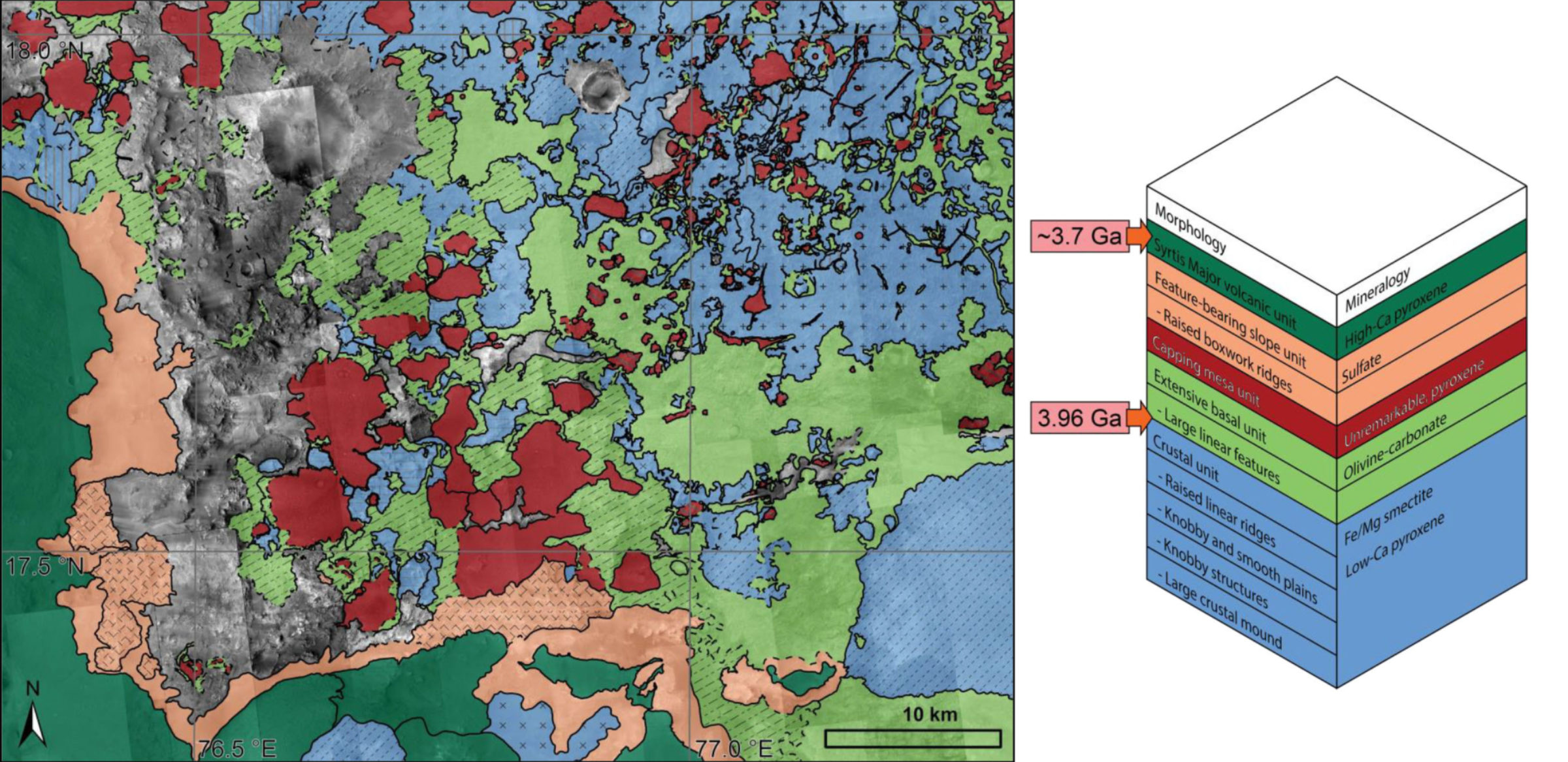
Mike Bramble, a graduate student at Brown University was up next, discussing the stratigraphy Northeast Syrtis Major. The particular location Bramble chose to study sits at the intersection between Nili Fossae, the Syrtis Major volcanic complex, and the Isidis impact basin. Nili was one of the final 5 candidate landing sites for the Curiosity rover, and is now on the list for the Mars 2020 rover. The mineralogy of the area suggests multiple past water-rich environments in between the time Isidis formed and when Syrtis volcanism began. Bramble and his colleagues thus set out to figure out the geologic history of the area. By combining CRISM spectral data with CTX and HiRISE image data, they were able to paint a picture of the stratigraphic sequence in the region:

As Bramble explains it: Northeast Syrtis Major bears outcrops of the largest olivine-rich rock unit on Mars. The high abundance of the mineral olivine in this rock suggests it came from primitive sources, such as eruptions very early in the history of Mars or as an impact melt sheet produced when the large Isidis impact basin formed. This olivine-rich unit bears spectral signatures of carbonate minerals, and these minerals on Earth are where a lot of the carbon dioxide in our atmosphere can be sequestered. Understanding the context and formation of these carbonate minerals is important for constraining the early atmosphere of Mars, and any potentially early habitable environments. High-spatial-resolution mapping confirms that the carbonate minerals identified in the region are only observed within the olivine-rich unit. Therefore, carbonate formation hypotheses that do not match this observation, such as the precipitation of carbonate from shallow ephemeral lakes, can be ruled out. The complex geological history of the region (for example, the emplacement of the olivine-rich unit as impact melt or volcanism shortly after the impact basin formed) and billions of years of erosion, interspersed with periods of aqueous alteration, has resulted in great small-scale morphological heterogeneity. This complexity is reflected in the 19 distinct geomorphic terrains noted in the figure above, but these can be united into a stratigraphic column composed of only 5 geologic units that span the Noachian-Hesperian boundary.
Jonathan Sneed, a research technician with the Solar System and Exoplanet Habitability Group at the University of Chicago, spoke next on the origin of sedimentary “mountains” within Valles Marineris. Sneed and his colleagues looked at the tilts of layers within these mounds using digital terrain models from HiRISE. They found that the layers generally dip away from the mound centres. Based on this, he suggested that the mountains formed as sedimentary mounds, as opposed to being deposited horizontally and then subsequently deformed.

Edwin Kite, also of the University of Chicago, gave a presentation on behalf of Leila Gabasova, a summer student of his. Gabasova’s project covered the effects of sediment compaction on layer orientation in Gale Crater. As in Sneed’s work, Gabasova found that layers in Gale tilt outward from the centre of Mount Sharp. Kite said that their layer tilts could only be explained if the surface beneath them is shaped like a central ring (see the following section on Fred Calef’s talk for more on this), if the layers compacted like shale, or if the sediment load was “dozens of kilometres” thick and torus-shaped. In either case, tilting of these layers after their formation could lead to fluvial deposits that seemingly appear to flow “uphill” in the layer configuration we see today.
Gabasova also looked at Gunjur Crater to see if compaction-induced subsidence (essentially slumping) of the sedimentary mound within Gunjur could have formed the visible concentric faults around the crater’s central peak and rim. Her results did indeed find that the compaction gradients were the highest near the crater rim and central peak. This supports her hypothesis that compaction is responsible for their formation.

[Due to computer and internet issues, I missed a few talks in the middle here, so I apologize to those speakers!]
By the time my computer and internet connect were working again, Fred Calef, known as the “Keeper of the Maps” for Curiosity at the Jet Propulsion Laboratory (JPL), was up. He discussed the morphology of Gale Crater and how it compares to other craters on Mars with high central peaks. Impact craters on rocky planets generally come in two flavours: simple and complex. Simple craters are small and bowl-shaped. Their maximum diameter varies across different planets/moons due to factors such as gravity and the properties of the “target material” into which the asteroid impacts. On Mars, simple craters are generally less than 7 km in diameter. Anything larger is a “complex crater”, which can be subdivided into central peak, peak ring, and multi-ring basins with increasing size. For a good summary of the differences and how they form, see this website from the Planetary Science Institute.
Gale Crater is a bit anomalous as its central peak stands almost as high as the crater’s southern rim, and a couple of kilometres higher than the northern rim. Fred found only 26 “high central peak” craters like Gale across all of Mars—all larger than 50 km in diameter. There were no regional or global relationships as to where these impact craters were found, suggesting target material doesn’t play into their formation. The conclusion from this study was that a small percentage of impacts on Mars had enough energy to create tall craters with central peaks without collapsing into a peak ring morphology. An audience member asked if this meant central peaks and peak rings are mutually exclusive features. Calef said probably not, but it’s something that requires further study.

Calef pointed out that over 1000 m of sediments fill the southern portion of Gale Crater. He then posed the question of what’s beneath them. Most certainly there are impact melt breccias—rocks melted from the shock/heat of the impact event—but how deeply are they buried? And how deep was Gale before it was filled, buried, and now exhumed? These are all big open questions when it comes to Gale.
Nicholas Warner of the State University of New York at Genesco spoke next on regolith thickness estimates at within the proposed InSight landing ellipse(s) in Elysium Planitia. His estimates for the regolith thickness were 3 to 5 meters. This is within the depth range to which InSight’s heat probe can penetrate—good news, because InSight’s engineers don’t expect the probe to be able to penetrate bedrock. So, thicker regolith means a greater penetration depth for the probe. He observed that some craters in the area have “rocky” ejecta—littered with boulders—while others don’t. So, he looked to see if there was a size cut-off at which “rocky ejecta craters” did vs. didn’t form. After analyzing over 3000 craters, he found that only craters larger than 200 meters in diameter had rocky ejecta. This suggests that these craters are excavating an additional layer in the subsurface relative to smaller craters: One that erodes into boulders, and one that does not. This tells us about the material’s resistance to erosion. Warner found that craters less than 800 million years old within the landing ellipses still preserved boulders on their ejecta blankets. This leaves the question of what happened to smaller craters with rocky ejecta. The calculated degradation rates in this region are too low to have caused the complete destruction of small craters and boulders, so they haven’t simply eroded away. It could be matter of image resolution limitations and/or lighting conditions, or the smaller craters might not excavate to the depth of the boulder-producing unit in the subsurface.
The rest of the session focused on gullies and recurring slope lineae. Matthew Sylvest of the University of Arkansas showed experimental results for gully slope constraints on Mars based on carbon-dioxide-sublimation-induced granular flows. In a small chamber under martian conditions, carbon dioxide frost was sublimated and then condensed onto regolith slopes consisting of a Mars soil simulant and two different grain sizes of sand. Videos of these experiments showed that carbon dioxide frost sublimation off the slopes triggered mass wasting—that is, landslides (but on a VERY small scale in the lab compared to nature). Interestingly, the greatest levels of mass wasting activity occurred on areas of the slope devoid of frost. In some rare cases, “large” carbon dioxide ice blocks dislodged on the slope. Across the three regolith types, the Mars soil simulant experienced the most mass wasting compared to the fine and coarse-grained sand. Sublimation triggered mass wasting on slopes as low as ~13°. This is significant as that’s way below what’s called the “angle of repose” for dry material. The angle of repose is the maximum angle at which entirely dry material can sit before sliding downhill under the force of gravity.

It’s important to note that the features formed at the lab scale in their experiments did not have the incised channel morphologies of martian gullies. While carbon dioxide frost sublimation may be a trigger for mass wasting within gullies, or on martian slopes in general, it’s not necessarily the sole initiator of gully formation. There is also an issue with attempting to conduct landslide experiments at the lab scale: Landslides on hillslope scales in nature behave differently. In nature, certain factors like viscosity play a significantly smaller role in how landslides behave relative to the lab scale. Because of this, the USGS constructed a 90-m-long flume in Washington state to study landslide mechanics on a more realistic scale. If you, like me, are fascinated by landslides, you can watch videos on their website of lots of different artificial landslides they’ve created in their flume!
Jorge Nuñez of the Johns Hopkins University Applied Physics Lab shifted things to a spectroscopic perspective, discussing the composition of martian gullies based on data from over MRO Compact Reconnaissance Imaging Spectrometer (CRISM) images. He found that most gullies are spectrally indistinct, particularly in high albedo areas. This isn’t surprising, as high albedo generally means dusty when it comes to Mars. Spectrometers can only tell you about the composition of a material down to a depth approximately equal to the wavelength you’re looking in (i.e., visible vs. infrared). CRISM operates in the visible and near-infrared (between about 500 and 3000 nanometers ), so it only tells us what’s in the uppermost part of the surface. If there’s a lot of dust, it obscures the spectral signal of anything beneath it.
In low albedo—that is, less dusty—areas however, Nuñez found that gullies were exposing underlying mafic minerals and transporting them downslope. In a few places in Noachian-aged terrain, gullies transporting underlying phyllosilicates downslope were found. Nuñez didn’t find any spectroscopic evidence for alteration minerals or evaporites within gullies channels—minerals that would hint at the former presence of water. Ken Edgett pointed out during the Q&A that this lack of detection doesn’t rule out the possibility of water or brine (really salty water) in gully formation on Mars, and Nuñez agreed.
JPL’s Serina Diniega was up next, talking about tracking gully activity within the north polar erg—dune fields collectively known as the Olympia Undae—near Mars’ northern polar cap. The informal names of these north polar dune fields should excite science certain fiction fans: Kolhar, Tleilax, Chusuk, & Furya. :) Diniega noted that the features in the north polar erg lack channels and so they might not be “gullies” by definition. The terrestrial definition of gullies includes “an incised channel morphology”. The features in the ergs also look very different from crater/valley/etc. wall gullies, so we’re probably dealing with a different beast here.

In any event, long-term monitoring of these features by HiRISE revealed recurring activity on the slipfaces (the steeper, downwind side of the dunes). They found the activity to be “extensive”, with over 500 new “gullies” formed in a single Mars year in some dune fields. This is extremely active compared to mid-latitude gullies, where activity has only been observed in a few dozen places. The activity appears to be concentrated around winter in both these dunes as well as in dune gullies in the southern high latitudes. Unfortunately, this is also the time of year that shadowing and Mars’ north polar hood—a thick shroud of clouds—obscures the area from imaging. This basically makes it impossible to constrain the formation time of these features within that season. We can only see that they've formed once the hood has cleared and the north polar region is no longer in shadow.
Diniega and her colleagues sought to answer the question of whether the activity observed on the dune slipfaces is triggered by sublimation-induced activity like that discussed in earlier talks in the session, by wind, or a combination of both. To do this, she’s looking at both gully formation and degradation—that is, the restoration of the dune slip faces to their pristine state. This tells you about the aeolian sediment flux in the area. Results from this are forthcoming. Why some dunes are more active than others is also still under investigation.
Amanda Allen, Diniega's student at Santa Barbara City College, wrapped up the session by focusing specifically on the Tleilax dune field within Olympia Undae. Side note: This is my favourite dune field on Mars. It’s just so pretty:

Using HiRISE images in JMARS and HiView, Allen tracked changes on dune slipfaces within single Mars years. As in Diniega’s aforementioned study, the gullies were only found on dune slipfaces, and occurred at a range of angles. The activity observed occurred during sometime in winter when the region was in shadow. This hinders the ability to constrain the timing of the activity very precisely. In four locations however, activity was observed before the polar hood and shadowing problem reared its ugly head. These locations experienced activity in late summer (between Ls 153–165). Sediment flux calculated from observing this activity was estimated at 0.004 square meters per sol. This is roughly consistent with sediment flux calculated for Nili Patera by Nathan Bridges and colleagues, at 0.006 square meters per sol. Allen said that her observations support the hypothesis that seasonal frost-related processes have an effect on altering Mars’ north polar dune gullies. As in Diniega’s talk, an audience member pointed out that calling these features “gullies” may not be appropriate as only consist of alcoves and fans while lacking incised channels. This summer, there will be a workshop on martian gullies held in the UK—perhaps at this meeting, the community can have a discussion and come together on terminology definitions going forward.
Support our core enterprises
Your support powers our mission to explore worlds, find life, and defend Earth. You make all the difference when you make a gift. Give today!
Donate

 Explore Worlds
 Find Life
 Defend Earth

