Emily Lakdawalla • Nov 20, 2018
We're going to Jezero!
NASA Selects Jezero Crater Landing Site for Mars 2020 Rover
NASA announced yesterday the selection of Jezero crater for the landing site of the Mars 2020 mission. Mars 2020’s launch period opens 19 July 2020, and landing will happen on 18 February 2021 regardless of the launch date. (“It’s a Thursday!” landing team lead Allen Chen said during today’s press briefing.)
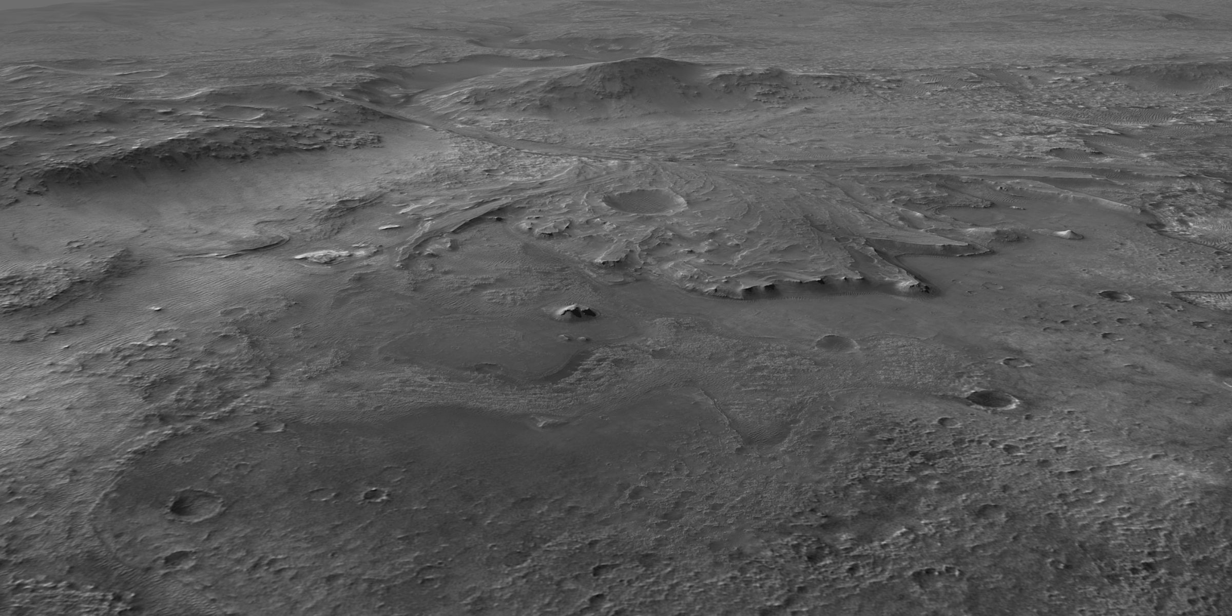
Jezero is a 45-kilometer-wide crater that once held a lake. It is named after a town in Bosnia and Herzegovina; thanks to Katherine Sredl for recording the correct pronunciation for me. Jezero contains a spectacular preserved river delta, which will be the focus of the rover’s primary mission. At Jezero, Mars 2020’s goal will be “to explore the history of water and chemistry in an ancient crater lake basin and associated river-delta environments to probe early Martian climates and search for life,” according to a mission overview for Jezero (PDF) by team members Sanjeev Gupta and Briony Horgan.
Finding Jezero
What and where is Jezero? To orient you, I made a few maps.
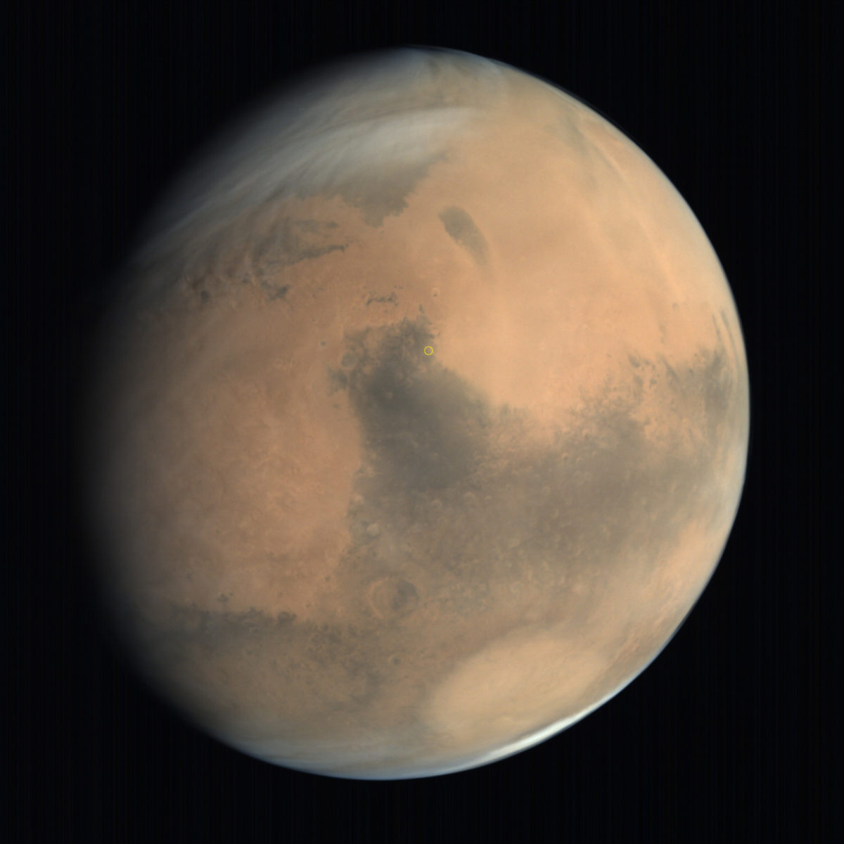
This is Mars, in a view from India’s Mars Orbiter Mission. Jezero crater is within the yellow circle just above center.
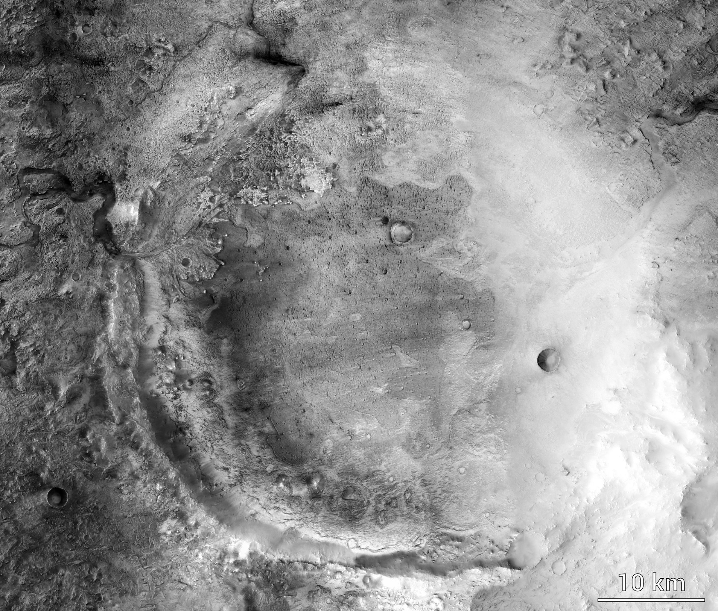
Here’s a nice crisp Mars Reconnaissance Orbiter Context Camera image of the whole crater. Look at the left side and you’ll see the delta.
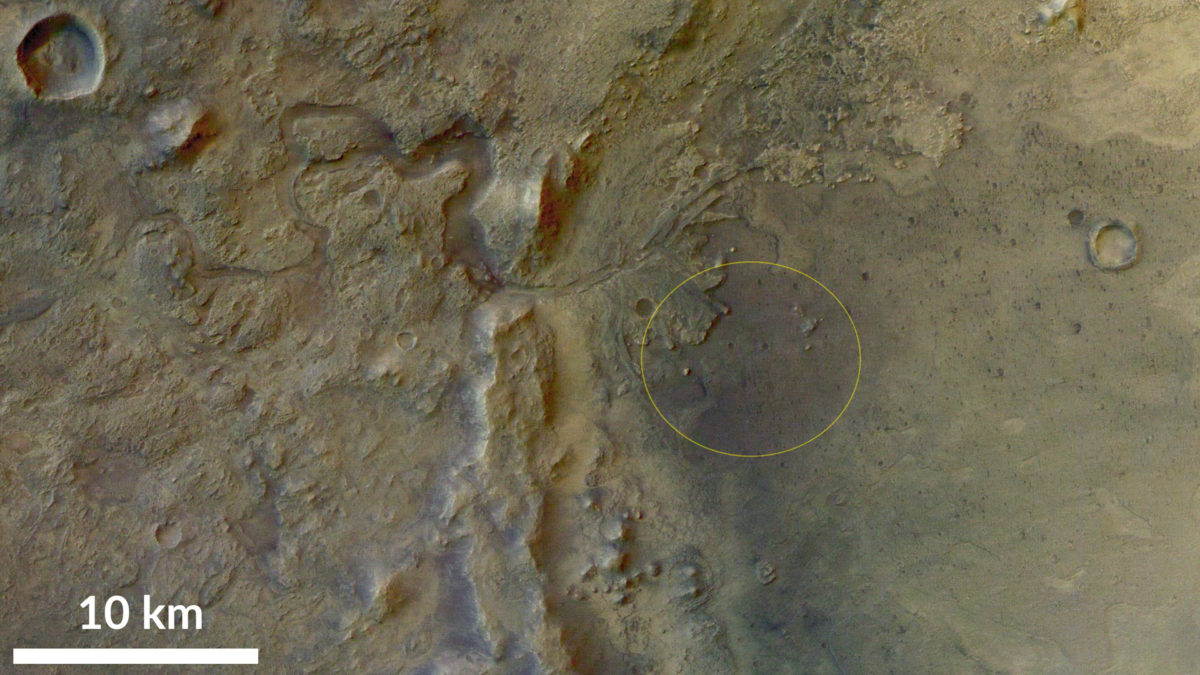
Zoom in some more, and here’s a pretty full-color view from Mars Express’ High Resolution Stereo Camera. It shows the western part of the crater, with the delta, as well as the dry channel that feeds into the delta. I copied the landing ellipse location from this presentation given to the final Mars 2020 landing site workshop (PDF).
And here is a magnificent flyover video that used Mars Reconnaissance Orbiter data:
Flight through Jezero crater A flight around the crater that will host the Mars 2020 mission based on data from Mars Reconnaissance Orbiter. The image and topography are from the Context Camera. The color is from the much wider-angle MARCI camera.Video: Robin L. Fergason / Andy Britton / Seán Doran
The Geologic Setting of Jezero Crater
Jezero crater is located at 18.4°N, 77.7°E in the Nili Fossae region of Mars. Jezero, like Gale crater (the Curiosity landing site), sits on the dichotomy boundary, where Mars’ more heavily cratered southern highland terrain gives way to the flatter terrain of the north. Specifically, Jezero is located at the northwest edge of the Isidis basin, which was the last of Mars’ large basins to form. The Isidis impact happened during Mars’ most ancient Noachian period, more than 3.9 billion years ago.
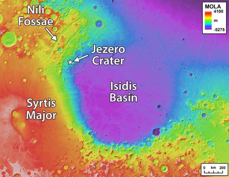
The stress of the impact caused the huge cracks and faults that form the Nili Fossae to the northwest of the crater. The Jezero crater-forming impact struck ejecta from the Isidis basin, so it happened after Isidis formed. Some time after Isidis formed, but still during Mars’ Noachian period, a distinctive rock unit featuring olivine as well as carbonate minerals was deposited in the Nili Fossae region to the northwest of Isidis. There’s a lot of other interesting geology in the region, which you can read about in this paper by Tim Goudge and coworkers (it’s open-access). They summarize: “The Nili Fossae region is also thought to be one of the locations on Mars with the largest diversity and most extensive exposures of alteration minerals...including exposures of Noachian crust that is altered to great depth.”
During this time, there was fluvial (river) activity. It’s not clear whether that was in the form of rain falling directly on the surface, or snowfall that later melted, or ice that precipitated directly out of the atmosphere and then melted at its base. Two river systems drained the Nili Fossae region and poured into Jezero crater, filling it with a lake as much as 250 meters deep. In fact, the original lake could’ve been deeper than that, but it was at least 250 meters deep because at some point, the lake breached Jezero’s rim to the northeast, and water flowed on out. This made Jezero an open lake system (with both inlet and outlet streams), for at least part of its history anyway, whereas Curiosity’s Gale crater was a closed lake system (once water entered, the only ways it could leave were by seeping into the ground or evaporating into the sky).

As the two inlet streams spilled into Lake Jezero, they dropped loads of sediment, forming deltas, including the spectacular southern one that will be Mars 2020's target. How long did the lake and the streams that fed it last? That’s one of the major unanswered questions about Jezero. The delta deposit could have formed in as short a time as 20 years. But the crater is filled with material; if all that material beyond the delta is actually sedimentary, it might have taken 1 to 10 million years to fill. That’s a pretty wide spread, and makes a huge difference to whether life might once have thrived there.
After the stream activity petered out some time in the middle Hesperian age of Mars’ history, the delta started eroding away. What we see today isn’t what the delta looked like after the last stream flowed across it; Mars’ winds were already attacking it. Then the Syrtis Major volcano got going to the southwest, and its eruptions continued into the most recent, Amazonian era of Mars’ history. Lavas from Syrtis spilled into Jezero, covering its floor and lapping up on to the bottom of the delta, but not covering the delta completely. Based on crater counting, that volcanic filling probably happened around 3.5 billion years ago, still during the Hesperian era. After the lavas, the delta — made of material that is less resistant to erosion than lava is — continued to erode away from wind action, probably right down to the present day.
Throughout some or all of this time, groundwater could’ve been percolating through the rocks, altering original minerals to new ones. At present, there is a wide variety of minerals exposed within Jezero and just outside it. There are many kinds of carbonates and clay minerals, which typically form in wet environments, in addition to the lava-related minerals that are more common on Mars. Some of those minerals formed from groundwater action; some of them formed when the delta deposits became rock; and some mineral grains might be unchanged from when they were first eroded from the rocks way outside of Jezero, a long time ago. Disentangling which minerals formed where, and what that tells us about the history of the geology and climate at the site, is work for geologists.
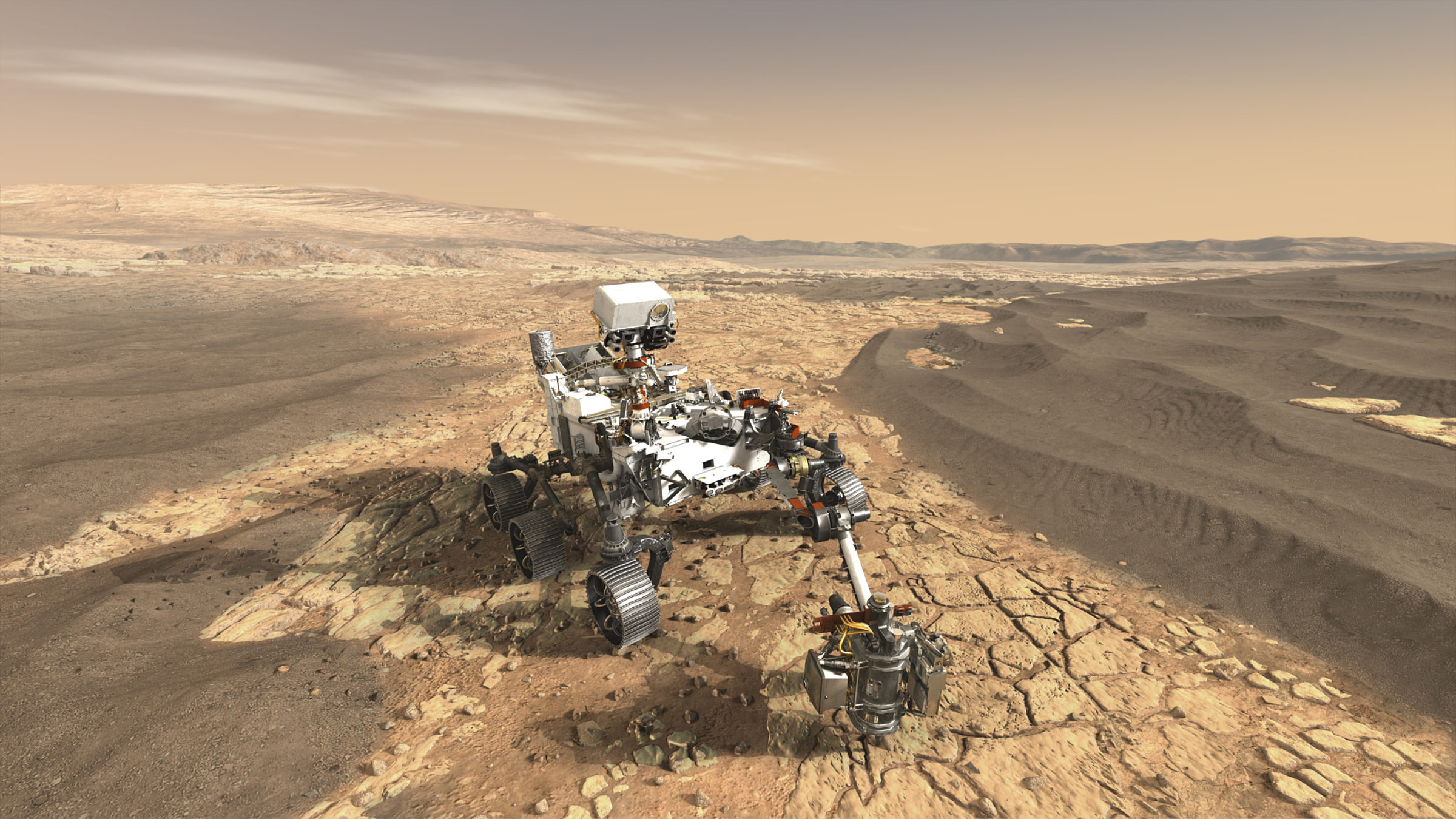
What Will Mars 2020 Do in Jezero?
As you can see, one of the pleasant things about the selection of Jezero at a landing site is that the geologic setting of a lake delta is one that geologists understand really, really well. We know exactly what kinds of sediments we expect to find at different elevations within the delta. We know exactly where to go to study rocks to try to answer most of our questions.
Sanjeev Gupta and Briony Horgan summarized the kinds of science questions that Mars 2020 will be able to address by landing in Jezero (PDF). You can check out their presentation to see them all, but here are a few highlight questions:
- How old is the lava unit that filled the crater floor? By studying it, can we better pin down the absolute ages corresponding to the eras already identified for Mars’ geologic history?
- What did the crust look like before the Isidis impactor slammed into it?
- When the Jezero impact happened, did the residual heat cause a hydrothermal system of percolating, mineral-rich water? If so, was life there?
- Did some of the carbonate minerals that we can see from space today form in a near-shore environment? If so, did that near-shore environment host life?
- What can we learn about the ancient, Noachian climate of Mars from the carbonates?
- Were the lakes and delta habitable environments, and if so, were they inhabited?
To answer these and other questions, Gupta and Horgan listed the following mission strategies and objectives. This is getting a bit technical, but I include it here for completeness.
- HABITABILITY - Determine if fine-grained lower delta strata, delta top, and carbonate-bearing units were habitable environments. Determine if serpentinization occurred in carbonate units.
- BIOSIGNATURE PRESERVATION – Search for organics derived from lacustrine environments in delta bottomsets, as well as morphological biosignatures in marginal carbonate units.
- RELATIVE CHRONOLOGY - Determine the relative age-relationships of the Mafic Floor, Carbonate-bearing Floor, and delta stratigraphy using stratigraphic observations
- IGNEOUS HISTORY - Determine igneous geochemistry of Mafic Floor unit (if volcanic flow or ash) or provenance/diagenesis if cemented sandstone
- CARBONATES - Characterize the texture, mineralogy and chemistry of carbonate-bearing Light-toned Floor and Marginal Carbonates, and regional olivine/carbonate unit
- LAKE EVOLUTION – Analyze delta succession and marginal deposits to determine open/closed basin history, number and duration of major lacustrine sequences, geochemical evolution of the lake
- NOACHIAN CLIMATE – weathering history of detrital and sub-aerial deltaic sediments, stratigraphic record of valley network activity, chemistry of surface waters, surface hydrology
- CHEMISTRY & HISTORY OF SUBSURFACE WATER – diagenesis of sedimentary rocks, chemistry of fracture-fills, alteration of olivine/carbonate-bearing units
Can Mars 2020 Really Do All That?
Those of you who followed Curiosity closely know that it took the rover a terribly long time to get moving toward the really interesting rocks. So Jezero’s selection is delightful for another reason: while most of the landing ellipse covers territory in the volcanic floor of the crater, not the delta, Mars 2020 will still be landing on the rocks it wants to study as part of the scientific mission. In other words, it’s not a “go-to” mission; it’s a “land-on” mission. Gupta and Horgan showed two notional traverses for what Mars 2020 might do, depending on where it lands inside the ellipse.
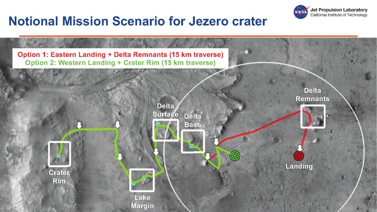
A key goal of the Mars 2020 mission is to look for rocks that could preserve biosignatures. “Biosignatures” is a catch-all term for many different types of records of ancient life, everything from isotopic hints of living chemistry to actual fossils. One of the best settings on Earth to look for ancient biosignatures is in very fine sediments that get deposited at the toe of a delta at its deepest point within the lake. So, after sampling the lava rocks that it lands on, Mars 2020 will beeline for rocks exposed somewhere at the delta toe, a drive that’s likely to be just a couple of kilometers and could be even shorter.
After sampling the delta thoroughly, looking at different parts of the system, Mars 2020 will go upslope, visiting the margin of the lake where the land met the water. If the mission is lucky, there will be many different lake margin deposits from different times in the lake’s history. That will take them right out of the landing ellipse. Then it’s on up to the crater rim to study rocks that once lay deeper below the surface. By this time, it’ll probably be beyond the rover’s primary mission.
After that, it’s within the realm of possibility that they could drive quite far, out of the crater entirely, to a different region that was considered as the “Midway” proposed landing site. There, they could explore the upland materials that once fed the streams, and then they will have studied an entire river system from sink to source.

Mission team members I’ve seen on Twitter seem quite excited about the choice of Jezero, though they would probably have been pretty happy with Northeast Syrtis or Midway, too. One team member remarked to me: “Within the team, and within the broader community, Jezero and Northeast Syrtis were essentially tied – they would both make great sites to visit, to collect samples for eventual return, and to learn new things about Mars and the solar system in general. In my opinion, the ‘tie breaker’ was the desire and the possibility to get to Midway in the extended mission. That is a risky strategy, of course, but I believe it is also gutsy and bold.”
Further reading:
Goudge et al. (2015) “Assessing the mineralogy of the watershed and fan deposits of the Jezero crater paleolake system, Mars.” Open access.
Gupta and Horgan (2018) “Mars 2020 Science Team Assessment of Jezero crater.” Presentation to the Mars 2020 4th Landing Site Workshop. Open access.
Mars 2020 Landing Site Working Group website with lots of digital resources
Jezero Crater feature at Gazetteer of Planetary Nomenclature
All HiRISE images taken of Jezero crater for the Mars 2020 Mission (which includes images of the ellipse as well as interesting regions outside the ellipse and even outside the crater)
Support our core enterprises
Your support powers our mission to explore worlds, find life, and defend Earth. You make all the difference when you make a gift. Give today!
Donate

 Explore Worlds
 Find Life
 Defend Earth

