Emily Lakdawalla • Jun 18, 2015
Transient hot spots on Venus: Best evidence yet for active volcanism
In a paper released in Geophysical Research Letters today, Eugene Shalygin and coauthors have announced the best evidence yet for current, active volcanism on Venus. The evidence comes from the Venus Monitoring Camera, which saw transient hot spots in four locations along a system of rifts near Venus' equator. They saw the hot spots in two distinct episodes in 2008 and 2009.
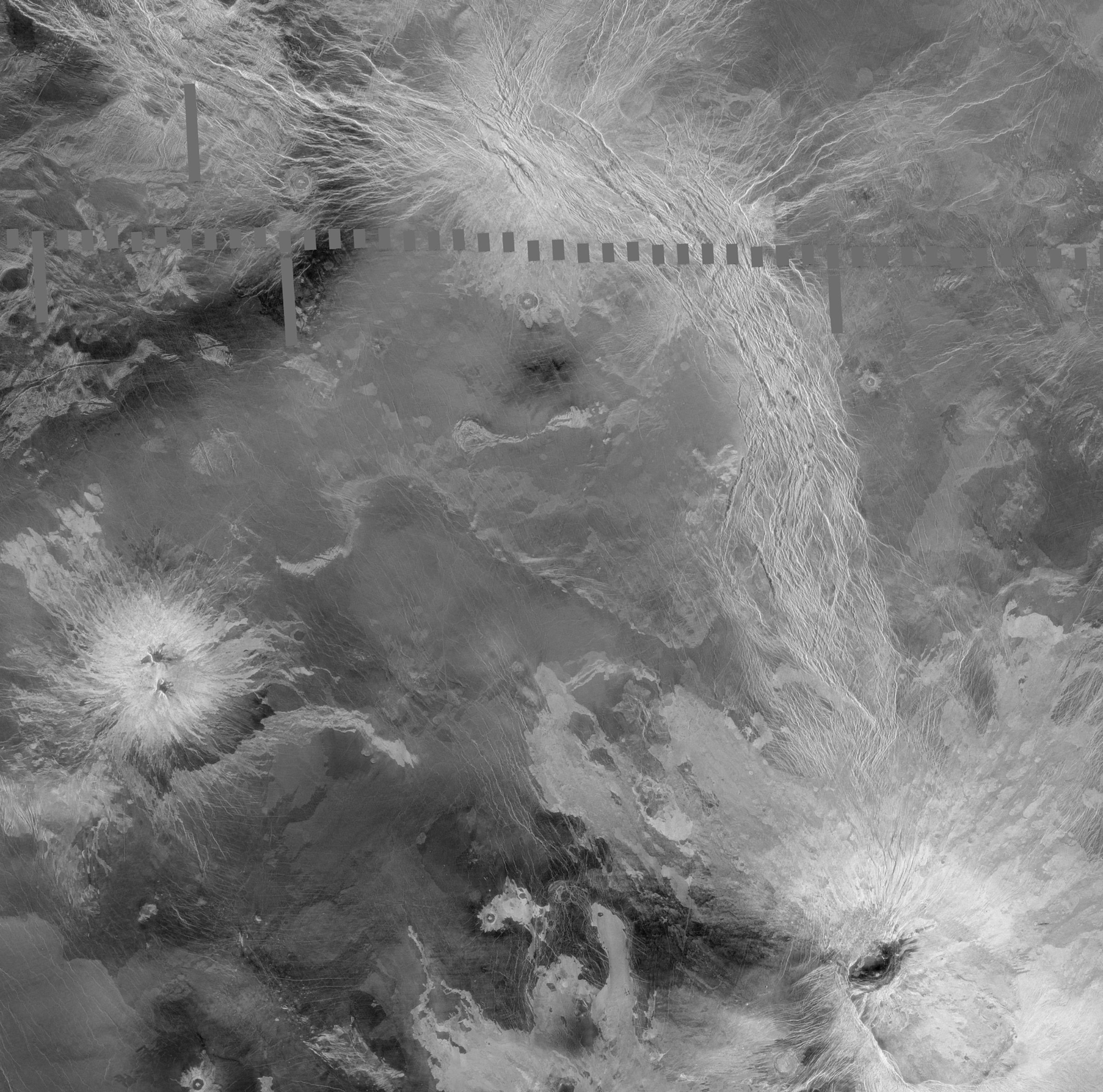
The press release describes the science pretty well, so I won't belabor that here; I thought I'd show you some pretty pictures of the region, made from Magellan data. Magellan obtained radar images of more than 97% of the planet, which have been merged into several enormous global data sets. To get the best-quality Magellan data you have to interact with an extremely klunky interface through the USGS, but it's well worth the effort. Here is the region in which Shalygin et al. report observing the hot spots. Click through twice to see it at its glorious full resolution. (Warning: 13 MB!)

Here, I've annotated the image with names of craters (yellow), mountains and chasmata (lighter and darker red), plains (blue), and the areas in which VMC saw hot spots (white).
These areas were imaged hundreds of times by VMC, but the hot spots only appeared very briefly. Crucially, two of the hot spots appeared in more than one orbit right after the other -- so it wasn't just one spurious detection. From the supplemental information to the paper, here's what we know about the hot spots:
- Spot "A" was observed on orbits 793 and 795 (June 21 and 24, 2008). If the spot was actually a very small area (less than 1 square kilometer), it might have been 900-1000K on orbit 793 and 900-1100K on orbit 795, then was not observed after.
- Spot "B" was observed one Earth year later, on orbits 1147 and 1148 (June 10 and 11, 2009). Depending on its size, it might have been 800 to 950K.
- Spot "D" was observed on orbit 1148 (the same as spot B) It might be a larger area 800 to 900K.
These are not quite "liquid hot magma" temperatures, but they're very close. If VMC was seeing the cooling surface of a lava flow, those temperatures would be very reasonable.
In making the map, I noticed that the paper seems to have a nomenclature error: they talk about "Ganiki Chasma," but they're actually talking about Ganis Chasma; its name has been confused for nearby Ganiki Planitia. (Ganis Chasma was named for a western Lapp forest maiden, while Ganiki Planitia was named for a Siberian water spirit.)
Do enlarge the top image by clicking through it twice to enjoy the beautiful diversity of the Venusian landscape. This area has it all: small shield volcanoes and gigantic volcanic constructs; wide spreading lava flows; impact craters, some of them filled by lava; a particularly fresh impact crater (Sitwell) with a dark parabola; and that system of fissures. Here is one zoom in on the region containing Shalygin's Objects A and D. I feel like I can almost make out landslides running down the chasm walls here. Magellan image resolution is always just short of what I really want to see the features I'm interested in.
If those hot spots are fresh lava flows, whence did they emanate? Did lava fill any of these chasms? If we were to return a radar mission to Venus, would this area have visible changes? There's only one way to find out. Let's go back to Venus!
Support our core enterprises
Your support powers our mission to explore worlds, find life, and defend Earth. You make all the difference when you make a gift. Give today!
Donate

 Explore Worlds
 Find Life
 Defend Earth


