Emily Lakdawalla • Nov 29, 2012
Water ice and organics at Mercury's poles
I originally wrote the post below on March 22 of this year, after the results were presented at the Lunar and Planetary Science Conference. There was a press briefing on the same findings today, on the occasion of them making it past peer review and being published in three papers in Science:
- Thermal Stability of Volatiles on Mercury
- Evidence for Volatiles on Mercury's Poles
- Neutron Spectrometer Reveals Water Ice on Mercury
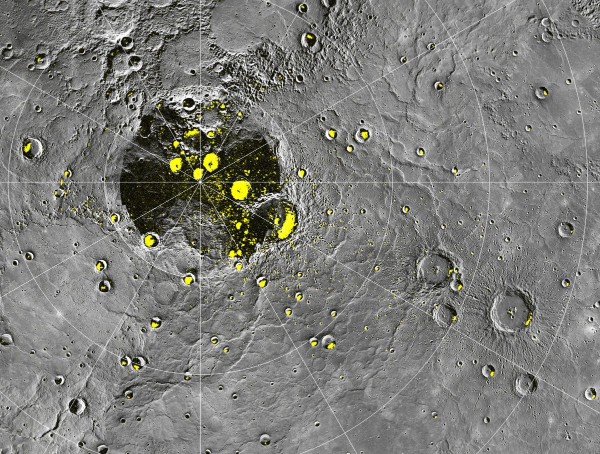
The story has not changed much from what I wrote below, except that the laser altimeter team now is reporting some spots within the permanently shadowed regions that do show upwards of 50% reflectance, consistent with water ice. I asked about that, and got a very nice detailed response from Carolyn Ernst:
The results Greg Neumann [representing the Mercury Laser Altimeter or MLA team] presented in March at LPSC used data that only ranged as far north as approximately 84 degrees. The two large MLA-bright deposits discussed at the press conference and in the Science paper are north of that latitude. We can only get MLA coverage north of 84°N by pointing the spacecraft off-nadir, and that was not done as often as nadir observations (and not done at all for the first six months of the mission). Once we started pointing off-nadir, we started getting coverage of the 'bald spot', but only slowly. It took a while to get enough tracks over those craters (Kandinsky and Prokofiev) to be sure we could measure a consistent bright signal. Basically, the MLA data presented at LPSC were in regions that got too warm to have large areas of stable surface water ice but could have water ice deposits buried by other material (and the MLA-dark measurements support thermal models hypothesizing organic material), but the colder areas closer to the pole can have larger expanses of stable surface water ice. The model data David Page presented here also did not include any MLA topography from within the 'bald spot', because that's what he had to work with at the time of his analysis. So he was unable to show the stability of water ice in the same craters that Greg showed. The longer MESSENGER can be kept running, the better our coverage in there will get.
Carolyn doesn't say it, so I will: Let's hope MESSENGER keeps getting mission extensions funded in order to keep building up the data to support this really cool story! To explain the whole story, I'm hereby reposting my old article, in case you missed it in March!
It's the morning of the fourth day of the 2012 Lunar and Planetary Science Conference, and I have to say that this one has been especially rich. It's very hard to choose what to write about. A nice little contained story is the one about water ice at Mercury's poles, a topic discussed in several talks yesterday.
Water ice at Mercury's poles? That's crazy, right? Mercury is so close to the Sun that it seems inconceivable that you could have water ice there. But Mercury's rotational axis has virtually no tilt (MESSENGER has measured its tilt to be less than 1 degree), so there are areas at Mercury's poles, most often (but not always) within polar craters, where the Sun never rises above the horizon to heat the surface.
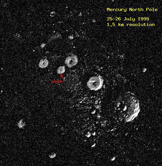
As Nancy Chabot told us in her talk, even before MESSENGER arrived we had some compelling evidence that there was ice at the poles. The Arecibo radio telescope had mapped the locations of unusually radar-bright material at Mercury's poles, material that modified radio waves in the way you would expect if it were water ice.

With MESSENGER's photos of the north pole, Nancy confirmed that allof the radar-bright areas seen by Arecibo are within a few pixels of regions that MESSENGER has never observed there to be any sunlight. Furthermore, nearly all craters larger than 10 kilometers diameter above 80 degrees north latitude contain radar-bright deposits. The 10-kilometer diameter is significant because that's the diameter at which Mercury craters transition from simple bowl shapes to more complex shapes. The geometry of simple craters is such that their sun-facing slopes absorb and then re-radiate solar heat into their shadowed crater walls, making it too warm for water ice to last. Anyway, looking at her images, it's really shocking how good the match is between Arecibo bright pixels and MESSENGER dark ones.

But there's a wrinkle. Greg Neumann presented some results from MESSENGER's Mercury Laser Altimeter that confused the issue a bit. (My own confusion also arises from the fact that they abbreviate Mercury Laser Altimeter "MLA," and every time any researcher said "MLA" my brain was determined to interpret that as my own name being mentioned.) The laser altimeter works by blinking a laser light at the surface and timing the return pulse; it's used to measure the topography, the highs and lows, of Mercury's surface. There's a happy by-product of the measurements of Mercury's topography, which is the brightness of the returned pulse of light. If there is ice in those shadowed regions, the flashlight of the laser altimeter should see a bright return pulse from the ice.
But the laser altimeter didn't see a bright pulse. In fact, wherever the laser altimeter hits these shadowed areas, it actually finds a surface that is darker than the sunlit rocks. And Mercury is pretty dark to begin with, much darker than the Moon; yet the stuff in those permanently shadowed regions is even darker, reflecting less than 10% of the light that hits it. This does not look like ice, not at all.
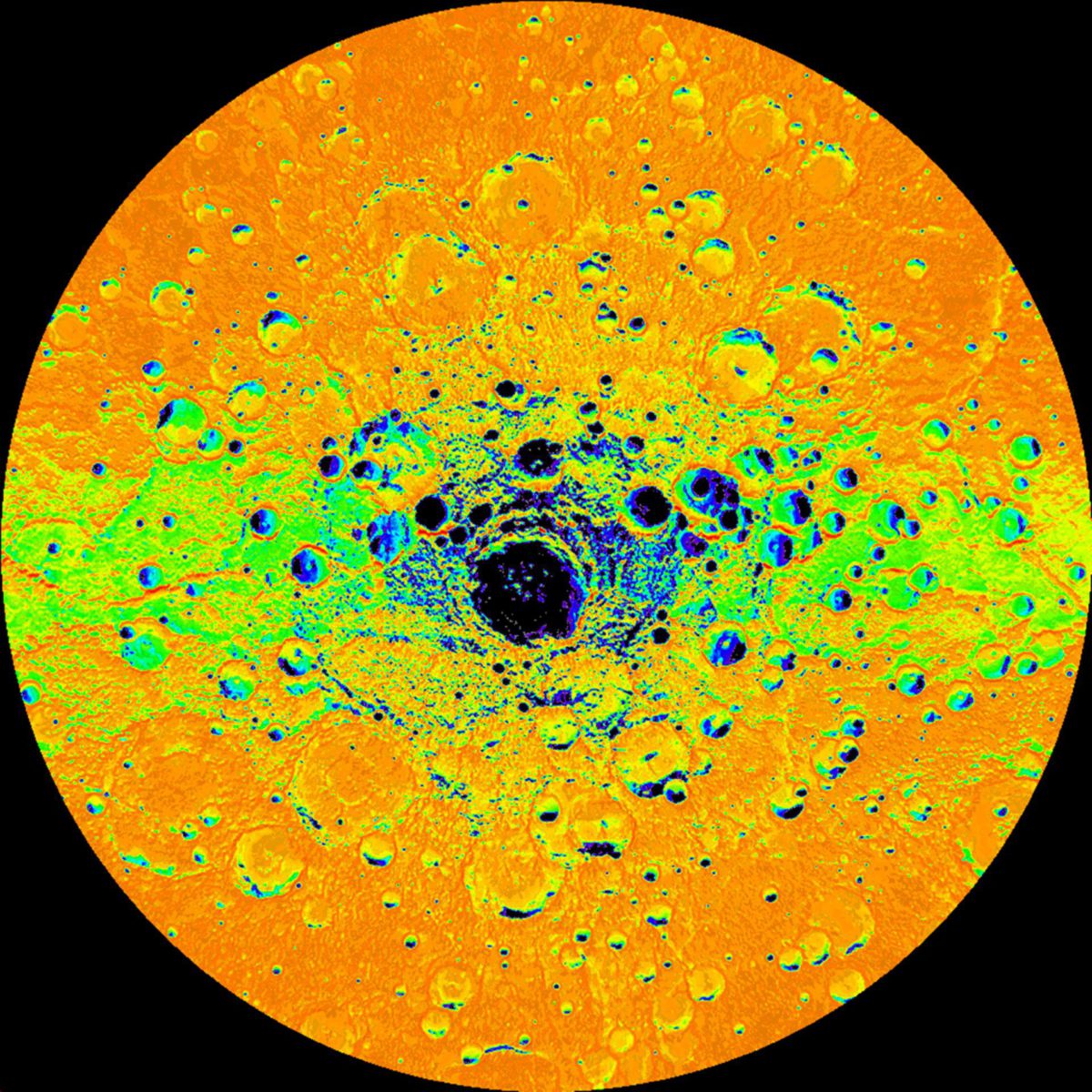
What could this stuff be? Well, temperature is a clue, and Dave Paige used the laser altimeter data to develop a model that showed what the average and extreme surface temperatures were at every spot near the poles. Here's a map that came out of one of those models. I'm not sure if this map shows annual extreme temperatures or annual average temperatures. You can see that there are dark spots within craters that are the coldest spots on this map. One other cool thing that I hadn't appreciated about Mercury is that its elliptical orbit combined with its 2:3 spin-orbit resonance results in some longitudes getting a lot more sun than other longitudes. Specifically, if you look at the map below, you'll see that there are colder temperatures at longitudes of 270 and 90 degrees (the left and right sides of this map) and hotter temperatures at longitudes of 0 and 180. Scientists refer to the 270 and 90 longitudes as the "cold poles."

The temperatures right at the surface in these dark spots are actually too hot for water ice to be stable at the surface. However, dig 10 or 20 centimeters down, and you get to a region where the temperature is around 100 Kelvin, and ice is stable. The conclusion from all of this: the permanently shadowed craters do contain water ice, but it's not right at the surface; it's sequestered about 10 or 20 centimeters below the surface. What's at the surface, then? It's some dark material that is stable at 170 Kelvin. There are several different things this could be, but Dave said they were favoring the hypothesis that the dark stuff is complex organic compounds like those found in carbonaceous chondrite meteorites. These compounds would be volatile elsewhere on Mercury -- that is, they're not stable as solids, but rather as gases -- but would get trapped in cold, permanently shadowed areas just the same way that water ice would, at rather higher temperatures. So: there's water ice at Mercury's poles, capped with a layer of carbon-rich material. Dave pointed out that this makes the permanently shadowed areas near Mercury's poles surprisingly habitable. Dig a very short distance below the surface and you have comfortable temperatures as well as access to water and organic material.
One final set of observations corroborates these conclusions. David Lawrence presented preliminary results of a year's worth of mapping of Mercury's poles with MESSENGER's Neutron Spectrometer. He began by pointing out how challenging it is to operate a Neutron Spectrometer in MESSENGER's highly elliptical orbit; the varying distance from the surface and varying speed with respect to the surface have to be accounted for. Simulations of what the Neutron Spectrometer should see if there were ice at the poles at the surface do not match the Neutron Spectrometer observations. Instead, their maps match what they'd expect if the water were buried about 10 centimeters below the surface.
These results will get even more robust with more measurements, as MESSENGER has been given a one-year mission extension. To begin the extended mission, they are going to burn through the rest of the oxidizer for their fuel in a maneuver to shrink their orbit from a 12-hour one to an 8-hour one. This will cut their apoapsis altitude from 15,000 to 10,000 kilometers. By getting closer to Mercury, they'll get better (or, if not better, different) measurements with the Neutron Spectrometer and other instruments that measure magnetic fields and energetic particles. Their gravity surveys will improve. They'll also be able to extend their laser altimeter mapping farther south. All good news!
Support our core enterprises
Your support powers our mission to explore worlds, find life, and defend Earth. You make all the difference when you make a gift. Give today!
Donate

 Explore Worlds
 Find Life
 Defend Earth

