Emily Lakdawalla • Aug 04, 2010
The enigmatic mounds of Acidalia Planitia
Acidalia Planitia is a large basin in Mars' northern lowlands, a dark splotch visible even from Earth telescopes. Many of the greatest canyon systems on Mars -- from Valles Marineris to Kasei, Ares, and Tiu Valles -- can be followed into Chryse Planitia, which must have collected vast amounts of floodwaters that carried on northwards until they reached bottom in Acidalia Planitia. Chryse and Acidalia together make the wide dark splotch covering the top right side of this global view of Mars from Hubble, immediately adjacent to the seasonal north polar cap:

Zoom toward Acidalia Planitia from space and the first thing you'll notice is the occasional sharp-rimmed impact craters with splatty outlines. It's not a heavily cratered place -- its floor is generally smooth and relatively crater-free compared to Mars' southern highlands, evidence that something must have wiped out its ancient crater record. That something could be the deposition of vast amounts of sediment carried within all those great outflow channels, but it's important to remember that volcanism, too, has played a big role in resurfacing Mars, and both processes likely operated here.
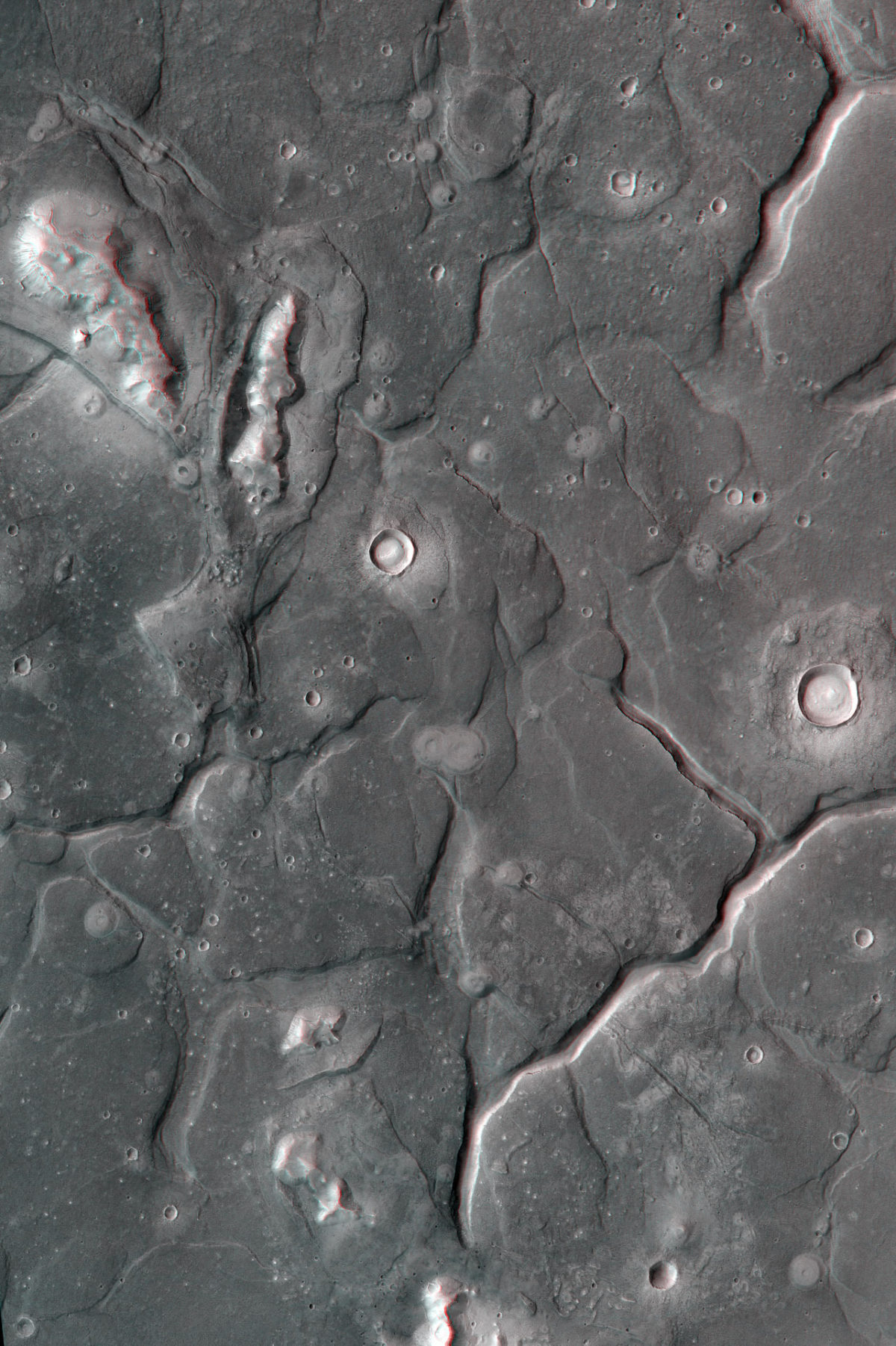
Zoom in a bit more and that generally smooth floor begins to look a bit lumpy; it starts breaking up into very large polygons, five or ten kilometers wide, separated by sharp canyons. Here and there, isolated plateaus rise up out of the landscape; one such plateau is the infamous "Face on Mars." Zoom in a bit more and you begin to notice odd little pimples on the polygons. Here is a glorious 3-D view of the region, courtesy of Mars Reconnaissance Orbiter's Context Camera or CTX.

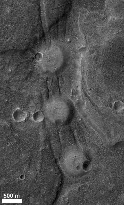
Those pimples are the Acidalia mounds. There are tens of thousands of them. They were first noticed in Viking images as being circular, low mounds with central pits, up to about a kilometer across, that looked brighter than the surrounding terrain. Their origin is mysterious; they've been interpreted as pseudocraters; cinder cones; tuff cones; pingoes; or ice-disintegration features. So they could have been caused from outside Mars, by impact cratering; from inside Mars, by active volcanism; or by surface processes on Mars, through the seasonal behavior of ground ice. So pretty much everything that could have been blamed, has been blamed! Here's a closer look at a few of them (this one is not 3-D).

More recently, they've been proposed to be mud volcanoes, and exploring that possibility is the subject of a paper recently published in Icarus by Dorothy Oehler and Carlton Allen titled "Evidence for pervasive mud volcanism in Acidalia Planitia, Mars." Mud volcanoes are found on Earth, like this one in Azerbaijan:
What are mud volcanoes? Oehler and Allen explain:
Mud volcanoes are terrestrial structures that extrude relatively low temperature slurries of gas, liquid, and rock to the surface from depths of meters to kilometers....These erupting slurries build circular to sub-circular deposits of mud and rock breccia ["breccia" means broken up rock chunks of many sizes, as opposed to the size-sorted, rounded cobbles you get in river and shore setings] that range in size from meter-scale lumps to mountains with diameters up to tens of kilometers and heights to 600 meters. They can produce domes, cones, caldera-like forms, or relatively flat structures, and the range of morphologies is thought to reflect physical properties (such as viscosity) of the rising slurries as well as proportions of gas, liquid, and sediment in the extruded materials.
..
Mud volcanoes occur in fluid-rich basins having thick accumulations of rapidly-deposited, fine-grained sediments. Upward mud flow is related to the buoyancy of the muddy and fluid-rich sediments, compared to the surrounding rocks....Upward movement of buoyant mud in the subsurface is commonly focused in zones of weakness along faults, fractures, and anticlinal structures [meaning domes or convex-upward folds in the rocks] near the surface. On Mars, mud volcanoes would indicate sites that have been rich in gas, liquid, fine-grained sediments, and possibly organic materials.
The paper goes on to make the case for these things being mud volcanoes. I mostly just skimmed the pictures, though, showing Earth mud volcanoes and many of these Martian mounds. It's quite something to imagine these things burping mud and rock and gas out of fissures in the ground.
The mud volcanoes are neat, but what are they telling us about Mars? First of all, Oehler and Allen suggest, it means that Acidalia is home to a very thick deposit of fine-grained sediment (which is what you'd expect given its location at the very end of the sediment transport highways of all those Martian valles), and very likely to a lot of subsurface water and/or ice. The thick pile of sediments might be pressurizing the groundwater, which could drive the mud volcanism. The very large number of mud volcanoes in this region suggests a triggering event that suddenly permitted widespread mud volcanism to happen. Maybe a frozen body of water sublimated; maybe volcanism from Tharsis triggered it; it's not really clear. Regardless of what caused them, their formation would have released a lot of gas, possibly including lots of methane. And the fact that they transport sediments from depth without lots of heat means they could be good places to study what Mars' underground rocks look like -- and whether they contain biosignatures; not to mention the fact that the groundwater circulation that is associated with the formation of these things might themselves be habitable environments.
I explored a couple of the incredibly high-resolution HiRISE images that cross these features, and you can too: try PSP_008522_2210; PSP_008483_2250; PSP_007770_2205; PSP_008548_2205; or PSP_003366_2185. But for me, this is one of those cases where I think I learned more from seeing them in a bit lower resolution with more of the regional context, which is where CTX excels. For this landscape in particular, where the interesting geology is both positive (mounds) and negative (troughs between polygons), it is incredibly helpful to have the CTX stereo image and a pair of red-blue glasses! Many thanks, as usual, to Tanya Harrison at MSSS for sending me the pretty 3D pic on request.
Support our core enterprises
Your support powers our mission to explore worlds, find life, and defend Earth. You make all the difference when you make a gift. Give today!
Donate

 Explore Worlds
 Find Life
 Defend Earth

